Enable Location

We need your location to show you interesting places around you

Discover nearby places

Find interesting locations and hidden gems around you

Precise directions

Get accurate directions and distances to places

Your location is never shared with other users. It's only used when you tap the location button.

Bardwell's Ferry Bridge

Log in to your account

Start exploring — it's free

Trusted by 61,909 travelers worldwide

Continue with Google
Continue with Apple
or

We will send you a code to connect

By continuing, you accept our Terms and Conditions and our Privacy Policy

Check your inbox

We've sent a pincode in your inbox. Please enter the code below.

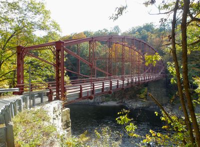
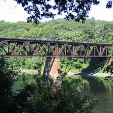
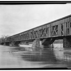
Bardwell's Ferry Bridge, Lenticular truss bridge in Conway, Massachusetts.

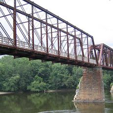
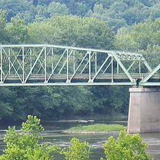
Bardwell's Ferry Bridge is a lenticular truss bridge spanning the Deerfield River between Shelburne and Conway using a steel framework. The crossing has a wooden plank deck and is supported by metal trusses with multiple paneled sections.

Completed in 1882 by the Berlin Iron Bridge Company, this structure replaced an earlier wooden crossing that had been destroyed by severe wind. The river crossing at this location had been used for transportation since the late 1700s.

This crossing point served as a vital link between communities for many generations. The bridge represents how people adapted engineering to maintain connections across the river.

The deck is relatively narrow and best suited for light vehicles and pedestrians. Access is straightforward, and the bridge offers a good vantage point over the river.

This bridge holds a local distinction as the longest single-span lenticular structure in the state. The construction uses built-up steel members joined together by riveting rather than welding.

The community of curious travelers

AroundUs brings together thousands of curated places, local tips, and hidden gems, enriched daily by 60,000 contributors worldwide.

Start exploring
Location
Inception
1882
GPS coordinates
42.55560,-72.67810
Latest update
December 14, 2025 11:01
Around this place
Bridge of Flowers
United States of America

Bridge of Flowers

7.4 km
Historic Deerfield
United States of America

Historic Deerfield

6.1 km
United States of America

Poet's Seat Tower

8.7 km
Shelburne Falls Trolley Museum
United States of America

Shelburne Falls Trolley Museum

7 km
Canalside Rail Trail Bridge
United States of America

Canalside Rail Trail Bridge

8.9 km
General Pierce Bridge
United States of America

General Pierce Bridge

8.5 km
Dedic Site
United States of America

Dedic Site

5.7 km
Pocumtuck Ridge Trail
United States of America

Pocumtuck Ridge Trail

7.9 km
Burkeville Covered Bridge
United States of America

Burkeville Covered Bridge

6 km
Main Street Historic District
United States of America

Main Street Historic District

7.2 km
The Wilder Homestead
United States of America

The Wilder Homestead

9.6 km
Leavitt-Hovey House
United States of America

Leavitt-Hovey House

7.4 km
Springfield Terminal railroad bridge, Deerfield
United States of America

Springfield Terminal railroad bridge, Deerfield

10 km
Garden Theater Block
United States of America

Garden Theater Block

7.3 km
Old Tavern Farm
United States of America

Old Tavern Farm

8.2 km
Robert Strong Woodward House and Studio
United States of America

Robert Strong Woodward House and Studio

10.3 km
Odd Fellows' Hall
United States of America

Odd Fellows' Hall

7.4 km
United States Post Office–Greenfield Main
United States of America

United States Post Office–Greenfield Main

7.5 km
Ashfield Plain Historic District
United States of America

Ashfield Plain Historic District

9.6 km
East Main-High Street Historic District
United States of America

East Main-High Street Historic District

7.6 km
Maj. Joseph Griswold House
United States of America

Maj. Joseph Griswold House

10.1 km
Conway Center Historic District
United States of America

Conway Center Historic District

5.5 km
Shelburne Free Public Library
United States of America

Shelburne Free Public Library

3.8 km
Massaemett Mountain
United States of America

Massaemett Mountain

7.8 km
Montague City Covered Bridge
United States of America

Montague City Covered Bridge

8.5 km
Chapel Brook Falls
United States of America

Chapel Brook Falls

10.5 km
Guiding Star Grange
United States of America

Guiding Star Grange

8.3 km
East Shelburne Cemetery
United States of America

East Shelburne Cemetery

6.2 km
Show the full map
« Bardwell's Ferry Bridge - Lenticular truss bridge in Conway, Massachusetts » is provided by Around Us (aroundus.com). Images and texts are derived from Wikimedia project under a Creative Commons license. You are allowed to copy, distribute, and modify copies of this page, under the conditions set by the license, as long as this note is clearly visible.

Discover hidden gems everywhere you go!

From secret cafés to breathtaking viewpoints, skip the crowded tourist spots and find places that match your style. Our app makes it easy with voice search, smart filtering, route optimization, and insider tips from travelers worldwide. Download now for the complete mobile experience.

Around Us App Screenshot

A unique approach to discovering new places

Le Figaro

All the places worth exploring

France Info

A tailor-made excursion in just a few clicks

20 Minutes

Around Us
Travel Guide & Maps
Download

Send to your phone

QR Code
1

Open the camera app on your mobile.

2

Point at the QR code with your camera. A notification will appear.

3

Tap the notification to open the link.