Enable Location

We need your location to show you interesting places around you

Discover nearby places

Find interesting locations and hidden gems around you

Precise directions

Get accurate directions and distances to places

Your location is never shared with other users. It's only used when you tap the location button.

Burkeville Covered Bridge

Log in to your account

Start exploring — it's free

Trusted by 61,914 travelers worldwide

Continue with Google
Continue with Apple
or

We will send you a code to connect

By continuing, you accept our Terms and Conditions and our Privacy Policy

Check your inbox

We've sent a pincode in your inbox. Please enter the code below.

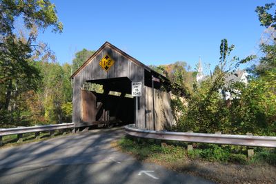
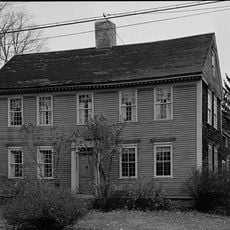
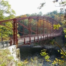
Burkeville Covered Bridge, Covered bridge in Conway, Massachusetts.

Burkeville Covered Bridge is a wooden structure crossing the South River, built with wooden trusses reinforced by iron vertical supports. The sides are covered with vertical wooden boards that protect the interior framework from weather.

An earlier bridge at this location was destroyed by flooding in 1869 and replaced by the current structure. This rebuilding represented a step forward in how engineers designed and built bridges during that period.

The bridge shows how 19th-century New England builders protected wooden structures from weather damage through complete covering. Walking across, you experience the same building style that was common throughout the region during that era.

This is a one-lane bridge on Main Poland Road where vehicles need to take turns crossing in each direction. Drive slowly and watch for oncoming traffic, as the passage is narrow and requires careful attention.

This bridge uses a modified Howe truss design with multiple iron tension rods instead of the standard wooden supports typical of similar structures. This technical choice makes it stand out to engineers and bridge enthusiasts who study regional construction methods.

The community of curious travelers

AroundUs brings together thousands of curated places, local tips, and hidden gems, enriched daily by 60,000 contributors worldwide.

Start exploring
Location
GPS coordinates
42.50778,-72.71111
Latest update
December 14, 2025 18:00
Around this place
Buttonball Tree
United States of America

Buttonball Tree

11.7 km
Bridge of Flowers
United States of America

Bridge of Flowers

11 km
Sugarloaf Mountain
United States of America

Sugarloaf Mountain

10.6 km
Historic Deerfield
United States of America

Historic Deerfield

9.8 km
Mount Sugarloaf State Reservation
United States of America

Mount Sugarloaf State Reservation

10.6 km
Bear Swamp
United States of America

Bear Swamp

10.4 km
D.A.R. State Forest
United States of America

D.A.R. State Forest

9.1 km
Shelburne Falls Trolley Museum
United States of America

Shelburne Falls Trolley Museum

10.5 km
Sunderland Bridge
United States of America

Sunderland Bridge

11.3 km
Bardwell's Ferry Bridge
United States of America

Bardwell's Ferry Bridge

6 km
Dedic Site
United States of America

Dedic Site

10 km
Pocumtuck Ridge Trail
United States of America

Pocumtuck Ridge Trail

10 km
Main Street Historic District
United States of America

Main Street Historic District

12.6 km
The Wilder Homestead
United States of America

The Wilder Homestead

11.6 km
Mountain Rest
United States of America

Mountain Rest

11.8 km
Garden Theater Block
United States of America

Garden Theater Block

12.7 km
Robert Strong Woodward House and Studio
United States of America

Robert Strong Woodward House and Studio

11.4 km
Odd Fellows' Hall
United States of America

Odd Fellows' Hall

11 km
Ashfield Plain Historic District
United States of America

Ashfield Plain Historic District

6.7 km
Maj. Joseph Griswold House
United States of America

Maj. Joseph Griswold House

11.3 km
Conway Center Historic District
United States of America

Conway Center Historic District

1.1 km
Whately Center Historic District
United States of America

Whately Center Historic District

9.9 km
Shelburne Free Public Library
United States of America

Shelburne Free Public Library

9.2 km
West Whately Historic District
United States of America

West Whately Historic District

8.1 km
Goshen Town Hall
United States of America

Goshen Town Hall

10.4 km
Massaemett Mountain
United States of America

Massaemett Mountain

12.4 km
Chapel Brook Falls
United States of America

Chapel Brook Falls

4.9 km
East Shelburne Cemetery
United States of America

East Shelburne Cemetery

11.9 km
Show the full map
« Burkeville Covered Bridge - Covered bridge in Conway, Massachusetts » is provided by Around Us (aroundus.com). Images and texts are derived from Wikimedia project under a Creative Commons license. You are allowed to copy, distribute, and modify copies of this page, under the conditions set by the license, as long as this note is clearly visible.

Discover hidden gems everywhere you go!

From secret cafés to breathtaking viewpoints, skip the crowded tourist spots and find places that match your style. Our app makes it easy with voice search, smart filtering, route optimization, and insider tips from travelers worldwide. Download now for the complete mobile experience.

Around Us App Screenshot

A unique approach to discovering new places

Le Figaro

All the places worth exploring

France Info

A tailor-made excursion in just a few clicks

20 Minutes

Around Us
Travel Guide & Maps
Download

Send to your phone

QR Code
1

Open the camera app on your mobile.

2

Point at the QR code with your camera. A notification will appear.

3

Tap the notification to open the link.