Enable Location

We need your location to show you interesting places around you

Discover nearby places

Find interesting locations and hidden gems around you

Precise directions

Get accurate directions and distances to places

Your location is never shared with other users. It's only used when you tap the location button.

Bear Swamp

Log in to your account

Start exploring — it's free

Trusted by 63,144 travelers worldwide

Continue with Google
Continue with Apple
or

We will send you a code to connect

By continuing, you accept our Terms and Conditions and our Privacy Policy

Check your inbox

We've sent a pincode in your inbox. Please enter the code below.

Bear Swamp
Discussion Reviews 1 Photos
3.3k Popularity

Bear Swamp, Protected natural area in Ashfield, Massachusetts, United States

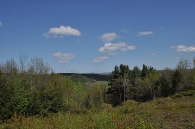
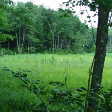
Bear Swamp is a protected natural area in Ashfield, Massachusetts, encompassing wetlands, forests, and waterways that create varied habitats. The site supports different animal species through its diverse landscape of water features and tree coverage.

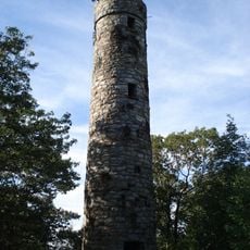
The land once functioned as pasture for sheep and a source of timber for local communities. Over time it transitioned into a protected wilderness area managed for conservation purposes.

The Trustees of Reservations manages this space, making it a destination where visitors engage with the natural environment and wildlife. Many come to observe how water, forest, and animal habitats work together in this landscape.

The site features marked trails suitable for walking through the different habitats, with parking available for visitors. Conditions and access rules change throughout the seasons, so plan accordingly.

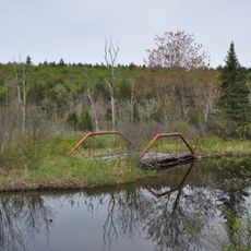
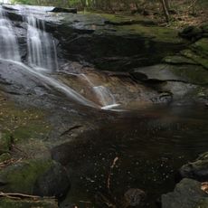
The Beaver Brook Trail passes a shallow pond where beavers built a dam directly atop an old stone milldam from another era. This layering reveals how nature has reclaimed and adapted human-made structures.

The community of curious travelers

AroundUs brings together thousands of curated places, local tips, and hidden gems, enriched daily by 60,000 contributors worldwide.

Start exploring
Location
GPS coordinates
42.54860,-72.82580
Latest update
December 12, 2025 09:02
Around this place
Mohawk Trail
United States of America

Mohawk Trail

14.7 km
Bridge of Flowers
United States of America

Bridge of Flowers

9.3 km
William Cullen Bryant Homestead
United States of America

William Cullen Bryant Homestead

12.8 km
Hail To The Sunrise Statue
United States of America

Hail To The Sunrise Statue

12.4 km
D.A.R. State Forest
United States of America

D.A.R. State Forest

10.4 km
Shelburne Falls Trolley Museum
United States of America

Shelburne Falls Trolley Museum

9.1 km
United States of America

Pocumtuck Mountain

12.3 km
Bardwell's Ferry Bridge
United States of America

Bardwell's Ferry Bridge

12.1 km
Heath Center Historic District
United States of America

Heath Center Historic District

13.9 km
Bissell Bridge
United States of America

Bissell Bridge

10 km
Burkeville Covered Bridge
United States of America

Burkeville Covered Bridge

10.4 km
The Wilder Homestead
United States of America

The Wilder Homestead

6.9 km
Mountain Rest
United States of America

Mountain Rest

9.9 km
Robert Strong Woodward House and Studio
United States of America

Robert Strong Woodward House and Studio

5.2 km
Coleman Bridge
United States of America

Coleman Bridge

13.9 km
Odd Fellows' Hall
United States of America

Odd Fellows' Hall

9.4 km
East Hawley Center Historic District
United States of America

East Hawley Center Historic District

4.6 km
Ashfield Plain Historic District
United States of America

Ashfield Plain Historic District

3.9 km
Charlemont Village Historic District
United States of America

Charlemont Village Historic District

9.7 km
Plainfield Center Historic District
United States of America

Plainfield Center Historic District

8.1 km
Maj. Joseph Griswold House
United States of America

Maj. Joseph Griswold House

5.4 km
Conway Center Historic District
United States of America

Conway Center Historic District

11.4 km
Shelburne Free Public Library
United States of America

Shelburne Free Public Library

12.1 km
East Charlemont District School
United States of America

East Charlemont District School

8.9 km
Goshen Town Hall
United States of America

Goshen Town Hall

12.1 km
Massaemett Mountain
United States of America

Massaemett Mountain

12 km
Chapel Brook Falls
United States of America

Chapel Brook Falls

9.1 km
East Shelburne Cemetery
United States of America

East Shelburne Cemetery

14.6 km
Show the full map
Reviews
Share your experience

No review yet

Discussions
Start a discussion...

No discussion yet

« Bear Swamp - Protected natural area in Ashfield, Massachusetts, United States » is provided by Around Us (aroundus.com). Images and texts are derived from Wikimedia project under a Creative Commons license. You are allowed to copy, distribute, and modify copies of this page, under the conditions set by the license, as long as this note is clearly visible.

Discover hidden gems everywhere you go!

From secret cafés to breathtaking viewpoints, skip the crowded tourist spots and find places that match your style. Our app makes it easy with voice search, smart filtering, route optimization, and insider tips from travelers worldwide. Download now for the complete mobile experience.

Around Us App Screenshot

A unique approach to discovering new places

Le Figaro

All the places worth exploring

France Info

A tailor-made excursion in just a few clicks

20 Minutes

Around Us
Travel Guide & Maps
Download

Send to your phone

QR Code
1

Open the camera app on your mobile.

2

Point at the QR code with your camera. A notification will appear.

3

Tap the notification to open the link.