Log in to your account

AroundUs is a community-driven map of interesting places, built by curious explorers like you. It grows with every review, story, and photo you share.
Connect to save your favorite spots, contribute locations, and create personalized routes.
Continue with Google
Continue with Apple
Continue with X
Continue with Facebook
Continue with email
By continuing, you accept our Terms and Conditions and our Privacy Policy
Create an account
Add to collection
Map
Suggest a change
Share

Pocumtuck Mountain, Mountain summit in Charlemont, Massachusetts, United States.

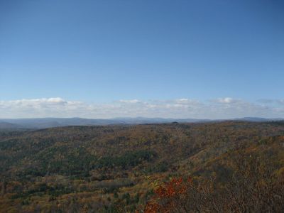
Pocumtuck Mountain is a summit in Charlemont reaching about 1,872 feet (570 meters), with views across western Franklin County and northern Berkshire County from its ledge. The exposed plateau at the top offers broad vistas, though access involves navigating around private land that surrounds these public forest areas.

The mountain received its name in 1855 during an Old Homes Days Festival, a community celebration that drew people together. That naming marked the formal recognition of the Pocumtuc people who had shaped the region's early history.

The mountain's name honors the Pocumtuc Native Americans who once lived in this region. Visitors walking across the summit plateau can connect with this historical presence that shaped the local landscape.

The summit lies within Catamount State Forest areas, but you must carefully navigate between public sections and private properties that border the peak. Give yourself extra time to find the right route and to confirm you are walking on accessible land.

Many visitors overlook how this peak's landscape prominence sets it apart from many other summits in the region. The broad views from the top extend across multiple counties in ways that make it geographically significant despite its modest height.

Location: Massachusetts

GPS coordinates: 42.65203,-72.77426

Latest update: December 13, 2025 17:04

Photos
Around this place
Mohawk Trail
United States of America

Mohawk Trail

14.7 km
Bridge of Flowers
United States of America

Bridge of Flowers

6 km
Hail To The Sunrise Statue
United States of America

Hail To The Sunrise Statue

11.5 km
Bear Swamp
United States of America

Bear Swamp

12.3 km
Shelburne Falls Trolley Museum
United States of America

Shelburne Falls Trolley Museum

6.5 km
Bardwell's Ferry Bridge
United States of America

Bardwell's Ferry Bridge

13.3 km
Heath Center Historic District
United States of America

Heath Center Historic District

4.6 km
Arthur A. Smith Covered Bridge
United States of America

Arthur A. Smith Covered Bridge

4.9 km
Bissell Bridge
United States of America

Bissell Bridge

8.1 km
Main Street Historic District
United States of America

Main Street Historic District

15.9 km
The Wilder Homestead
United States of America

The Wilder Homestead

5.8 km
Leavitt-Hovey House
United States of America

Leavitt-Hovey House

16 km
Garden Theater Block
United States of America

Garden Theater Block

16 km
Colrain Center Historic District
United States of America

Colrain Center Historic District

6.7 km
Old Tavern Farm
United States of America

Old Tavern Farm

11.8 km
Robert Strong Woodward House and Studio
United States of America

Robert Strong Woodward House and Studio

7.2 km
Odd Fellows' Hall
United States of America

Odd Fellows' Hall

6.1 km
United States Post Office–Greenfield Main
United States of America

United States Post Office–Greenfield Main

16.1 km
East Hawley Center Historic District
United States of America

East Hawley Center Historic District

13.1 km
Ashfield Plain Historic District
United States of America

Ashfield Plain Historic District

14 km
Charlemont Village Historic District
United States of America

Charlemont Village Historic District

8.6 km
East Main-High Street Historic District
United States of America

East Main-High Street Historic District

16.1 km
Maj. Joseph Griswold House
United States of America

Maj. Joseph Griswold House

7.1 km
Shelburne Free Public Library
United States of America

Shelburne Free Public Library

9.9 km
East Charlemont District School
United States of America

East Charlemont District School

3.4 km
Massaemett Mountain
United States of America

Massaemett Mountain

6 km
Guiding Star Grange
United States of America

Guiding Star Grange

15 km
East Shelburne Cemetery
United States of America

East Shelburne Cemetery

9.7 km
Show the full map
Reviews

Visited this place? Tap the stars to rate it and share your experience / photos with the community! Try now! You can cancel it anytime.

« Pocumtuck Mountain - Mountain summit in Charlemont, Massachusetts, United States » is provided by Around Us (aroundus.com). Images and texts are derived from Wikimedia project under a Creative Commons license. You are allowed to copy, distribute, and modify copies of this page, under the conditions set by the license, as long as this note is clearly visible.

Discover hidden gems everywhere you go!

From secret cafés to breathtaking viewpoints, skip the crowded tourist spots and find places that match your style. Our app makes it easy with voice search, smart filtering, route optimization, and insider tips from travelers worldwide. Download now for the complete mobile experience.

Around Us App Screenshot

A unique approach to discovering new places

Le Figaro

All the places worth exploring

France Info

A tailor-made excursion in just a few clicks

20 Minutes