Arthur A. Smith Covered Bridge

Log in to your account

AroundUs is a community-driven map of interesting places, built by curious explorers like you. It grows with every review, story, and photo you share.
Connect to save your favorite spots, contribute locations, and create personalized routes.
By continuing, you accept our Terms and Conditions and our Privacy Policy
Add to collection
Map
Suggest a change
Share

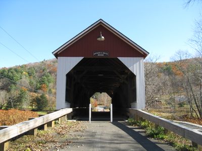
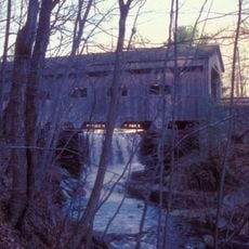
Arthur A. Smith Covered Bridge, Covered bridge in Colrain, United States.

The Arthur A. Smith Covered Bridge extends 100 feet across the North River with vertical pine board siding and a gabled slate roof.

Built in 1869, this single-span bridge received additional structural support through two large laminated lumber arches installed in 1920 to reinforce its construction.

The bridge represents traditional New England engineering methods, incorporating a Burr Truss design with ten braced king posts under tension from segmented timber arches.

Located at 1 Lyonsville Road, the bridge maintains a single traffic lane with an external width of 17 feet and internal clearance of 12 feet.

Following a $2.1 million restoration in 2007, the structure stands as Massachusetts' only remaining Burr truss bridge, positioned on elevated abutments above the floodplain.

Location: Colrain

GPS coordinates: 42.67000,-72.71917

Latest update: September 23, 2025 16:46

Around this place
Show the full map
Bridge of Flowers
United States of America

Bridge of Flowers

7.5 km
Poet's Seat Tower
United States of America

Poet's Seat Tower

13.7 km
Shelburne Falls Trolley Museum
United States of America

Shelburne Falls Trolley Museum

8 km
Pocumtuck Mountain
United States of America

Pocumtuck Mountain

4.9 km
Bardwell's Ferry Bridge
United States of America

Bardwell's Ferry Bridge

13.2 km
Turners Falls Road Bridge
United States of America

Turners Falls Road Bridge

14.6 km
Heath Center Historic District
United States of America

Heath Center Historic District

8.4 km
Bissell Bridge
United States of America

Bissell Bridge

13 km
Green River Covered Bridge
United States of America

Green River Covered Bridge

12.5 km
Main Street Historic District
United States of America

Main Street Historic District

13.4 km
The Wilder Homestead
United States of America

The Wilder Homestead

9.2 km
Leavitt-Hovey House
United States of America

Leavitt-Hovey House

13.4 km
Garden Theater Block
United States of America

Garden Theater Block

13.4 km
Colrain Center Historic District
United States of America

Colrain Center Historic District

1.8 km
Bernardston Congregational Unitarian Church
United States of America

Bernardston Congregational Unitarian Church

13.9 km
Old Tavern Farm
United States of America

Old Tavern Farm

8.7 km
Robert Strong Woodward House and Studio
United States of America

Robert Strong Woodward House and Studio

10.9 km
Odd Fellows' Hall
United States of America

Odd Fellows' Hall

7.5 km
United States Post Office–Greenfield Main
United States of America

United States Post Office–Greenfield Main

13.5 km
Charlemont Village Historic District
United States of America

Charlemont Village Historic District

13.5 km
Powers Institute Historic District
United States of America

Powers Institute Historic District

13.6 km
East Main-High Street Historic District
United States of America

East Main-High Street Historic District

13.5 km
Maj. Joseph Griswold House
United States of America

Maj. Joseph Griswold House

10.7 km
Shelburne Free Public Library
United States of America

Shelburne Free Public Library

9.4 km
East Charlemont District School
United States of America

East Charlemont District School

7.6 km
Massaemett Mountain
United States of America

Massaemett Mountain

5.6 km
Guiding Star Grange
United States of America

Guiding Star Grange

11.9 km
East Shelburne Cemetery
United States of America

East Shelburne Cemetery

7.8 km
Show the full map

Reviews

Visited this place? Tap the stars to rate it and share your experience / photos with the community! Try now! You can cancel it anytime.

« Arthur A. Smith Covered Bridge: Covered bridge in Colrain, United States » is provided by Around Us (aroundus.com). Images and texts are derived from Wikimedia project under a Creative Commons license. You are allowed to copy, distribute, and modify copies of this page, under the conditions set by the license, as long as this note is clearly visible.

Discover hidden gems everywhere you go!

From secret cafés to breathtaking viewpoints, skip the crowded tourist spots and find places that match your style. Our app makes it easy with voice search, smart filtering, route optimization, and insider tips from travelers worldwide. Download now for the complete mobile experience.

Around Us App Screenshot

A unique approach to discovering new places

Le Figaro

All the places worth exploring

France Info

A tailor-made excursion in just a few clicks

20 Minutes