Bissell Bridge

Log in to your account

AroundUs is a community-driven map of interesting places, built by curious explorers like you. It grows with every review, story, and photo you share.
Connect to save your favorite spots, contribute locations, and create personalized routes.
Continue with Google
Continue with Apple
Continue with X
Continue with Facebook
Continue with email
By continuing, you accept our Terms and Conditions and our Privacy Policy
Create an account
Add to collection
Map
Suggest a change
Share

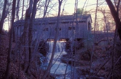
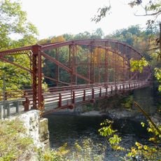
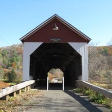
Bissell Bridge, Covered bridge in Charlemont, Massachusetts.

Bissell Bridge is a covered crossing over Mill Brook in Charlemont with stone-faced reinforced concrete supports. The wooden structure is protected by external walls and a roof, serving as an active traffic connection on Heath Road.

The bridge was built in 1951 by T.J. Harvey Company and replaced an earlier structure from 1881. It became the first covered bridge constructed in Massachusetts during the 20th century.

The bridge shows how New England communities blend old building styles with modern materials while keeping the traditional covered bridge form alive. It remains part of local identity and reflects the region's choice to maintain its infrastructure in a historical style.

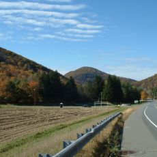
The crossing is easily reached via Heath Road, also known as Massachusetts Route 8A, and remains an active traffic route. The surroundings are open for viewing, so visitors can see the structure from above and from the sides.

The structure stands near an old mill dam and pond that once supported local industry. It took its name from Henry W. Bissell, a local resident whose earlier home was just a few hundred feet away.

Location: Massachusetts

GPS coordinates: 42.63250,-72.86944

Latest update: December 14, 2025 18:08

Photos
Around this place
Mohawk Trail
United States of America

Mohawk Trail

7 km
Bridge of Flowers
United States of America

Bridge of Flowers

11 km
William Cullen Bryant Homestead
United States of America

William Cullen Bryant Homestead

18.9 km
Hail To The Sunrise Statue
United States of America

Hail To The Sunrise Statue

3.7 km
Bear Swamp
United States of America

Bear Swamp

10 km
Shelburne Falls Trolley Museum
United States of America

Shelburne Falls Trolley Museum

11.3 km
United States of America

Pocumtuck Mountain

8.1 km
Bardwell's Ferry Bridge
United States of America

Bardwell's Ferry Bridge

17.9 km
United States of America

Borden Mountain

13.4 km
Heath Center Historic District
United States of America

Heath Center Historic District

6 km
Arthur A. Smith Covered Bridge
United States of America

Arthur A. Smith Covered Bridge

13 km
The Wilder Homestead
United States of America

The Wilder Homestead

8.3 km
Whitingham Village Historic District
United States of America

Whitingham Village Historic District

17.6 km
Colrain Center Historic District
United States of America

Colrain Center Historic District

14.8 km
Robert Strong Woodward House and Studio
United States of America

Robert Strong Woodward House and Studio

7.8 km
Coleman Bridge
United States of America

Coleman Bridge

15.1 km
Odd Fellows' Hall
United States of America

Odd Fellows' Hall

11.1 km
East Hawley Center Historic District
United States of America

East Hawley Center Historic District

7.7 km
Ashfield Plain Historic District
United States of America

Ashfield Plain Historic District

13.5 km
Charlemont Village Historic District
United States of America

Charlemont Village Historic District

653 m
Plainfield Center Historic District
United States of America

Plainfield Center Historic District

13.5 km
Maj. Joseph Griswold House
United States of America

Maj. Joseph Griswold House

7.9 km
Shelburne Free Public Library
United States of America

Shelburne Free Public Library

15.6 km
East Charlemont District School
United States of America

East Charlemont District School

6.8 km
Massaemett Mountain
United States of America

Massaemett Mountain

12.6 km
Chapel Brook Falls
United States of America

Chapel Brook Falls

19 km
East Shelburne Cemetery
United States of America

East Shelburne Cemetery

16.6 km
Savoy Mountain State Forest
United States of America

Savoy Mountain State Forest

13.4 km
Show the full map
Reviews

Visited this place? Tap the stars to rate it and share your experience / photos with the community! Try now! You can cancel it anytime.

« Bissell Bridge - Covered bridge in Charlemont, Massachusetts » is provided by Around Us (aroundus.com). Images and texts are derived from Wikimedia project under a Creative Commons license. You are allowed to copy, distribute, and modify copies of this page, under the conditions set by the license, as long as this note is clearly visible.

Discover hidden gems everywhere you go!

From secret cafés to breathtaking viewpoints, skip the crowded tourist spots and find places that match your style. Our app makes it easy with voice search, smart filtering, route optimization, and insider tips from travelers worldwide. Download now for the complete mobile experience.

Around Us App Screenshot

A unique approach to discovering new places

Le Figaro

All the places worth exploring

France Info

A tailor-made excursion in just a few clicks

20 Minutes