Enable Location

We need your location to show you interesting places around you

Discover nearby places

Find interesting locations and hidden gems around you

Precise directions

Get accurate directions and distances to places

Your location is never shared with other users. It's only used when you tap the location button.

Bridge of Flowers

Log in to your account

Start exploring — it's free

Trusted by 63,131 travelers worldwide

Continue with Google
Continue with Apple
or

We will send you a code to connect

By continuing, you accept our Terms and Conditions and our Privacy Policy

Check your inbox

We've sent a pincode in your inbox. Please enter the code below.

Bridge of Flowers
Discussion Reviews 1 Photos
8.3k Popularity

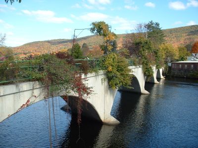
Bridge of Flowers, Pedestrian garden bridge in Shelburne Falls, Massachusetts.

The Bridge of Flowers is a former railway bridge that crosses the Deerfield River, joining Shelburne Falls and Buckland as a walkway for pedestrians. Its arches and supporting piers hold layers of soil that sustain hundreds of plant varieties.

The structure was built in 1908 as a railway bridge for freight trains and stopped operating in 1927. Local residents then transformed it into a garden in 1929.

The bridge gardens are tended by the Shelburne Falls Area Women's Club, which changes the plantings with the seasons. Visitors walking across notice how the community takes care of this shared place year after year.

The crossing is free and open year-round, though flowers and plants reach their peak from April through October. Parking is available nearby, and you can easily walk to local shops and dining options.

The structure holds substantial layers of soil engineered to support plant growth on its surfaces. This innovative approach allows hundreds of plant species to flourish on what was once purely industrial infrastructure.

The community of curious travelers

AroundUs brings together thousands of curated places, local tips, and hidden gems, enriched daily by 60,000 contributors worldwide.

Start exploring
Location
Official opening
1908
GPS coordinates
42.60410,-72.74050
Latest update
December 8, 2025 19:58
Around this place
Bear Swamp
United States of America

Bear Swamp

9.3 km
Shelburne Falls Trolley Museum
United States of America

Shelburne Falls Trolley Museum

519 m
United States of America

Pocumtuck Mountain

6 km
Bardwell's Ferry Bridge
United States of America

Bardwell's Ferry Bridge

7.4 km
Heath Center Historic District
United States of America

Heath Center Historic District

10.2 km
Arthur A. Smith Covered Bridge
United States of America

Arthur A. Smith Covered Bridge

7.5 km
Bissell Bridge
United States of America

Bissell Bridge

11 km
Burkeville Covered Bridge
United States of America

Burkeville Covered Bridge

11 km
Main Street Historic District
United States of America

Main Street Historic District

11.6 km
The Wilder Homestead
United States of America

The Wilder Homestead

3.2 km
Leavitt-Hovey House
United States of America

Leavitt-Hovey House

11.7 km
Garden Theater Block
United States of America

Garden Theater Block

11.6 km
Colrain Center Historic District
United States of America

Colrain Center Historic District

8.5 km
Robert Strong Woodward House and Studio
United States of America

Robert Strong Woodward House and Studio

4.7 km
Odd Fellows' Hall
United States of America

Odd Fellows' Hall

68 m
United States Post Office–Greenfield Main
United States of America

United States Post Office–Greenfield Main

11.8 km
Ashfield Plain Historic District
United States of America

Ashfield Plain Historic District

9.4 km
Charlemont Village Historic District
United States of America

Charlemont Village Historic District

11.3 km
East Main-High Street Historic District
United States of America

East Main-High Street Historic District

11.9 km
Maj. Joseph Griswold House
United States of America

Maj. Joseph Griswold House

4.5 km
Conway Center Historic District
United States of America

Conway Center Historic District

11.2 km
Shelburne Free Public Library
United States of America

Shelburne Free Public Library

4.6 km
East Charlemont District School
United States of America

East Charlemont District School

4.4 km
Massaemett Mountain
United States of America

Massaemett Mountain

2.6 km
Guiding Star Grange
United States of America

Guiding Star Grange

11.3 km
East Shelburne Cemetery
United States of America

East Shelburne Cemetery

5.9 km
Ashfield Town Beach
United States of America

Ashfield Town Beach

9.6 km
Greenfield Beach
United States of America

Greenfield Beach

10.1 km
Show the full map
Reviews
Share your experience

No review yet

Discussions
Start a discussion...

No discussion yet

« Bridge of Flowers - Pedestrian garden bridge in Shelburne Falls, Massachusetts » is provided by Around Us (aroundus.com). Images and texts are derived from Wikimedia project under a Creative Commons license. You are allowed to copy, distribute, and modify copies of this page, under the conditions set by the license, as long as this note is clearly visible.

Discover hidden gems everywhere you go!

From secret cafés to breathtaking viewpoints, skip the crowded tourist spots and find places that match your style. Our app makes it easy with voice search, smart filtering, route optimization, and insider tips from travelers worldwide. Download now for the complete mobile experience.

Around Us App Screenshot

A unique approach to discovering new places

Le Figaro

All the places worth exploring

France Info

A tailor-made excursion in just a few clicks

20 Minutes

Around Us
Travel Guide & Maps
Download

Send to your phone

QR Code
1

Open the camera app on your mobile.

2

Point at the QR code with your camera. A notification will appear.

3

Tap the notification to open the link.