Enable Location

We need your location to show you interesting places around you

Discover nearby places

Find interesting locations and hidden gems around you

Precise directions

Get accurate directions and distances to places

Your location is never shared with other users. It's only used when you tap the location button.

Log in to your account

Start exploring — it's free

Trusted by 66,758 travelers worldwide

Continue with Google
Continue with Apple
or

We will send you a code to connect

By continuing, you accept our Terms and Conditions and our Privacy Policy

Check your inbox

We've sent a pincode in your inbox. Please enter the code below.

Discussion Reviews Photo
3.9k Popularity

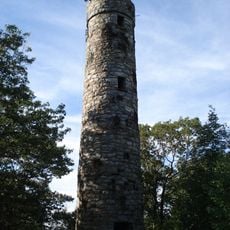
Poet's Seat Tower, Stone observation tower in Greenfield, Massachusetts

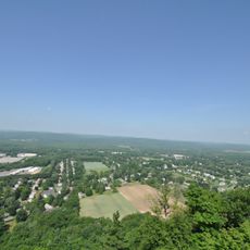
Poet's Seat Tower is a sandstone observation tower on Rocky Mountain in Greenfield, Massachusetts, with several floors connected by an internal staircase and arched windows on each level. From the top, visitors look out west over Greenfield and east toward the Connecticut Valley and the town of Montague.

A wooden tower stood on this spot from 1879 until it was replaced by the current stone structure in 1912. The Greenfield Rural Club led the effort to build the new tower, turning the site into a lasting public landmark.

The tower takes its name from the poet Frederick Goddard Tuckerman, who used this rocky outcrop as a writing spot in the mid-1800s. Visitors familiar with his poetry can look out over the same landscape he wrote about.

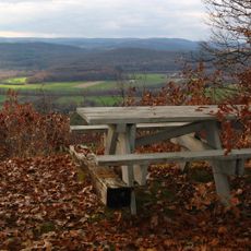
A paved path leads up to the tower, and stone benches near the base offer a place to stop before or after climbing. Inside, the staircase is narrow and steep, so visitors with limited mobility should keep that in mind.

The sandstone used to build the tower was quarried directly from Rocky Mountain, the hill on which it stands. The structure was essentially carved out of the same ground it sits on.

The community of curious travelers

AroundUs brings together thousands of curated places, local tips, and hidden gems, enriched daily by 60,000 contributors worldwide.

Start exploring
Location
GPS coordinates
42.59465,-72.58653
Latest update
March 3, 2026 14:04
Around this place
French King Bridge
United States of America

French King Bridge

7.4 km
Historic Deerfield
United States of America

Historic Deerfield

5.5 km
Connecticut River Greenway State Park
United States of America

Connecticut River Greenway State Park

3.9 km
Canalside Rail Trail Bridge
United States of America

Canalside Rail Trail Bridge

2 km
Bardwell's Ferry Bridge
United States of America

Bardwell's Ferry Bridge

8.7 km
General Pierce Bridge
United States of America

General Pierce Bridge

1.7 km
Turners Falls Road Bridge
United States of America

Turners Falls Road Bridge

2.6 km
Dedic Site
United States of America

Dedic Site

4.8 km
Pocumtuck Ridge Trail
United States of America

Pocumtuck Ridge Trail

7.9 km
Main Street Historic District
United States of America

Main Street Historic District

1.5 km
Turners Falls–Gill Bridge
United States of America

Turners Falls–Gill Bridge

3.4 km
Leavitt-Hovey House
United States of America

Leavitt-Hovey House

1.3 km
Springfield Terminal railroad bridge, Deerfield
United States of America

Springfield Terminal railroad bridge, Deerfield

4.4 km
Garden Theater Block
United States of America

Garden Theater Block

1.4 km
Bernardston Congregational Unitarian Church
United States of America

Bernardston Congregational Unitarian Church

9 km
Old Tavern Farm
United States of America

Old Tavern Farm

5.1 km
United States Post Office–Greenfield Main
United States of America

United States Post Office–Greenfield Main

1.2 km
Turners Falls Historic District
United States of America

Turners Falls Historic District

2.9 km
Powers Institute Historic District
United States of America

Powers Institute Historic District

8.9 km
Gill Center Historic District
United States of America

Gill Center Historic District

8.8 km
East Main-High Street Historic District
United States of America

East Main-High Street Historic District

1.1 km
Shelburne Free Public Library
United States of America

Shelburne Free Public Library

8.4 km
Massaemett Mountain
United States of America

Massaemett Mountain

11 km
Montague Center Historic District
United States of America

Montague Center Historic District

7.9 km
Great Falls Discovery Center
United States of America

Great Falls Discovery Center

3.1 km
Montague City Covered Bridge
United States of America

Montague City Covered Bridge

1.7 km
Guiding Star Grange
United States of America

Guiding Star Grange

1.8 km
East Shelburne Cemetery
United States of America

East Shelburne Cemetery

7 km
Show the full map
Reviews
Share your experience

No review yet

Discussions
Start a discussion...

No discussion yet

« Poet's Seat Tower - Stone observation tower in Greenfield, Massachusetts » is provided by Around Us (aroundus.com). Images and texts are derived from Wikimedia project under a Creative Commons license. You are allowed to copy, distribute, and modify copies of this page, under the conditions set by the license, as long as this note is clearly visible.

Discover hidden gems everywhere you go!

From secret cafés to breathtaking viewpoints, skip the crowded tourist spots and find places that match your style. Our app makes it easy with voice search, smart filtering, route optimization, and insider tips from travelers worldwide. Download now for the complete mobile experience.

Around Us App Screenshot

A unique approach to discovering new places

Le Figaro

All the places worth exploring

France Info

A tailor-made excursion in just a few clicks

20 Minutes

Around Us
Travel Guide & Maps
Download

Send to your phone

QR Code
1

Open the camera app on your mobile.

2

Point at the QR code with your camera. A notification will appear.

3

Tap the notification to open the link.