Enable Location

We need your location to show you interesting places around you

Discover nearby places

Find interesting locations and hidden gems around you

Precise directions

Get accurate directions and distances to places

Your location is never shared with other users. It's only used when you tap the location button.

Sunderland Bridge

Log in to your account

Start exploring — it's free

Trusted by 61,422 travelers worldwide

Continue with Google
Continue with Apple
or

We will send you a code to connect

By continuing, you accept our Terms and Conditions and our Privacy Policy

Check your inbox

We've sent a pincode in your inbox. Please enter the code below.

Sunderland Bridge

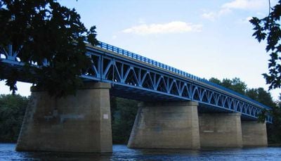
Sunderland Bridge, Road bridge in South Deerfield, Massachusetts, United States.

Description

Sunderland Bridge is a road bridge that crosses the Connecticut River between South Deerfield and Sunderland in western Massachusetts. It uses a deck truss design to carry vehicular traffic over roughly 1,200 feet of river.

History

The original bridge was destroyed during a major flood in 1936, leading to its reconstruction in 1937. The structure received significant updates in the 1990s to reinforce and modernize it.

Culture

The bridge's structural elements represent mid-20th century American engineering practices, with its design reflecting the technological capabilities of that period.

Practical

The bridge carries Massachusetts Route 116 and serves as a key transportation link for residents on both sides of the river. It remains open year-round and handles daily traffic between the two communities.

Did you know?

The bridge's metal deck truss configuration demonstrates efficient engineering principles, using interconnected structural elements to distribute weight across its span.

Location
GPS coordinates
42.46750,-72.58500
Latest update
December 13, 2025 17:00

AroundUs brings together thousands of curated places, local tips, and hidden gems, enriched daily by 60,000 contributors worldwide. Discover all places nearby (Massachusetts).

Around this place
Buttonball Tree
United States of America

Buttonball Tree

561 m
Sugarloaf Mountain
United States of America

Sugarloaf Mountain

666 m
Mount Toby
United States of America

Mount Toby

4.5 km
Historic Deerfield
United States of America

Historic Deerfield

9 km
Mount Sugarloaf State Reservation
United States of America

Mount Sugarloaf State Reservation

656 m
United States of America

New England Peace Pagoda

8.5 km
John W. Lederle Graduate Research Center
United States of America

John W. Lederle Graduate Research Center

9.4 km
Rattlesnake Gutter
United States of America

Rattlesnake Gutter

7.3 km
Ellis Drive Historical Area
United States of America

Ellis Drive Historical Area

9.5 km
Pocumtuck Ridge Trail
United States of America

Pocumtuck Ridge Trail

6.3 km
William M. Cashin House
United States of America

William M. Cashin House

9.4 km
Upper Main Street Historic District
United States of America

Upper Main Street Historic District

9 km
North Hadley Historic District
United States of America

North Hadley Historic District

8.7 km
Cushman Village Historic District
United States of America

Cushman Village Historic District

8.5 km
Marston Hall
United States of America

Marston Hall

9.4 km
North Amherst Center Historic District
United States of America

North Amherst Center Historic District

7.9 km
North Leverett, Massachusetts
United States of America

North Leverett, Massachusetts

8.9 km
Whately Center Historic District
United States of America

Whately Center Historic District

5.3 km
West Whately Historic District
United States of America

West Whately Historic District

8.6 km
Bradstreet Historic District
United States of America

Bradstreet Historic District

6.9 km
East Leverett Historic District
United States of America

East Leverett Historic District

9 km
Robert Frost Trail
United States of America

Robert Frost Trail

4.5 km
Leverett Center Historic District
United States of America

Leverett Center Historic District

6.5 km
Montague Center Historic District
United States of America

Montague Center Historic District

8.6 km
North Hatfield Historic District
United States of America

North Hatfield Historic District

7.2 km
Mount Toby Fire Tower
United States of America

Mount Toby Fire Tower

4.5 km
Elizabeth McNamara House
United States of America

Elizabeth McNamara House

9.3 km
Anna M. Johnson House
United States of America

Anna M. Johnson House

9.4 km
Show the full map
« Sunderland Bridge - Road bridge in South Deerfield, Massachusetts, United States » is provided by Around Us (aroundus.com). Images and texts are derived from Wikimedia project under a Creative Commons license. You are allowed to copy, distribute, and modify copies of this page, under the conditions set by the license, as long as this note is clearly visible.

Discover hidden gems everywhere you go!

From secret cafés to breathtaking viewpoints, skip the crowded tourist spots and find places that match your style. Our app makes it easy with voice search, smart filtering, route optimization, and insider tips from travelers worldwide. Download now for the complete mobile experience.

Around Us App Screenshot

A unique approach to discovering new places

Le Figaro

All the places worth exploring

France Info

A tailor-made excursion in just a few clicks

20 Minutes

Around Us
Travel Guide & Maps
Download

Send to your phone

QR Code
1

Open the camera app on your mobile.

2

Point at the QR code with your camera. A notification will appear.

3

Tap the notification to open the link.