Sugarloaf Mountain

Log in to your account

AroundUs is a community-driven map of interesting places, built by curious explorers like you. It grows with every review, story, and photo you share.
Connect to save your favorite spots, contribute locations, and create personalized routes.
Continue with Google
Continue with Apple
Continue with X
Continue with Facebook
Continue with email
By continuing, you accept our Terms and Conditions and our Privacy Policy
Create an account
Add to collection
Map
Suggest a change
Share

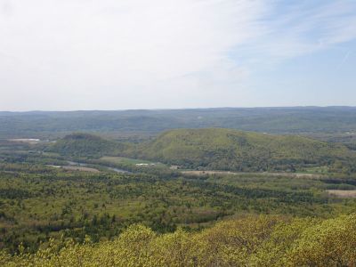
Sugarloaf Mountain, Summit in South Deerfield, Massachusetts, United States.

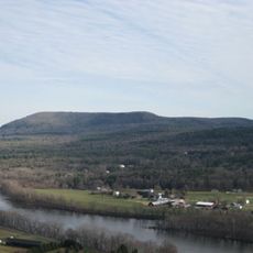
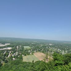
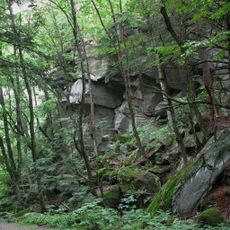
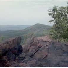
Sugarloaf Mountain is a summit in South Deerfield composed of layered sedimentary rock formations. The peak rises above the surrounding landscape and reveals distinct bands of quartzite and sandstone through its exposed slopes.

The mountain formed hundreds of millions of years ago when shallow seas covered this region. Those ancient waters left behind the sediment layers that now make up the peak.

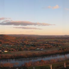
Native American peoples valued this summit as a lookout point across the Connecticut River valley. The elevated position made it useful for monitoring activities and movement across the landscape below.

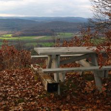
Marked trails lead to the summit from multiple starting points on both the eastern and western slopes. Visitors can choose different routes depending on their preferred access point and hiking ability.

The exposed layers of quartzite and sandstone at this location clearly show the geological processes that shaped Massachusetts. These visible rock formations offer a direct glimpse into how the region changed over deep time.

Location: Massachusetts

Made from material: sedimentary rock

GPS coordinates: 42.47009,-72.59231

Latest update: December 10, 2025 15:50

Photos
Around this place
Buttonball Tree
United States of America

Buttonball Tree

1.2 km
Mount Toby
United States of America

Mount Toby

4.9 km
Historic Deerfield
United States of America

Historic Deerfield

8.6 km
Mount Sugarloaf State Reservation
United States of America

Mount Sugarloaf State Reservation

21 m
United States of America

New England Peace Pagoda

8.9 km
Sunderland Bridge
United States of America

Sunderland Bridge

666 m
Dedic Site
United States of America

Dedic Site

9.5 km
Rattlesnake Gutter
United States of America

Rattlesnake Gutter

7.8 km
Pocumtuck Ridge Trail
United States of America

Pocumtuck Ridge Trail

6 km
William M. Cashin House
United States of America

William M. Cashin House

9.9 km
Upper Main Street Historic District
United States of America

Upper Main Street Historic District

9.2 km
North Hadley Historic District
United States of America

North Hadley Historic District

9 km
Cushman Village Historic District
United States of America

Cushman Village Historic District

9.1 km
Marston Hall
United States of America

Marston Hall

9.9 km
North Amherst Center Historic District
United States of America

North Amherst Center Historic District

8.4 km
North Leverett, Massachusetts
United States of America

North Leverett, Massachusetts

9.2 km
Conway Center Historic District
United States of America

Conway Center Historic District

9.6 km
Whately Center Historic District
United States of America

Whately Center Historic District

5 km
West Whately Historic District
United States of America

West Whately Historic District

8.2 km
Bradstreet Historic District
United States of America

Bradstreet Historic District

7.2 km
East Leverett Historic District
United States of America

East Leverett Historic District

9.7 km
Robert Frost Trail
United States of America

Robert Frost Trail

4.9 km
Leverett Center Historic District
United States of America

Leverett Center Historic District

7.1 km
Montague Center Historic District
United States of America

Montague Center Historic District

8.6 km
North Hatfield Historic District
United States of America

North Hatfield Historic District

7.3 km
Mount Toby Fire Tower
United States of America

Mount Toby Fire Tower

4.9 km
Elizabeth McNamara House
United States of America

Elizabeth McNamara House

9.9 km
Anna M. Johnson House
United States of America

Anna M. Johnson House

10 km
Show the full map
Reviews

Visited this place? Tap the stars to rate it and share your experience / photos with the community! Try now! You can cancel it anytime.

« Sugarloaf Mountain - Summit in South Deerfield, Massachusetts, United States » is provided by Around Us (aroundus.com). Images and texts are derived from Wikimedia project under a Creative Commons license. You are allowed to copy, distribute, and modify copies of this page, under the conditions set by the license, as long as this note is clearly visible.

Discover hidden gems everywhere you go!

From secret cafés to breathtaking viewpoints, skip the crowded tourist spots and find places that match your style. Our app makes it easy with voice search, smart filtering, route optimization, and insider tips from travelers worldwide. Download now for the complete mobile experience.

Around Us App Screenshot

A unique approach to discovering new places

Le Figaro

All the places worth exploring

France Info

A tailor-made excursion in just a few clicks

20 Minutes