Tully Trail

Log in to your account

AroundUs is a community-driven map of interesting places, built by curious explorers like you. It grows with every review, story, and photo you share.
Connect to save your favorite spots, contribute locations, and create personalized routes.
Continue with Google
Continue with Apple
Continue with X
Continue with Facebook
Continue with email
By continuing, you accept our Terms and Conditions and our Privacy Policy
Create an account
Add to collection
Map
Suggest a change
Share

Tully Trail, Circular hiking trail in Franklin County, Massachusetts

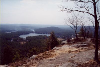
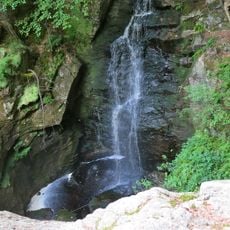
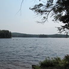
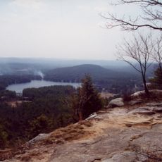
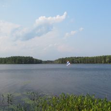
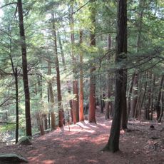
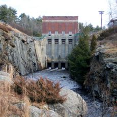
Tully Trail is a circular hiking route in Franklin County that loops around a valley through forested hills and open areas. The path connects several waterfalls, mountain peaks, and a lake while traversing changing terrain throughout its length.

The trail system was developed through conservation efforts by regional land trusts working to protect the North Quabbin area. These organizations established and maintained the route to preserve natural resources for future generations.

This trail network joins with the Metacomet-Monadnock Trail, creating connections between Massachusetts natural spaces and extending recreational opportunities toward New Hampshire.

Bring a map or navigation tool since some sections can be confusing even with trail markings. Sturdy shoes and preparation for changing terrain will help you have a comfortable day on the path.

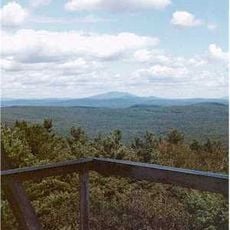
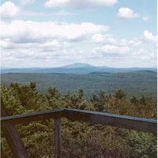
The route climbs to a mountain peak offering views of surrounding land, then descends significantly to reach a river below. This dramatic elevation change creates different plant and animal environments within a single walk.

Location: Franklin County

GPS coordinates: 42.65170,-72.21220

Latest update: December 14, 2025 09:43

Photos
Around this place
Harvard Forest
United States of America

Harvard Forest

13.5 km
Doane's Falls
United States of America

Doane's Falls

903 m
Royalston Falls
United States of America

Royalston Falls

7.6 km
Tully Lake
United States of America

Tully Lake

836 m
Tully Mountain
United States of America

Tully Mountain

3.1 km
Mount Grace
United States of America

Mount Grace

12.5 km
Rhododendron State Park
United States of America

Rhododendron State Park

14.9 km
Lake Dennison Recreation Area
United States of America

Lake Dennison Recreation Area

11.4 km
Templeton Developmental Center
United States of America

Templeton Developmental Center

9.6 km
Jacobs Hill
United States of America

Jacobs Hill

2.7 km
Mount Grace State Forest
United States of America

Mount Grace State Forest

12.1 km
United States of America

Spirit Falls

2 km
Whitaker-Clary House
United States of America

Whitaker-Clary House

15 km
Third Fitzwilliam Meetinghouse
United States of America

Third Fitzwilliam Meetinghouse

15.3 km
Orange Center Historic District
United States of America

Orange Center Historic District

10.5 km
Mount Grace Land Conservation Trust
United States of America

Mount Grace Land Conservation Trust

3.3 km
Old Town Hall
United States of America

Old Town Hall

6.6 km
Old Centre Historic District
United States of America

Old Centre Historic District

14.2 km
Baldwinville Village Historic District
United States of America

Baldwinville Village Historic District

12.2 km
Phillipston Center Historic District
United States of America

Phillipston Center Historic District

12.8 km
Royalston Common Historic District
United States of America

Royalston Common Historic District

3.5 km
Grand Army of the Republic Hall
United States of America

Grand Army of the Republic Hall

10.4 km
Richmond School House No. 6
United States of America

Richmond School House No. 6

12.6 km
Richmond Town Hall
United States of America

Richmond Town Hall

13.2 km
Winchendon Village Historic District
United States of America

Winchendon Village Historic District

13.7 km
Birch Hill Dam
United States of America

Birch Hill Dam

7.7 km
Warwick Fire Tower
United States of America

Warwick Fire Tower

12.5 km
Tully Cemetery
United States of America

Tully Cemetery

3.4 km
Show the full map
Reviews

Visited this place? Tap the stars to rate it and share your experience / photos with the community! Try now! You can cancel it anytime.

« Tully Trail - Circular hiking trail in Franklin County, Massachusetts » is provided by Around Us (aroundus.com). Images and texts are derived from Wikimedia project under a Creative Commons license. You are allowed to copy, distribute, and modify copies of this page, under the conditions set by the license, as long as this note is clearly visible.

Discover hidden gems everywhere you go!

From secret cafés to breathtaking viewpoints, skip the crowded tourist spots and find places that match your style. Our app makes it easy with voice search, smart filtering, route optimization, and insider tips from travelers worldwide. Download now for the complete mobile experience.

Around Us App Screenshot

A unique approach to discovering new places

Le Figaro

All the places worth exploring

France Info

A tailor-made excursion in just a few clicks

20 Minutes