Enable Location

We need your location to show you interesting places around you

Discover nearby places

Find interesting locations and hidden gems around you

Precise directions

Get accurate directions and distances to places

Your location is never shared with other users. It's only used when you tap the location button.

Bear Island Light

Log in to your account

Start exploring — it's free

Trusted by 61,641 travelers worldwide

Continue with Google
Continue with Apple
or

We will send you a code to connect

By continuing, you accept our Terms and Conditions and our Privacy Policy

Check your inbox

We've sent a pincode in your inbox. Please enter the code below.

Bear Island Light

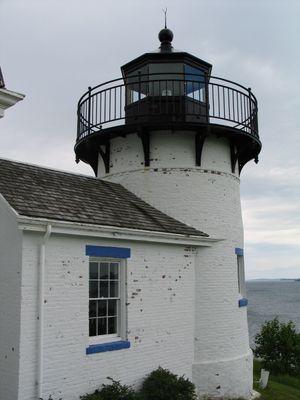
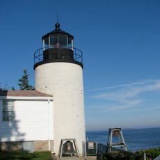
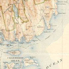
Bear Island Light, Maritime lighthouse in Cranberry Isles, United States.

Description

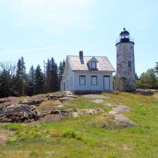
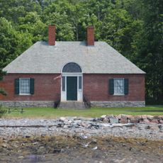
Bear Island Light is a lighthouse positioned at the southern entrance to Somes Sound near Mount Desert Island. The brick tower stands about 31 feet (9 meters) tall on an 11-acre island surrounded entirely by water.

History

The original structure was built in 1839 following approval by President Martin Van Buren, though the current tower dates from a reconstruction in 1889. This rebuilding allowed the light to continue serving vessels navigating the rocky Maine coast.

Culture

The lighthouse served as a home for lighthouse keepers and their families across generations, shaping life on the isolated island. This continuous human presence created a unique community tied to maritime navigation and survival.

Practical

The lighthouse now serves as a private residence and is viewable from the water, though it can only be reached by boat from surrounding areas. Visitors typically observe it from the water rather than visiting the island itself, making a boat tour the best way to see it.

Did you know?

The structure sits on federal park land but operates under private lease, functioning as both a residence and a working navigation aid simultaneously. This unusual dual role makes it one of the few inhabited maritime structures that continues to serve its original purpose.

Location
GPS coordinates
44.28343,-68.26991
Latest update
December 13, 2025 11:40

AroundUs brings together thousands of curated places, local tips, and hidden gems, enriched daily by 60,000 contributors worldwide. Discover all places nearby (Cranberry Isles).

Around this place
Cadillac Mountain
United States of America

Cadillac Mountain

8.6 km
Bass Harbor Head Light
United States of America

Bass Harbor Head Light

8.7 km
Asticou Inn
United States of America

Asticou Inn

2.4 km
Blackwoods Campground
United States of America

Blackwoods Campground

6 km
Abbe Museum
United States of America

Abbe Museum

9.9 km
Otter Cliffs Radio Station
United States of America

Otter Cliffs Radio Station

6.9 km
Baker Island Light
United States of America

Baker Island Light

7.4 km
Carriage Paths, Bridges and Gatehouses
United States of America

Carriage Paths, Bridges and Gatehouses

8.5 km
Highseas
United States of America

Highseas

10.6 km
Asticou Azalea Garden
United States of America

Asticou Azalea Garden

2.6 km
Seawall Campground
United States of America

Seawall Campground

5.5 km
Mira Monte Inn
United States of America

Mira Monte Inn

12.4 km
St. Mary's-By-The-Sea
United States of America

St. Mary's-By-The-Sea

1.4 km
Islesford Historical Museum and Blue Duck Ships Store
United States of America

Islesford Historical Museum and Blue Duck Ships Store

3.4 km
Jesup Memorial Library
United States of America

Jesup Memorial Library

12.5 km
Ivy Manor Inn
United States of America

Ivy Manor Inn

12.7 km
33 Ledgelawn Avenue
United States of America

33 Ledgelawn Avenue

12.4 km
Reverie Cove
United States of America

Reverie Cove

12.7 km
Ellsworth City Hall
United States of America

Ellsworth City Hall

4.6 km
United States of America

Union Church of Northeast Harbor

2.1 km
Saint Jude's Episcopal Church
United States of America

Saint Jude's Episcopal Church

2.2 km
Bass Harbor Memorial Library
United States of America

Bass Harbor Memorial Library

8.3 km
Abbe Museum
United States of America

Abbe Museum

12.6 km
Bubble Pond Bridge
United States of America

Bubble Pond Bridge

7.7 km
Beech Mountain Lookout Tower
United States of America

Beech Mountain Lookout Tower

6.7 km
Seawall Campground Ranger Station
United States of America

Seawall Campground Ranger Station

5.5 km
Cobblestone Bridge
United States of America

Cobblestone Bridge

3.4 km
Deer Brook Bridge
United States of America

Deer Brook Bridge

6.4 km
Show the full map
« Bear Island Light - Maritime lighthouse in Cranberry Isles, United States » is provided by Around Us (aroundus.com). Images and texts are derived from Wikimedia project under a Creative Commons license. You are allowed to copy, distribute, and modify copies of this page, under the conditions set by the license, as long as this note is clearly visible.

Discover hidden gems everywhere you go!

From secret cafés to breathtaking viewpoints, skip the crowded tourist spots and find places that match your style. Our app makes it easy with voice search, smart filtering, route optimization, and insider tips from travelers worldwide. Download now for the complete mobile experience.

Around Us App Screenshot

A unique approach to discovering new places

Le Figaro

All the places worth exploring

France Info

A tailor-made excursion in just a few clicks

20 Minutes

Around Us
Travel Guide & Maps
Download

Send to your phone

QR Code
1

Open the camera app on your mobile.

2

Point at the QR code with your camera. A notification will appear.

3

Tap the notification to open the link.