Log in to your account

AroundUs is a community-driven map of interesting places, built by curious explorers like you. It grows with every review, story, and photo you share.
Connect to save your favorite spots, contribute locations, and create personalized routes.
Continue with Google
Continue with Apple
Continue with X
Continue with Facebook
Continue with email
By continuing, you accept our Terms and Conditions and our Privacy Policy
Create an account
Add to collection
Map
Suggest a change
Share

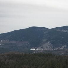
Bayle Mountain, Mountain summit in Ossipee, New Hampshire, US

Bayle Mountain is a summit near Ossipee that rises 1,853 feet (564 meters) above Conner Pond with exposed rock ledges and forested sections along its paths. The ascent covers about 3 miles (5 kilometers) round trip and passes through boulder fields and open forest areas.

The mountain formed over long geological periods as part of the Ossipee Mountain Range in New England. A forest fire in 2015 exposed additional rock formations and altered the landscape's natural appearance.

The summit keeps a visitor register where hikers write down their names and thoughts, creating a shared record of outdoor journeys. This tradition connects people who visit the mountain through their personal reflections.

Sturdy hiking boots and weather-appropriate clothing are essential due to the rocky terrain and changing conditions based on the season. Checking the forecast before starting and hiking in early hours helps ensure you reach the summit with daylight remaining.

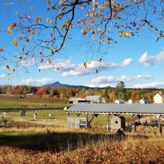
From the rocky summit, hikers see Ossipee Lake, Silver Lake, and the connected ridges of the surrounding mountain range spread across the landscape. This wide vista over the lakes and mountains makes the climb memorable.

Location: New Hampshire

GPS coordinates: 43.78346,-71.25182

Latest update: December 14, 2025 14:44

Photos
Around this place
Castle in the Clouds
United States of America

Castle in the Clouds

8.3 km
Madison Boulder
United States of America

Madison Boulder

17.8 km
United States of America

Mount Shaw

4.8 km
Joy Farm
United States of America

Joy Farm

15.7 km
United States of America

Camp Cody

9.2 km
Barnstormers Theatre
United States of America

Barnstormers Theatre

8.6 km
Swallow Boathouse
United States of America

Swallow Boathouse

15.8 km
Mount Roberts
United States of America

Mount Roberts

6.7 km
United States of America

Hemenway State Forest

12 km
Whittier Bridge
United States of America

Whittier Bridge

5.4 km
Carroll County Court House
United States of America

Carroll County Court House

15.4 km
Durgin Bridge
United States of America

Durgin Bridge

12.1 km
Capt. Enoch Remick House
United States of America

Capt. Enoch Remick House

8.7 km
Windermere
United States of America

Windermere

18.2 km
White Meetinghouse
United States of America

White Meetinghouse

16.5 km
Tuftonboro United Methodist Church
United States of America

Tuftonboro United Methodist Church

10.1 km
Town Hall
United States of America

Town Hall

15.2 km
North Sandwich Meeting House
United States of America

North Sandwich Meeting House

12.6 km
Moultonborough Town House
United States of America

Moultonborough Town House

12.4 km
Chocorua Lake Basin Historic District
United States of America

Chocorua Lake Basin Historic District

13.1 km
High, Church and Gould Streets Historic District
United States of America

High, Church and Gould Streets Historic District

12.4 km
Bradbury Jewell House
United States of America

Bradbury Jewell House

16.7 km
Cook Memorial Library
United States of America

Cook Memorial Library

8.5 km
Hansen's Annex
United States of America

Hansen's Annex

15.3 km
Lower Corner Historic District
United States of America

Lower Corner Historic District

13 km
Remick Country Doctor Museum & Farm
United States of America

Remick Country Doctor Museum & Farm

8.5 km
Mount Whittier
United States of America

Mount Whittier

2.9 km
Center Sandwich Historic District
United States of America

Center Sandwich Historic District

15.3 km
Show the full map
Reviews

Visited this place? Tap the stars to rate it and share your experience / photos with the community! Try now! You can cancel it anytime.

« Bayle Mountain - Mountain summit in Ossipee, New Hampshire, US » is provided by Around Us (aroundus.com). Images and texts are derived from Wikimedia project under a Creative Commons license. You are allowed to copy, distribute, and modify copies of this page, under the conditions set by the license, as long as this note is clearly visible.

Discover hidden gems everywhere you go!

From secret cafés to breathtaking viewpoints, skip the crowded tourist spots and find places that match your style. Our app makes it easy with voice search, smart filtering, route optimization, and insider tips from travelers worldwide. Download now for the complete mobile experience.

Around Us App Screenshot

A unique approach to discovering new places

Le Figaro

All the places worth exploring

France Info

A tailor-made excursion in just a few clicks

20 Minutes