Enable Location

We need your location to show you interesting places around you

Discover nearby places

Find interesting locations and hidden gems around you

Precise directions

Get accurate directions and distances to places

Your location is never shared with other users. It's only used when you tap the location button.

Whittier Bridge

Log in to your account

Start exploring — it's free

Trusted by 61,367 travelers worldwide

Continue with Google
Continue with Apple
or

We will send you a code to connect

By continuing, you accept our Terms and Conditions and our Privacy Policy

Check your inbox

We've sent a pincode in your inbox. Please enter the code below.

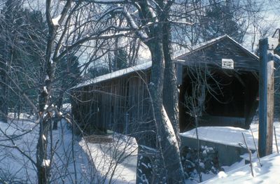
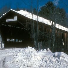
Whittier Bridge, Wooden covered bridge in Ossipee, New Hampshire, United States.

Description

Whittier Bridge is a covered wooden structure that crosses the Bearcamp River using a Paddleford truss design. Its sides feature shorter board walls rather than full-height enclosure, creating openings that let people see through to the water below.

History

This structure was built in 1870 to replace a crossing destroyed by severe floods. Earlier bridges at this site dated back to 1792, when the first settlers arrived in the area.

Culture

The bridge takes its name from poet John Greenleaf Whittier, who spent summers at the nearby West Ossipee Hotel during the 1870s. His presence in the area left an impression that locals still remember when they speak of this crossing.

Practical

You will find this bridge west of Route 16 at West Ossipee Village along old Route 125. It is now open only to foot traffic following a comprehensive restoration completed in 2022.

Did you know?

What sets this bridge apart is its shorter vertical board siding that stops partway up instead of reaching full height. This distinctive design lets walkers peek at the river while moving through the covered structure.

Location
GPS coordinates
43.82222,-71.21194
Latest update
December 14, 2025 17:40

AroundUs brings together thousands of curated places, local tips, and hidden gems, enriched daily by 60,000 contributors worldwide. Discover all places nearby (New Hampshire).

Around this place
Castle in the Clouds
United States of America

Castle in the Clouds

13.7 km
Mount Chocorua
United States of America

Mount Chocorua

15.5 km
Madison Boulder
United States of America

Madison Boulder

12.7 km
United States of America

Mount Shaw

10.1 km
Joy Farm
United States of America

Joy Farm

10.6 km
United States of America

Camp Cody

5.5 km
Barnstormers Theatre
United States of America

Barnstormers Theatre

6.1 km
Mount Roberts
United States of America

Mount Roberts

11.7 km
United States of America

Bayle Mountain

5.4 km
United States of America

Hemenway State Forest

10 km
Carroll County Court House
United States of America

Carroll County Court House

17 km
Durgin Bridge
United States of America

Durgin Bridge

12.8 km
Capt. Enoch Remick House
United States of America

Capt. Enoch Remick House

6.4 km
Lord's Hill Historic District
United States of America

Lord's Hill Historic District

18.4 km
White Meetinghouse
United States of America

White Meetinghouse

11.7 km
Tuftonboro United Methodist Church
United States of America

Tuftonboro United Methodist Church

14.1 km
Town Hall
United States of America

Town Hall

18.3 km
North Sandwich Meeting House
United States of America

North Sandwich Meeting House

13.1 km
Moultonborough Town House
United States of America

Moultonborough Town House

17 km
Chocorua Lake Basin Historic District
United States of America

Chocorua Lake Basin Historic District

8.9 km
High, Church and Gould Streets Historic District
United States of America

High, Church and Gould Streets Historic District

16.2 km
Bradbury Jewell House
United States of America

Bradbury Jewell House

15.5 km
Cook Memorial Library
United States of America

Cook Memorial Library

6 km
Hansen's Annex
United States of America

Hansen's Annex

18.3 km
Lower Corner Historic District
United States of America

Lower Corner Historic District

16.5 km
Remick Country Doctor Museum & Farm
United States of America

Remick Country Doctor Museum & Farm

6.1 km
Mount Whittier
United States of America

Mount Whittier

4.1 km
Center Sandwich Historic District
United States of America

Center Sandwich Historic District

18.4 km
Show the full map
« Whittier Bridge - Wooden covered bridge in Ossipee, New Hampshire, United States » is provided by Around Us (aroundus.com). Images and texts are derived from Wikimedia project under a Creative Commons license. You are allowed to copy, distribute, and modify copies of this page, under the conditions set by the license, as long as this note is clearly visible.

Discover hidden gems everywhere you go!

From secret cafés to breathtaking viewpoints, skip the crowded tourist spots and find places that match your style. Our app makes it easy with voice search, smart filtering, route optimization, and insider tips from travelers worldwide. Download now for the complete mobile experience.

Around Us App Screenshot

A unique approach to discovering new places

Le Figaro

All the places worth exploring

France Info

A tailor-made excursion in just a few clicks

20 Minutes

Around Us
Travel Guide & Maps
Download

Send to your phone

QR Code
1

Open the camera app on your mobile.

2

Point at the QR code with your camera. A notification will appear.

3

Tap the notification to open the link.