Enable Location

We need your location to show you interesting places around you

Discover nearby places

Find interesting locations and hidden gems around you

Precise directions

Get accurate directions and distances to places

Your location is never shared with other users. It's only used when you tap the location button.

Battle of Lexington State Historic Site

Log in to your account

Start exploring — it's free

Trusted by 61,900 travelers worldwide

Continue with Google
Continue with Apple
or

We will send you a code to connect

By continuing, you accept our Terms and Conditions and our Privacy Policy

Check your inbox

We've sent a pincode in your inbox. Please enter the code below.

Battle of Lexington State Historic Site

Battle of Lexington State Historic Site, Civil War museum in Lexington, Missouri, US

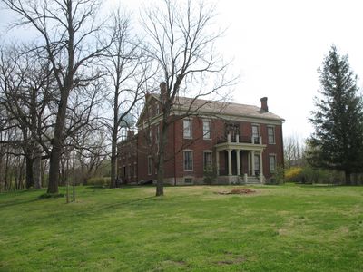
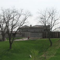
The Battle of Lexington State Historic Site is a museum in Missouri preserving a historic house, walking trails, and exhibits from the 1861 fighting. The grounds allow visitors to walk through the battlefield and see how the landscape shaped the conflict.

In September 1861, this site saw fighting between troops led by Major General Sterling Price and Union soldiers commanded by Colonel James Mulligan. The battle was one of the early Civil War engagements in the western region.

The house displays bullet holes and damage from the fighting, showing how the conflict directly affected civilian homes in the area. Visitors can see these marks and understand how close the battle came to everyday life.

The site has a visitor center with guided tours, displays, and walking paths that are easy to explore on foot. Mobility assistance options like electric off-road chairs are available to help visitors access the grounds.

Soldiers used hemp bales as moving fortifications during the fighting, rolling them forward to create protection. This creative tactic shows how fighters adapted to the conditions they faced.

The community of curious travelers

AroundUs brings together thousands of curated places, local tips, and hidden gems, enriched daily by 60,000 contributors worldwide.

Start exploring
GPS coordinates
39.19250,-93.87611
Latest update
December 12, 2025 07:55
Around this place
Fort Osage
United States of America

Fort Osage

27.3 km
Powell Gardens
United States of America

Powell Gardens

38.5 km
Hall of Waters
United States of America

Hall of Waters

34.1 km
Cumberland Presbyterian Church
United States of America

Cumberland Presbyterian Church

876 m
Lafayette County Courthouse
United States of America

Lafayette County Courthouse

909 m
Sibley Railroad Bridge
United States of America

Sibley Railroad Bridge

26.2 km
Wyman School
United States of America

Wyman School

34.8 km
Odessa Ice Cream Company Building
United States of America

Odessa Ice Cream Company Building

23.2 km
Waddell House
United States of America

Waddell House

966 m
Highland Avenue Historic District
United States of America

Highland Avenue Historic District

902 m
Theodore Gosewisch House
United States of America

Theodore Gosewisch House

4.1 km
First Methodist Church
United States of America

First Methodist Church

34.5 km
Ligon Apartments
United States of America

Ligon Apartments

34.3 km
Carroll County Court House
United States of America

Carroll County Court House

37.6 km
Farmers Bank Building
United States of America

Farmers Bank Building

21.1 km
Wilcoxson and Company Bank
United States of America

Wilcoxson and Company Bank

37.6 km
Excelsior Springs Hall of Waters Commercial East Historic District
United States of America

Excelsior Springs Hall of Waters Commercial East Historic District

34.3 km
Ray County Courthouse
United States of America

Ray County Courthouse

13 km
Watkins House
United States of America

Watkins House

12.9 km
Excelsior Springs Hall of Waters Commercial West Historic District
United States of America

Excelsior Springs Hall of Waters Commercial West Historic District

35.3 km
Old Neighborhoods Historic District
United States of America

Old Neighborhoods Historic District

786 m
United States Post Office
United States of America

United States Post Office

37.8 km
Missouri City Savings Bank Building and Meeting Hall
United States of America

Missouri City Savings Bank Building and Meeting Hall

36.4 km
Dougherty Auditorium
United States of America

Dougherty Auditorium

13 km
Ray County Poor Farm
United States of America

Ray County Poor Farm

13.2 km
Marjorie Powell Allen Chapel
United States of America

Marjorie Powell Allen Chapel

38.3 km
Russell Sunflower Patch
United States of America

Russell Sunflower Patch

25.3 km
Waverly Bridge
United States of America

Waverly Bridge

31.5 km
Show the full map
« Battle of Lexington State Historic Site - Civil War museum in Lexington, Missouri, US » is provided by Around Us (aroundus.com). Images and texts are derived from Wikimedia project under a Creative Commons license. You are allowed to copy, distribute, and modify copies of this page, under the conditions set by the license, as long as this note is clearly visible.

Discover hidden gems everywhere you go!

From secret cafés to breathtaking viewpoints, skip the crowded tourist spots and find places that match your style. Our app makes it easy with voice search, smart filtering, route optimization, and insider tips from travelers worldwide. Download now for the complete mobile experience.

Around Us App Screenshot

A unique approach to discovering new places

Le Figaro

All the places worth exploring

France Info

A tailor-made excursion in just a few clicks

20 Minutes

Around Us
Travel Guide & Maps
Download

Send to your phone

QR Code
1

Open the camera app on your mobile.

2

Point at the QR code with your camera. A notification will appear.

3

Tap the notification to open the link.