Enable Location

We need your location to show you interesting places around you

Discover nearby places

Find interesting locations and hidden gems around you

Precise directions

Get accurate directions and distances to places

Your location is never shared with other users. It's only used when you tap the location button.

Wyman School

Log in to your account

Start exploring — it's free

Trusted by 61,984 travelers worldwide

Continue with Google
Continue with Apple
or

We will send you a code to connect

By continuing, you accept our Terms and Conditions and our Privacy Policy

Check your inbox

We've sent a pincode in your inbox. Please enter the code below.

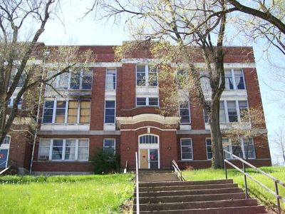
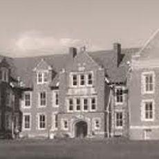
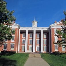
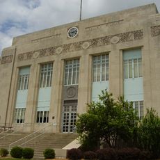
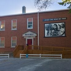
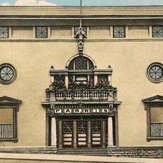
Wyman School, Historic school building in Excelsior Springs, Missouri.

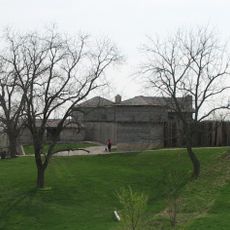
Wyman School is a three-story brick building with Classical Revival elements, showing symmetrical shapes and decorative columns rising from a limestone foundation. The property spans roughly 1.8 acres with the main structure, while its original power plant from 1913 was demolished in 2022.

The structure was built in 1912 and named after Anson Wyman, founder of Excelsior Springs. It functioned as a school until the mid-1990s, when it transitioned to different uses after education activities ended.

The building carries the name of Anson Wyman, founder of Excelsior Springs, connecting it to local history through its designation. Today it serves as a community theatre, showing how the space has adapted to meet the changing needs of residents over time.

The location sits in Excelsior Springs and is easy to spot from the street, with its Classical Revival exterior making it a noticeable landmark in town. Best visiting times are during theatre hours when the interior spaces are open to guests.

The building received listing on the National Register of Historic Places in July 2008, underscoring its importance for Missouri's architectural and educational history. This official recognition makes it one of the few school buildings from this period that holds this status in the region.

The community of curious travelers

AroundUs brings together thousands of curated places, local tips, and hidden gems, enriched daily by 60,000 contributors worldwide.

Start exploring
Location
GPS coordinates
39.34500,-94.22833
Latest update
December 14, 2025 18:20
Around this place
Fort Osage
United States of America

Fort Osage

17.8 km
Watkins Woolen Mill State Park and State Historic Site
United States of America

Watkins Woolen Mill State Park and State Historic Site

6.8 km
United States of America

Liberty Arsenal

22.4 km
James Brothers' House and Farm
United States of America

James Brothers' House and Farm

9.7 km
Odd Fellows Home District
United States of America

Odd Fellows Home District

20.1 km
Hall of Waters
United States of America

Hall of Waters

644 m
Sibley Railroad Bridge
United States of America

Sibley Railroad Bridge

18.8 km
Nebo Hill Archeological Site
United States of America

Nebo Hill Archeological Site

18.5 km
Clay County Savings Association Building
United States of America

Clay County Savings Association Building

19.7 km
Dougherty–Prospect Heights Historic District
United States of America

Dougherty–Prospect Heights Historic District

20.1 km
IOOF Liberty Lodge No. 49
United States of America

IOOF Liberty Lodge No. 49

19.7 km
Clinton House
United States of America

Clinton House

20 km
Jewell Hall
United States of America

Jewell Hall

19.2 km
South Liberty Courthouse Square Historic District
United States of America

South Liberty Courthouse Square Historic District

19.8 km
Claybrook House
United States of America

Claybrook House

10.4 km
First Methodist Church
United States of America

First Methodist Church

360 m
Ligon Apartments
United States of America

Ligon Apartments

575 m
Excelsior Springs Hall of Waters Commercial East Historic District
United States of America

Excelsior Springs Hall of Waters Commercial East Historic District

558 m
Ray County Courthouse
United States of America

Ray County Courthouse

22.9 km
Garrison School Historic District
United States of America

Garrison School Historic District

19.4 km
Watkins House
United States of America

Watkins House

22.8 km
Frank Hughes Memorial Library
United States of America

Frank Hughes Memorial Library

19.6 km
Miller Building
United States of America

Miller Building

19.8 km
Excelsior Springs Hall of Waters Commercial West Historic District
United States of America

Excelsior Springs Hall of Waters Commercial West Historic District

792 m
Missouri City Savings Bank Building and Meeting Hall
United States of America

Missouri City Savings Bank Building and Meeting Hall

13.2 km
Dougherty Auditorium
United States of America

Dougherty Auditorium

22.7 km
Ray County Poor Farm
United States of America

Ray County Poor Farm

22.1 km
Arthur-Leonard Historic District
United States of America

Arthur-Leonard Historic District

19.6 km
Show the full map
« Wyman School - Historic school building in Excelsior Springs, Missouri » is provided by Around Us (aroundus.com). Images and texts are derived from Wikimedia project under a Creative Commons license. You are allowed to copy, distribute, and modify copies of this page, under the conditions set by the license, as long as this note is clearly visible.

Discover hidden gems everywhere you go!

From secret cafés to breathtaking viewpoints, skip the crowded tourist spots and find places that match your style. Our app makes it easy with voice search, smart filtering, route optimization, and insider tips from travelers worldwide. Download now for the complete mobile experience.

Around Us App Screenshot

A unique approach to discovering new places

Le Figaro

All the places worth exploring

France Info

A tailor-made excursion in just a few clicks

20 Minutes

Around Us
Travel Guide & Maps
Download

Send to your phone

QR Code
1

Open the camera app on your mobile.

2

Point at the QR code with your camera. A notification will appear.

3

Tap the notification to open the link.