Enable Location

We need your location to show you interesting places around you

Discover nearby places

Find interesting locations and hidden gems around you

Precise directions

Get accurate directions and distances to places

Your location is never shared with other users. It's only used when you tap the location button.

James Brothers' House and Farm

Log in to your account

Start exploring — it's free

Trusted by 66,082 travelers worldwide

Continue with Google
Continue with Apple
or

We will send you a code to connect

By continuing, you accept our Terms and Conditions and our Privacy Policy

Check your inbox

We've sent a pincode in your inbox. Please enter the code below.

Discussion Reviews 1 Photos
3k Popularity

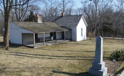
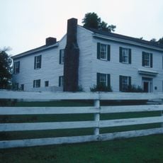
James Brothers' House and Farm, Historic farmhouse in Kearney, Missouri

The James Brothers' House and Farm is a farmhouse in Kearney, Missouri, made up of a log structure from the early 1800s and a later wood addition that gives the building a T-shape. The property includes several outbuildings set on open farmland that surrounds the main house.

The house was built in the early 1800s and served as the family home for several generations. It became widely known as the birthplace of Jesse and Frank James, two brothers who became notorious outlaws in the years after the Civil War.

The house is open as a museum today, with rooms furnished to show daily life on a Missouri farm in the 1800s. Objects connected to cooking, sleeping, and farm work are displayed in their original setting, giving a clear picture of how the family spent their days.

The property is a short drive east of Kearney and is best reached by car. Visitors walk the grounds to see the buildings, so comfortable footwear is helpful since the terrain can be uneven in places.

The mother of Jesse James, Zerelda Samuel, personally led tours of the farm and sold pebbles from her son's grave on the property to paying visitors. She is considered one of the first people in the country to turn a private home into a tourist attraction in this way.

The community of curious travelers

AroundUs brings together thousands of curated places, local tips, and hidden gems, enriched daily by 60,000 contributors worldwide.

Start exploring
Location
GPS coordinates
39.39333,-94.32167
Latest update
March 3, 2026 13:52
Around this place
Fort Osage
United States of America

Fort Osage

25.5 km
Kansas City Missouri Temple
United States of America

Kansas City Missouri Temple

24.7 km
Watkins Woolen Mill State Park and State Historic Site
United States of America

Watkins Woolen Mill State Park and State Historic Site

5.3 km
United States of America

Liberty Arsenal

22.8 km
Odd Fellows Home District
United States of America

Odd Fellows Home District

19.7 km
Hall of Waters
United States of America

Hall of Waters

10.3 km
United States of America

David L. and Sallie Ann Stoutimore House

21.7 km
Sibley Railroad Bridge
United States of America

Sibley Railroad Bridge

26.7 km
Nebo Hill Archeological Site
United States of America

Nebo Hill Archeological Site

20.6 km
Clay County Savings Association Building
United States of America

Clay County Savings Association Building

18.3 km
Woodneath
United States of America

Woodneath

20 km
Wyman School
United States of America

Wyman School

9.7 km
Dougherty–Prospect Heights Historic District
United States of America

Dougherty–Prospect Heights Historic District

18.5 km
IOOF Liberty Lodge No. 49
United States of America

IOOF Liberty Lodge No. 49

18.3 km
Clinton House
United States of America

Clinton House

19 km
Jewell Hall
United States of America

Jewell Hall

18.1 km
Claybrook House
United States of America

Claybrook House

1.4 km
South Liberty Courthouse Square Historic District
United States of America

South Liberty Courthouse Square Historic District

18.5 km
First Methodist Church
United States of America

First Methodist Church

10 km
Ligon Apartments
United States of America

Ligon Apartments

10.2 km
Excelsior Springs Hall of Waters Commercial East Historic District
United States of America

Excelsior Springs Hall of Waters Commercial East Historic District

10.2 km
Garrison School Historic District
United States of America

Garrison School Historic District

17.7 km
Frank Hughes Memorial Library
United States of America

Frank Hughes Memorial Library

18.2 km
Miller Building
United States of America

Miller Building

18.3 km
Excelsior Springs Hall of Waters Commercial West Historic District
United States of America

Excelsior Springs Hall of Waters Commercial West Historic District

9.2 km
Missouri City Savings Bank Building and Meeting Hall
United States of America

Missouri City Savings Bank Building and Meeting Hall

17.4 km
Arthur-Leonard Historic District
United States of America

Arthur-Leonard Historic District

18.4 km
Liberty Bend Bridge
United States of America

Liberty Bend Bridge

25.9 km
Show the full map
Reviews
Share your experience

No review yet

Discussions
Start a discussion...

No discussion yet

« James Brothers' House and Farm - Historic farmhouse in Kearney, Missouri » is provided by Around Us (aroundus.com). Images and texts are derived from Wikimedia project under a Creative Commons license. You are allowed to copy, distribute, and modify copies of this page, under the conditions set by the license, as long as this note is clearly visible.

Discover hidden gems everywhere you go!

From secret cafés to breathtaking viewpoints, skip the crowded tourist spots and find places that match your style. Our app makes it easy with voice search, smart filtering, route optimization, and insider tips from travelers worldwide. Download now for the complete mobile experience.

Around Us App Screenshot

A unique approach to discovering new places

Le Figaro

All the places worth exploring

France Info

A tailor-made excursion in just a few clicks

20 Minutes

Around Us
Travel Guide & Maps
Download

Send to your phone

QR Code
1

Open the camera app on your mobile.

2

Point at the QR code with your camera. A notification will appear.

3

Tap the notification to open the link.