Enable Location

We need your location to show you interesting places around you

Discover nearby places

Find interesting locations and hidden gems around you

Precise directions

Get accurate directions and distances to places

Your location is never shared with other users. It's only used when you tap the location button.

Braley Covered Bridge

Log in to your account

Start exploring — it's free

Trusted by 62,440 travelers worldwide

Continue with Google
Continue with Apple
or

We will send you a code to connect

By continuing, you accept our Terms and Conditions and our Privacy Policy

Check your inbox

We've sent a pincode in your inbox. Please enter the code below.

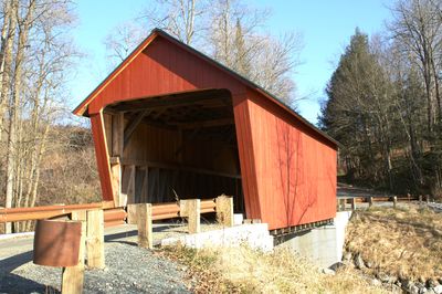
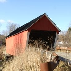
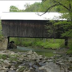
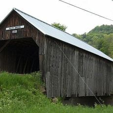
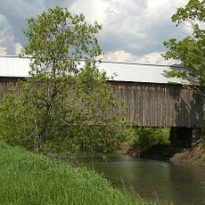
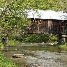
Braley Covered Bridge, Historic covered bridge in Vermont

The Braley Covered Bridge is a wooden crossing over the Second Branch of the White River in Randolph, Vermont. It measures about 40 feet (12 meters) long and just over 14 feet (4 meters) wide, resting on dry-laid stone supports with vertical wooden siding and a metal roof that covers the entire structure.

The structure was completed in 1904 and received its protective roof and walls about five years later. In 1977, steel beams were added underneath the wooden deck to reinforce the structure for modern vehicles.

The Braley Covered Bridge represents local craftsmanship in how it was built and maintained by the community. The wooden structure and its red paint show practical choices that early builders made to help the bridge survive in the Vermont countryside.

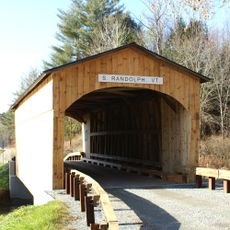
The crossing is accessible from a quiet rural road and can be used on foot or by car, though the single-lane width requires slow passage. The surrounding area offers open fields and trees with no facilities or signage nearby, making it a peaceful stop for visitors.

This bridge is one of only two in Vermont where the main trusses reach only halfway up the side walls. This unusual design suggests the structure was originally built without a roof and walls, which were added later to protect the wood.

The community of curious travelers

AroundUs brings together thousands of curated places, local tips, and hidden gems, enriched daily by 60,000 contributors worldwide.

Start exploring
Location
GPS coordinates
43.92833,-72.55722
Latest update
February 9, 2026 07:44
Around this place
Randolph Center Historic District
United States of America

Randolph Center Historic District

4.6 km
Mill Covered Bridge
United States of America

Mill Covered Bridge

6.7 km
Flint Covered Bridge
United States of America

Flint Covered Bridge

8.2 km
Gifford Covered Bridge
United States of America

Gifford Covered Bridge

1.4 km
Old Christ Church
United States of America

Old Christ Church

9.4 km
Joseph Fessenden House
United States of America

Joseph Fessenden House

12.6 km
Kingsbury Covered Bridge
United States of America

Kingsbury Covered Bridge

5.6 km
Moxley Covered Bridge
United States of America

Moxley Covered Bridge

8.2 km
Chandler Music Hall
United States of America

Chandler Music Hall

8.7 km
Cilley Covered Bridge
United States of America

Cilley Covered Bridge

6.6 km
Howe Covered Bridge
United States of America

Howe Covered Bridge

8.5 km
Mari-Castle
United States of America

Mari-Castle

9 km
Kimball Public Library
United States of America

Kimball Public Library

8.7 km
Marvin Newton House
United States of America

Marvin Newton House

11.3 km
Fox Stand
United States of America

Fox Stand

11.7 km
Foundry Bridge
United States of America

Foundry Bridge

6.6 km
St. Paul's Episcopal Church
United States of America

St. Paul's Episcopal Church

12.6 km
South Tunbridge Methodist Episcopal Church
United States of America

South Tunbridge Methodist Episcopal Church

9.1 km
South Royalton Historic District
United States of America

South Royalton Historic District

12.3 km
Larkin Covered Bridge
United States of America

Larkin Covered Bridge

7.4 km
Gilead Brook Bridge
United States of America

Gilead Brook Bridge

9.5 km
Chelsea Street Bridge
United States of America

Chelsea Street Bridge

12.1 km
Hayward and Kibby Mill
United States of America

Hayward and Kibby Mill

6.7 km
Bethel Village Historic District
United States of America

Bethel Village Historic District

12.5 km
Chelsea Village Historic District
United States of America

Chelsea Village Historic District

11.1 km
McKenstry Manor
United States of America

McKenstry Manor

9.9 km
Depot Square Historic District
United States of America

Depot Square Historic District

8.6 km
Tunbridge Village Historic District
United States of America

Tunbridge Village Historic District

6.8 km
Show the full map
« Braley Covered Bridge - Historic covered bridge in Vermont » is provided by Around Us (aroundus.com). Images and texts are derived from Wikimedia project under a Creative Commons license. You are allowed to copy, distribute, and modify copies of this page, under the conditions set by the license, as long as this note is clearly visible.

Discover hidden gems everywhere you go!

From secret cafés to breathtaking viewpoints, skip the crowded tourist spots and find places that match your style. Our app makes it easy with voice search, smart filtering, route optimization, and insider tips from travelers worldwide. Download now for the complete mobile experience.

Around Us App Screenshot

A unique approach to discovering new places

Le Figaro

All the places worth exploring

France Info

A tailor-made excursion in just a few clicks

20 Minutes

Around Us
Travel Guide & Maps
Download

Send to your phone

QR Code
1

Open the camera app on your mobile.

2

Point at the QR code with your camera. A notification will appear.

3

Tap the notification to open the link.