Enable Location

We need your location to show you interesting places around you

Discover nearby places

Find interesting locations and hidden gems around you

Precise directions

Get accurate directions and distances to places

Your location is never shared with other users. It's only used when you tap the location button.

Bridge Street Bridge

Log in to your account

Start exploring — it's free

Trusted by 61,575 travelers worldwide

Continue with Google
Continue with Apple
or

We will send you a code to connect

By continuing, you accept our Terms and Conditions and our Privacy Policy

Check your inbox

We've sent a pincode in your inbox. Please enter the code below.

Bridge Street Bridge

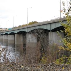
Bridge Street Bridge, Road bridge in Windsor Locks, Connecticut, United States.

Description

Bridge Street Bridge is a road bridge that spans the Connecticut River between Windsor Locks and East Windsor. The modern steel structure carries Route 140 across the river and serves as a key connection for local and commercial traffic between the two communities.

History

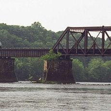
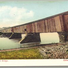
A suspension bridge first served this crossing in 1886, followed by a steel truss structure in 1921. The current bridge, built in 1992, represents a modern replacement that continues the site's long history of river connections.

Culture

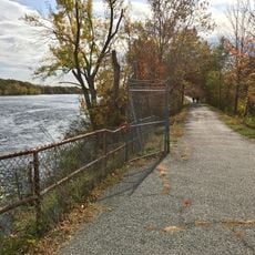
The bridge links two communities across the river and has become woven into the daily routes of people who travel between Windsor Locks and East Windsor. It shapes how residents experience their connection to neighboring towns and serves as a practical meeting point of local life.

Practical

The bridge is accessible during normal travel hours as part of Route 140 operations, though pedestrians should know this is primarily a roadway. Stopping or parking directly on the bridge is not permitted.

Did you know?

Before the first bridge was built in 1886, a ferry boat secured to a mid-river pier provided the only crossing at this site. This early transportation method reveals just how critical a dependable river passage has always been for the area.

Location
GPS coordinates
41.92920,-72.62420
Latest update
December 14, 2025 14:43

AroundUs brings together thousands of curated places, local tips, and hidden gems, enriched daily by 60,000 contributors worldwide. Discover all places nearby (Connecticut).

Around this place
Connecticut Trolley Museum
United States of America

Connecticut Trolley Museum

2.5 km
Dexter Coffin Bridge
United States of America

Dexter Coffin Bridge

1.4 km
Windsor Locks Canal State Park Trail
United States of America

Windsor Locks Canal State Park Trail

6.6 km
Oliver Ellsworth Homestead
United States of America

Oliver Ellsworth Homestead

5.7 km
Enfield–Suffield Veterans Bridge
United States of America

Enfield–Suffield Veterans Bridge

6.9 km
United States of America

Northwest Park

7.1 km
Warehouse Point railroad bridge
United States of America

Warehouse Point railroad bridge

1.8 km
Enfield–Suffield Covered Bridge
United States of America

Enfield–Suffield Covered Bridge

5.3 km
Alexander King House
United States of America

Alexander King House

5.7 km
Hatheway House
United States of America

Hatheway House

6.1 km
Enfield Town Meetinghouse
United States of America

Enfield Town Meetinghouse

5.9 km
Suffield Historic District
United States of America

Suffield Historic District

6.2 km
Memorial Hall
United States of America

Memorial Hall

869 m
Bissell Tavern-Bissell's Stage House
United States of America

Bissell Tavern-Bissell's Stage House

4.7 km
Horace H. Ellsworth House
United States of America

Horace H. Ellsworth House

7.3 km
Taylor Chapman House
United States of America

Taylor Chapman House

7 km
Bridge No. 455
United States of America

Bridge No. 455

3.3 km
Noden-Reed Museum
United States of America

Noden-Reed Museum

1.4 km
Enfield Historic District
United States of America

Enfield Historic District

5.8 km
Melrose Road Bridge
United States of America

Melrose Road Bridge

6.4 km
First Church Parsonage
United States of America

First Church Parsonage

6.9 km
Eli Phelps House
United States of America

Eli Phelps House

6.1 km
Benomi Case House
United States of America

Benomi Case House

5.8 km
Sophia Sweetland House
United States of America

Sophia Sweetland House

6.9 km
House at 736 Palisado Avenue
United States of America

House at 736 Palisado Avenue

5.8 km
Henry Magill House
United States of America

Henry Magill House

7.1 km
Patrick Murphy House
United States of America

Patrick Murphy House

7.2 km
New England Air Museum
United States of America

New England Air Museum

5.9 km
Show the full map
« Bridge Street Bridge - Road bridge in Windsor Locks, Connecticut, United States » is provided by Around Us (aroundus.com). Images and texts are derived from Wikimedia project under a Creative Commons license. You are allowed to copy, distribute, and modify copies of this page, under the conditions set by the license, as long as this note is clearly visible.

Discover hidden gems everywhere you go!

From secret cafés to breathtaking viewpoints, skip the crowded tourist spots and find places that match your style. Our app makes it easy with voice search, smart filtering, route optimization, and insider tips from travelers worldwide. Download now for the complete mobile experience.

Around Us App Screenshot

A unique approach to discovering new places

Le Figaro

All the places worth exploring

France Info

A tailor-made excursion in just a few clicks

20 Minutes

Around Us
Travel Guide & Maps
Download

Send to your phone

QR Code
1

Open the camera app on your mobile.

2

Point at the QR code with your camera. A notification will appear.

3

Tap the notification to open the link.