Enfield–Suffield Covered Bridge

Log in to your account

AroundUs is a community-driven map of interesting places, built by curious explorers like you. It grows with every review, story, and photo you share.
Connect to save your favorite spots, contribute locations, and create personalized routes.
Continue with Google
Continue with Apple
Continue with X
Continue with Facebook
Continue with email
By continuing, you accept our Terms and Conditions and our Privacy Policy
Create an account

Enfield–Suffield Covered Bridge

Add to collection
Map
Suggest a change
Share

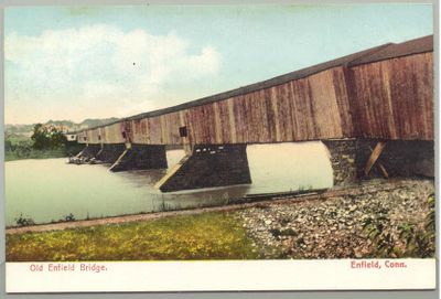
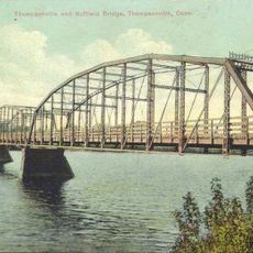
Enfield–Suffield Covered Bridge, Wooden covered bridge in Hartford County, United States.

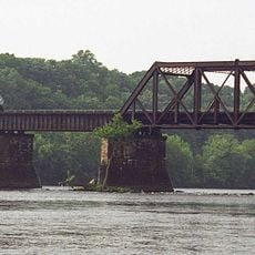
The Enfield-Suffield Covered Bridge was a wooden structure that crossed the Connecticut River, joining two towns on opposite banks. The bridge featured timber construction with support piers that formed small islands in the water, typical of river bridges from that era.

The bridge was built in 1821 to connect two towns across the river and served this purpose until a major flood destroyed it in 1900. After this event, the structure was not rebuilt, leaving only its support piers visible in the water as a reminder of what once stood there.

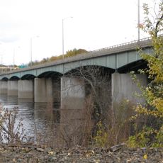
The bridge served as a vital connection between two communities, shaping daily life and trade routes for generations. Today, the remains visible in the river remind visitors of how important this crossing was to local people.

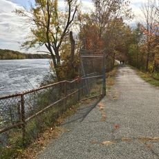
The site where the bridge once stood can be accessed from the Connecticut River banks, where the old piers are still visible in the water. Visitors can walk along the riverbank in the area to view these historical remains from different angles and perspectives.

During the 1900 flood, a railroad agent survived by riding a section of the collapsed bridge downstream until workers rescued him at another location. This unlikely survival story became a memorable part of the disaster's local memory.

Location: Hartford County

Official opening: 1821

Made from material: wood

GPS coordinates: 41.97510,-72.60620

Latest update: December 14, 2025 17:04

Photos
Around this place
Six Flags New England
United States of America

Six Flags New England

7 km
Bizarro
United States of America

Bizarro

7.1 km
Wicked Cyclone
United States of America

Wicked Cyclone

7.3 km
Batman – The Dark Knight
United States of America

Batman – The Dark Knight

6.7 km
Thunderbolt
United States of America

Thunderbolt

7.1 km
Connecticut Trolley Museum
United States of America

Connecticut Trolley Museum

5 km
Dexter Coffin Bridge
United States of America

Dexter Coffin Bridge

6.6 km
Windsor Locks Canal State Park Trail
United States of America

Windsor Locks Canal State Park Trail

1.3 km
Bridge Street Bridge
United States of America

Bridge Street Bridge

5.3 km
Enfield–Suffield Veterans Bridge
United States of America

Enfield–Suffield Veterans Bridge

1.6 km
Warehouse Point railroad bridge
United States of America

Warehouse Point railroad bridge

3.6 km
Hazardville Historic District
United States of America

Hazardville Historic District

6.2 km
Suffield and Thompsonville Bridge
United States of America

Suffield and Thompsonville Bridge

2.7 km
Alexander King House
United States of America

Alexander King House

3.9 km
Hatheway House
United States of America

Hatheway House

3.9 km
Enfield Town Meetinghouse
United States of America

Enfield Town Meetinghouse

1.2 km
Suffield Historic District
United States of America

Suffield Historic District

3.8 km
Bigelow-Hartford Carpet Mills Historic District
United States of America

Bigelow-Hartford Carpet Mills Historic District

2.8 km
Memorial Hall
United States of America

Memorial Hall

6.2 km
Bridge No. 455
United States of America

Bridge No. 455

2.6 km
Enfield Historic District
United States of America

Enfield Historic District

1 km
Noden-Reed Museum
United States of America

Noden-Reed Museum

5.5 km
Melrose Road Bridge
United States of America

Melrose Road Bridge

6.4 km
King's Field House
United States of America

King's Field House

4.5 km
John Fuller House
United States of America

John Fuller House

6.3 km
Cyclone
United States of America

Cyclone

7.3 km
Pandemonium
United States of America

Pandemonium

7.3 km
Catwoman's Whip
United States of America

Catwoman's Whip

6.9 km
Show the full map
Reviews

Visited this place? Tap the stars to rate it and share your experience / photos with the community! Try now! You can cancel it anytime.

« Enfield–Suffield Covered Bridge - Wooden covered bridge in Hartford County, United States » is provided by Around Us (aroundus.com). Images and texts are derived from Wikimedia project under a Creative Commons license. You are allowed to copy, distribute, and modify copies of this page, under the conditions set by the license, as long as this note is clearly visible.

Discover hidden gems everywhere you go!

From secret cafés to breathtaking viewpoints, skip the crowded tourist spots and find places that match your style. Our app makes it easy with voice search, smart filtering, route optimization, and insider tips from travelers worldwide. Download now for the complete mobile experience.

Around Us App Screenshot

A unique approach to discovering new places

Le Figaro

All the places worth exploring

France Info

A tailor-made excursion in just a few clicks

20 Minutes