Enable Location

We need your location to show you interesting places around you

Discover nearby places

Find interesting locations and hidden gems around you

Precise directions

Get accurate directions and distances to places

Your location is never shared with other users. It's only used when you tap the location button.

Suffield and Thompsonville Bridge

Log in to your account

Start exploring — it's free

Trusted by 61,575 travelers worldwide

Continue with Google
Continue with Apple
or

We will send you a code to connect

By continuing, you accept our Terms and Conditions and our Privacy Policy

Check your inbox

We've sent a pincode in your inbox. Please enter the code below.

Suffield and Thompsonville Bridge

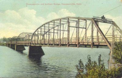
Suffield and Thompsonville Bridge, Truss bridge in Suffield, United States.

Description

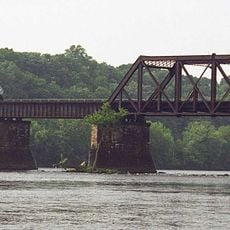
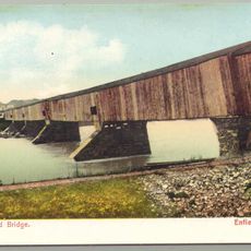
The Suffield and Thompsonville Bridge was an iron truss structure that spanned the Connecticut River with five metal arches supported by four stone piers sunk into the riverbed. The entire crossing measured approximately 1,060 feet between its anchoring points on both banks.

History

The Berlin Iron Bridge Company constructed this crossing in January 1893 as part of a broader wave of industrial bridge building across the Northeast. The iron superstructure remained in service for more than 75 years before its removal in 1971, though the stone foundation piers persist in the river.

Culture

The structure connected two communities separated by the Connecticut River, serving as a vital link that shaped local trade routes and travel patterns. Both towns depended on this crossing for their economic relationship and daily interaction.

Practical

The four stone piers remain visible from various viewpoints along the riverbank and from the towns on either side. Visitors can best observe these remnants during seasons when vegetation is minimal, making the stonework easier to spot from roads and pathways near the river.

Did you know?

Nathan Hemenway was the first person hired to collect tolls at this crossing, charging pedestrians three cents and wagon teams twelve cents for passage. His role illustrates how the bridge operators depended on these small but frequent payments to maintain the structure.

Location
Official opening
February 20, 1893
GPS coordinates
41.99920,-72.60710
Latest update
December 14, 2025 18:00

AroundUs brings together thousands of curated places, local tips, and hidden gems, enriched daily by 60,000 contributors worldwide. Discover all places nearby (Connecticut).

Around this place
Six Flags New England
United States of America

Six Flags New England

4.3 km
Bizarro
United States of America

Bizarro

4.4 km
Wicked Cyclone
United States of America

Wicked Cyclone

4.6 km
Batman – The Dark Knight
United States of America

Batman – The Dark Knight

4 km
Thunderbolt
United States of America

Thunderbolt

4.4 km
Gotham City Gauntlet: Escape from Arkham Asylum
United States of America

Gotham City Gauntlet: Escape from Arkham Asylum

4.7 km
Connecticut Trolley Museum
United States of America

Connecticut Trolley Museum

7.6 km
Windsor Locks Canal State Park Trail
United States of America

Windsor Locks Canal State Park Trail

1.4 km
Enfield–Suffield Veterans Bridge
United States of America

Enfield–Suffield Veterans Bridge

1.1 km
Warehouse Point railroad bridge
United States of America

Warehouse Point railroad bridge

6.2 km
Enfield–Suffield Covered Bridge
United States of America

Enfield–Suffield Covered Bridge

2.7 km
Hazardville Historic District
United States of America

Hazardville Historic District

6.8 km
Alexander King House
United States of America

Alexander King House

4.7 km
Hatheway House
United States of America

Hatheway House

4.3 km
Enfield Town Meetinghouse
United States of America

Enfield Town Meetinghouse

2.7 km
Suffield Historic District
United States of America

Suffield Historic District

4.2 km
Agawam Center Historic District
United States of America

Agawam Center Historic District

7.6 km
Bigelow-Hartford Carpet Mills Historic District
United States of America

Bigelow-Hartford Carpet Mills Historic District

453 m
Hastings Hill Historic District
United States of America

Hastings Hill Historic District

6.1 km
Bridge No. 455
United States of America

Bridge No. 455

4.9 km
Enfield Historic District
United States of America

Enfield Historic District

2.8 km
King's Field House
United States of America

King's Field House

3.2 km
Purchase-Ferre House
United States of America

Purchase-Ferre House

5.6 km
John Fuller House
United States of America

John Fuller House

4.6 km
Cyclone
United States of America

Cyclone

4.6 km
Pandemonium
United States of America

Pandemonium

4.6 km
Catwoman's Whip
United States of America

Catwoman's Whip

4.2 km
Longmeadow Historic District
United States of America

Longmeadow Historic District

5.9 km
Show the full map
« Suffield and Thompsonville Bridge - Truss bridge in Suffield, United States » is provided by Around Us (aroundus.com). Images and texts are derived from Wikimedia project under a Creative Commons license. You are allowed to copy, distribute, and modify copies of this page, under the conditions set by the license, as long as this note is clearly visible.

Discover hidden gems everywhere you go!

From secret cafés to breathtaking viewpoints, skip the crowded tourist spots and find places that match your style. Our app makes it easy with voice search, smart filtering, route optimization, and insider tips from travelers worldwide. Download now for the complete mobile experience.

Around Us App Screenshot

A unique approach to discovering new places

Le Figaro

All the places worth exploring

France Info

A tailor-made excursion in just a few clicks

20 Minutes

Around Us
Travel Guide & Maps
Download

Send to your phone

QR Code
1

Open the camera app on your mobile.

2

Point at the QR code with your camera. A notification will appear.

3

Tap the notification to open the link.