Enable Location

We need your location to show you interesting places around you

Discover nearby places

Find interesting locations and hidden gems around you

Precise directions

Get accurate directions and distances to places

Your location is never shared with other users. It's only used when you tap the location button.

Congregation Adath Jeshurun

Log in to your account

Start exploring — it's free

Trusted by 61,464 travelers worldwide

Continue with Google
Continue with Apple
or

We will send you a code to connect

By continuing, you accept our Terms and Conditions and our Privacy Policy

Check your inbox

We've sent a pincode in your inbox. Please enter the code below.

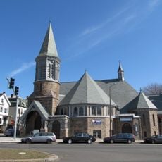
Congregation Adath Jeshurun, Former synagogue in Roxbury, Boston, Massachusetts.

Description

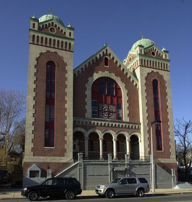
Congregation Adath Jeshurun is a Romanesque Revival building on Blue Hill Avenue distinguished by two prominent domes that anchor its streetscape. The structure displays architectural details typical of early 1900s religious buildings, including ornamental work on the facade and roof.

History

The Jewish community established the congregation in 1894 and commissioned architect Frederick Norcross to design a synagogue building, completed in 1906. In 1978, a Haitian Baptist church took over the building and has used it for religious gatherings since then.

Culture

The building reflects Boston's religious diversity, having served first as a synagogue for the Jewish community before becoming a gathering place for a Haitian Christian congregation. This shift in use mirrors the changing makeup of residents in the Roxbury neighborhood over the decades.

Practical

The building is clearly visible and accessible from Blue Hill Avenue, making it straightforward to view its exterior architecture. Visitors should check ahead regarding access times, as the building remains in active use for services and community gatherings.

Did you know?

The building earned recognition on the National Register of Historic Places in 1999, documenting its role in Boston's religious architectural heritage. This listing acknowledges how the structure illustrates the evolution of sacred buildings in the city.

Location
GPS coordinates
42.31139,-71.08153
Latest update
December 14, 2025 17:42

AroundUs brings together thousands of curated places, local tips, and hidden gems, enriched daily by 60,000 contributors worldwide. Discover all places nearby (Massachusetts).

Around this place
Franklin Park Zoo
United States of America

Franklin Park Zoo

929 m
Franklin Park
United States of America

Franklin Park

1.5 km
United States of America

Strand Theatre

1.4 km
Malcolm X—Ella Little-Collins House
United States of America

Malcolm X—Ella Little-Collins House

1.2 km
Shirley-Eustis House
United States of America

Shirley-Eustis House

1.5 km
Mosque No. 11
United States of America

Mosque No. 11

116 m
St. Joseph Catholic Church
United States of America

St. Joseph Catholic Church

1.5 km
Abbotsford
United States of America

Abbotsford

1.1 km
Roxbury Presbyterian Church
United States of America

Roxbury Presbyterian Church

897 m
Eliot Congregational Church
United States of America

Eliot Congregational Church

897 m
Upham's Corner Market
United States of America

Upham's Corner Market

1.5 km
St. Mark's Episcopal Church
United States of America

St. Mark's Episcopal Church

807 m
Home for Aged Couples
United States of America

Home for Aged Couples

1.2 km
Pilgrim Congregational Church
United States of America

Pilgrim Congregational Church

1.3 km
Moreland Street Historic District
United States of America

Moreland Street Historic District

1.4 km
Harriswood Crescent
United States of America

Harriswood Crescent

997 m
Intervale Street-Columbia Road Historic District
United States of America

Intervale Street-Columbia Road Historic District

525 m
Lawrence Avenue Historic District
United States of America

Lawrence Avenue Historic District

382 m
Intervale Street-Blue Hill Avenue Historic District
United States of America

Intervale Street-Blue Hill Avenue Historic District

130 m
Columbia Road–Devon Street Historic District
United States of America

Columbia Road–Devon Street Historic District

651 m
Elm Hill Park Historic District
United States of America

Elm Hill Park Historic District

174 m
Crawford Street Historic District
United States of America

Crawford Street Historic District

287 m
Columbia Road–Bellevue Street Historic District
United States of America

Columbia Road–Bellevue Street Historic District

1.1 km
Columbia Road-Strathcona Road Historic District
United States of America

Columbia Road-Strathcona Road Historic District

642 m
Nathan Warnick Apartments
United States of America

Nathan Warnick Apartments

1.4 km
Doris Bunte Apartments
United States of America

Doris Bunte Apartments

1.4 km
Nazing Court Apartments
United States of America

Nazing Court Apartments

1.3 km
Egleston Square Branch Library
United States of America

Egleston Square Branch Library

1.2 km
Show the full map
« Congregation Adath Jeshurun - Former synagogue in Roxbury, Boston, Massachusetts » is provided by Around Us (aroundus.com). Images and texts are derived from Wikimedia project under a Creative Commons license. You are allowed to copy, distribute, and modify copies of this page, under the conditions set by the license, as long as this note is clearly visible.

Discover hidden gems everywhere you go!

From secret cafés to breathtaking viewpoints, skip the crowded tourist spots and find places that match your style. Our app makes it easy with voice search, smart filtering, route optimization, and insider tips from travelers worldwide. Download now for the complete mobile experience.

Around Us App Screenshot

A unique approach to discovering new places

Le Figaro

All the places worth exploring

France Info

A tailor-made excursion in just a few clicks

20 Minutes

Around Us
Travel Guide & Maps
Download

Send to your phone

QR Code
1

Open the camera app on your mobile.

2

Point at the QR code with your camera. A notification will appear.

3

Tap the notification to open the link.