Enable Location

We need your location to show you interesting places around you

Discover nearby places

Find interesting locations and hidden gems around you

Precise directions

Get accurate directions and distances to places

Your location is never shared with other users. It's only used when you tap the location button.

Crotched Mountain

Log in to your account

Start exploring — it's free

Trusted by 67,207 travelers worldwide

Continue with Google
Continue with Apple
or

We will send you a code to connect

By continuing, you accept our Terms and Conditions and our Privacy Policy

Check your inbox

We've sent a pincode in your inbox. Please enter the code below.

Crotched Mountain
Discussion Reviews 1 Photos
8.2k Popularity

Crotched Mountain, Mountain summit in Francestown, United States

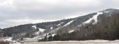
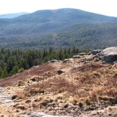
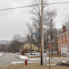
Crotched Mountain is a summit in western New Hampshire, sitting across the towns of Francestown, Bennington, and Greenfield. The mountain has a developed ski area with several trails and chairlifts on its slopes, making it one of the more accessible peaks in the region for winter sports.

In 1980, the mountain was home to what is considered the world's first wind farm, an early attempt to generate electricity from wind on a commercial scale. The installation was later taken down, but it placed Crotched Mountain in the history of renewable energy well before the concept became widespread.

The mountain's name comes from early settlers who saw the split shape of the summit and compared it to a forked tree branch. Locals still use the name naturally today, and it gives the place a character that sets it apart from more generic mountain names in the region.

The mountain is open year-round, though the ski area runs only in winter and trail conditions change with the seasons. Visiting in shoulder seasons means fewer crowds and a different experience on the slopes and surrounding paths.

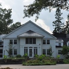
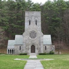
A rehabilitation center sits on the southern ridge of the mountain in Greenfield, offering specialized medical care in a setting that most visitors do not expect to find here. It shows that the mountain serves as more than a place for winter sports and outdoor recreation.

The community of curious travelers

AroundUs brings together thousands of curated places, local tips, and hidden gems, enriched daily by 60,000 contributors worldwide.

Start exploring
Location
GPS coordinates
42.99829,-71.87391
Latest update
March 3, 2026 10:11
Around this place
MacDowell
United States of America

MacDowell

13.7 km
North Pack Monadnock
United States of America

North Pack Monadnock

12.5 km
Greenfield State Park
United States of America

Greenfield State Park

5 km
Wapack National Wildlife Refuge
United States of America

Wapack National Wildlife Refuge

12.8 km
All Saints Church
United States of America

All Saints Church

14.4 km
Hillsborough Railroad Bridge
United States of America

Hillsborough Railroad Bridge

12.9 km
Levi Woodbury Homestead
United States of America

Levi Woodbury Homestead

5.1 km
Union Chapel
United States of America

Union Chapel

13.9 km
Hancock Village Historic District
United States of America

Hancock Village Historic District

9.3 km
Greenfield Meeting House
United States of America

Greenfield Meeting House

5.3 km
Moses Eaton, Jr., House
United States of America

Moses Eaton, Jr., House

13.9 km
Francestown Meetinghouse
United States of America

Francestown Meetinghouse

5.1 km
Contoocook Mills Industrial District
United States of America

Contoocook Mills Industrial District

12.9 km
Glenchrest
United States of America

Glenchrest

13.7 km
Gov. John Butler Smith House
United States of America

Gov. John Butler Smith House

13.3 km
Old County Road South Historic District
United States of America

Old County Road South Historic District

6.1 km
Deacon Abijah Richardson House
United States of America

Deacon Abijah Richardson House

14.2 km
Caleb Whittaker Place
United States of America

Caleb Whittaker Place

12 km
Abijah Richardson, Sr. Homestead
United States of America

Abijah Richardson, Sr. Homestead

14.1 km
Francestown Town Hall and Academy and Town Common Historic District
United States of America

Francestown Town Hall and Academy and Town Common Historic District

5.2 km
John Richardson Homestead
United States of America

John Richardson Homestead

13.8 km
Gilchrest
United States of America

Gilchrest

14.2 km
Flint Estate
United States of America

Flint Estate

12.8 km
Hancock-Greenfield Bridge
United States of America

Hancock-Greenfield Bridge

6.8 km
Lyndeborough Center Historic District
United States of America

Lyndeborough Center Historic District

13.5 km
Alcott Trestle
United States of America

Alcott Trestle

9.8 km
Sawyer Bridge
United States of America

Sawyer Bridge

13.1 km
Weare Reservoir
United States of America

Weare Reservoir

13.3 km
Show the full map
Reviews
Share your experience

No review yet

Discussions
Start a discussion...

No discussion yet

« Crotched Mountain - Mountain summit in Francestown, United States » is provided by Around Us (aroundus.com). Images and texts are derived from Wikimedia project under a Creative Commons license. You are allowed to copy, distribute, and modify copies of this page, under the conditions set by the license, as long as this note is clearly visible.

Discover hidden gems everywhere you go!

From secret cafés to breathtaking viewpoints, skip the crowded tourist spots and find places that match your style. Our app makes it easy with voice search, smart filtering, route optimization, and insider tips from travelers worldwide. Download now for the complete mobile experience.

Around Us App Screenshot

A unique approach to discovering new places

Le Figaro

All the places worth exploring

France Info

A tailor-made excursion in just a few clicks

20 Minutes

Around Us
Travel Guide & Maps
Download

Send to your phone

QR Code
1

Open the camera app on your mobile.

2

Point at the QR code with your camera. A notification will appear.

3

Tap the notification to open the link.