Enable Location

We need your location to show you interesting places around you

Discover nearby places

Find interesting locations and hidden gems around you

Precise directions

Get accurate directions and distances to places

Your location is never shared with other users. It's only used when you tap the location button.

Farmers State Bank

Log in to your account

Start exploring — it's free

Trusted by 62,526 travelers worldwide

Continue with Google
Continue with Apple
or

We will send you a code to connect

By continuing, you accept our Terms and Conditions and our Privacy Policy

Check your inbox

We've sent a pincode in your inbox. Please enter the code below.

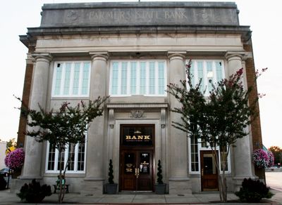
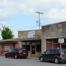
Farmers State Bank, Historic bank building in Leslie, Arkansas.

Farmers State Bank is a single-story brick building in Leslie with three bays topped by rounded arches framed in limestone trim. The structure sits at the corner of Main and Walnut Streets in the town's commercial district.

Built in 1910, the structure originally housed a working bank that operated until the economic collapse of the 1930s forced it to close. Following its shutdown, the building transitioned to serve as Leslie's post office.

The structure stands as a representation of early 20th-century financial institutions in rural Arkansas communities, demonstrating the period's architectural preferences and economic development.

The building sits in the heart of Leslie's commercial area and is easy to reach on foot. Visitors can view the original brick exterior and see the architectural details from the street.

The building earned recognition from the National Register in 1993 as part of a multiple-property documentation of historic structures across Searcy County. This designation recognized the Romanesque Revival style within the broader context of regional architecture.

The community of curious travelers

AroundUs brings together thousands of curated places, local tips, and hidden gems, enriched daily by 60,000 contributors worldwide.

Start exploring
Location
Architects
Charles L. Thompson and associates
GPS coordinates
35.09194,-92.44111
Latest update
December 14, 2025 18:45
Around this place
Century Flyer
United States of America

Century Flyer

1.6 km
First United Methodist Church
United States of America

First United Methodist Church

406 m
Galloway Hall
United States of America

Galloway Hall

1.1 km
Faulkner County Museum
United States of America

Faulkner County Museum

384 m
Martin Hall
United States of America

Martin Hall

835 m
Ellis Hall
United States of America

Ellis Hall

688 m
Frauenthal House
United States of America

Frauenthal House

1.6 km
Faulkner County Courthouse
United States of America

Faulkner County Courthouse

372 m
Hall–Hogan Grocery Store
United States of America

Hall–Hogan Grocery Store

1 km
Conway Confederate Monument
United States of America

Conway Confederate Monument

414 m
Earl and Mildred Ward House
United States of America

Earl and Mildred Ward House

832 m
Young Memorial
United States of America

Young Memorial

929 m
J.E. Little House
United States of America

J.E. Little House

1.6 km
Harton House
United States of America

Harton House

847 m
Administration Building, University of Central Arkansas
United States of America

Administration Building, University of Central Arkansas

2 km
Robinson Historic District
United States of America

Robinson Historic District

703 m
Reuben W. Robins House
United States of America

Reuben W. Robins House

528 m
Brown House
United States of America

Brown House

459 m
D.O. Harton House
United States of America

D.O. Harton House

885 m
Lasley's College Apartments
United States of America

Lasley's College Apartments

1.4 km
Hendrix College Addition Neighborhood Historic District
United States of America

Hendrix College Addition Neighborhood Historic District

1.4 km
Frank E. Robins House
United States of America

Frank E. Robins House

681 m
S.G. Smith House
United States of America

S.G. Smith House

863 m
Conway Commercial Historic District
United States of America

Conway Commercial Historic District

137 m
Frank U. Halter House
United States of America

Frank U. Halter House

867 m
Greeson-Cone House
United States of America

Greeson-Cone House

342 m
O.L. Dunaway House
United States of America

O.L. Dunaway House

386 m
Michael M. Hiegel House
United States of America

Michael M. Hiegel House

896 m
Show the full map
« Farmers State Bank - Historic bank building in Leslie, Arkansas » is provided by Around Us (aroundus.com). Images and texts are derived from Wikimedia project under a Creative Commons license. You are allowed to copy, distribute, and modify copies of this page, under the conditions set by the license, as long as this note is clearly visible.

Discover hidden gems everywhere you go!

From secret cafés to breathtaking viewpoints, skip the crowded tourist spots and find places that match your style. Our app makes it easy with voice search, smart filtering, route optimization, and insider tips from travelers worldwide. Download now for the complete mobile experience.

Around Us App Screenshot

A unique approach to discovering new places

Le Figaro

All the places worth exploring

France Info

A tailor-made excursion in just a few clicks

20 Minutes

Around Us
Travel Guide & Maps
Download

Send to your phone

QR Code
1

Open the camera app on your mobile.

2

Point at the QR code with your camera. A notification will appear.

3

Tap the notification to open the link.