Enable Location

We need your location to show you interesting places around you

Discover nearby places

Find interesting locations and hidden gems around you

Precise directions

Get accurate directions and distances to places

Your location is never shared with other users. It's only used when you tap the location button.

Fiddler's Reach Fog Signal

Log in to your account

Start exploring — it's free

Trusted by 61,908 travelers worldwide

Continue with Google
Continue with Apple
or

We will send you a code to connect

By continuing, you accept our Terms and Conditions and our Privacy Policy

Check your inbox

We've sent a pincode in your inbox. Please enter the code below.

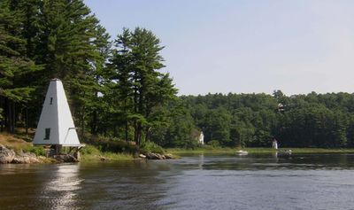
Fiddler's Reach Fog Signal, Historic fog signal station on Kennebec River, Arrowsic, United States.

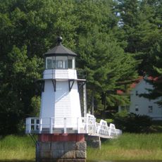
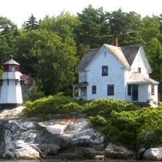
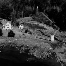
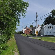
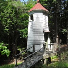
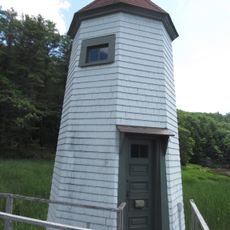
Fiddler's Reach Fog Signal is a pyramidal bell structure on the northern bank of the Kennebec River, marking a hazardous section of the waterway. The station sits where the river bends sharply, a location where boats often encountered danger.

The signal was built in 1914 after a steamship ran aground in the area, prompting the need for warning systems. The mechanical bell rang regularly to alert boats approaching the dangerous river bend.

People interested in maritime history visit to understand how river navigation was made safer through sound signals. The simple structure shows how communities worked to prevent accidents on busy waterways.

The location is relatively remote and situated on the riverbank, accessible from nearby local roads. Visitors should wear weather-appropriate clothing and be prepared for uneven terrain.

The original bell, which produced two distinct tones as a warning signal, is now housed at the Coast Guard Academy in Connecticut. This artifact is a rare remnant of early twentieth century maritime safety technology.

The community of curious travelers

AroundUs brings together thousands of curated places, local tips, and hidden gems, enriched daily by 60,000 contributors worldwide.

Start exploring
Location
GPS coordinates
43.88161,-69.79931
Latest update
December 14, 2025 18:02
Around this place
Maine Maritime Museum
United States of America

Maine Maritime Museum

2 km
Sagadahoc Bridge
United States of America

Sagadahoc Bridge

3.4 km
Carlton Bridge
United States of America

Carlton Bridge

3.4 km
Doubling Point Light
United States of America

Doubling Point Light

609 m
Hendricks Head Light
United States of America

Hendricks Head Light

11 km
Squirrel Point Light
United States of America

Squirrel Point Light

7.3 km
Perkins Island Light
United States of America

Perkins Island Light

10.6 km
Doubling Point Range Lights
United States of America

Doubling Point Range Lights

325 m
Hyde Mansion
United States of America

Hyde Mansion

3.3 km
Patten Free Library
United States of America

Patten Free Library

3.9 km
East Harpswell Free Will Baptist Church
United States of America

East Harpswell Free Will Baptist Church

9.2 km
John E.L. Huse Memorial School
United States of America

John E.L. Huse Memorial School

4.2 km
Bath Historic District
United States of America

Bath Historic District

4.3 km
Days Ferry Historic District
United States of America

Days Ferry Historic District

7.2 km
Gov. William King House
United States of America

Gov. William King House

6 km
William T. Donnell House
United States of America

William T. Donnell House

2.1 km
Captain Merritt House
United States of America

Captain Merritt House

3.3 km
Riggs-Zorach House
United States of America

Riggs-Zorach House

6.3 km
Heal Family House
United States of America

Heal Family House

6.9 km
W.D. Crooker House
United States of America

W.D. Crooker House

3.3 km
Randall-Hildreth House
United States of America

Randall-Hildreth House

10.8 km
Lt. Richard Hathorn House
United States of America

Lt. Richard Hathorn House

9.5 km
Benjamin Riggs House
United States of America

Benjamin Riggs House

5.9 km
Robinhood Free Meetinghouse
United States of America

Robinhood Free Meetinghouse

5.6 km
Mill Cove School
United States of America

Mill Cove School

4.1 km
Woolwich Town House
United States of America

Woolwich Town House

10.1 km
Doubling Point Rear Range Light
United States of America

Doubling Point Rear Range Light

363 m
Doubling Point Front Range Light
United States of America

Doubling Point Front Range Light

325 m
Show the full map
« Fiddler's Reach Fog Signal - Historic fog signal station on Kennebec River, Arrowsic, United States » is provided by Around Us (aroundus.com). Images and texts are derived from Wikimedia project under a Creative Commons license. You are allowed to copy, distribute, and modify copies of this page, under the conditions set by the license, as long as this note is clearly visible.

Discover hidden gems everywhere you go!

From secret cafés to breathtaking viewpoints, skip the crowded tourist spots and find places that match your style. Our app makes it easy with voice search, smart filtering, route optimization, and insider tips from travelers worldwide. Download now for the complete mobile experience.

Around Us App Screenshot

A unique approach to discovering new places

Le Figaro

All the places worth exploring

France Info

A tailor-made excursion in just a few clicks

20 Minutes

Around Us
Travel Guide & Maps
Download

Send to your phone

QR Code
1

Open the camera app on your mobile.

2

Point at the QR code with your camera. A notification will appear.

3

Tap the notification to open the link.