Enable Location

We need your location to show you interesting places around you

Discover nearby places

Find interesting locations and hidden gems around you

Precise directions

Get accurate directions and distances to places

Your location is never shared with other users. It's only used when you tap the location button.

Doubling Point Range Lights

Log in to your account

Start exploring — it's free

Trusted by 61,905 travelers worldwide

Continue with Google
Continue with Apple
or

We will send you a code to connect

By continuing, you accept our Terms and Conditions and our Privacy Policy

Check your inbox

We've sent a pincode in your inbox. Please enter the code below.

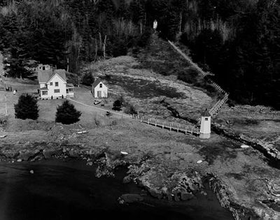
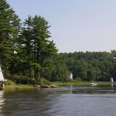
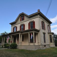
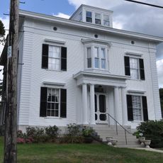
Doubling Point Range Lights, Navigation lights in Arrowsic, Maine, United States

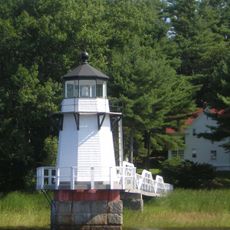
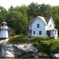
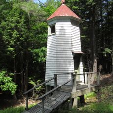
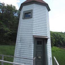
Doubling Point Range Lights are two octagonal wooden towers positioned on the banks of the Kennebec River, connected by walkways to the keeper's dwelling. The smaller structure aligns with the larger one to form a navigation system that guides vessels through the river's bends.

In 1898, these lights were constructed to safely guide ships through the winding Kennebec River where a major shipbuilding industry flourished. They represented part of broader river navigation improvements that made water transport in the region safer and more reliable.

These range lights represented the maritime backbone that allowed ships to navigate safely through one of Maine's most critical waterways. Today they stand as a reminder of how shipping shaped the region's economy and community identity.

The site is best viewed from the water and is commonly passed during river and boat tours. The best vantage point reveals the alignment of both towers as ship captains would have seen it for navigation purposes.

The larger tower measures about 17 feet (5 m) and the smaller about 13 feet (4 m), a precise height ratio that allowed sailors to recognize them correctly from great distances. This simple yet effective visual system required no complex lighting, just the correct geometric positioning.

The community of curious travelers

AroundUs brings together thousands of curated places, local tips, and hidden gems, enriched daily by 60,000 contributors worldwide.

Start exploring
Location
Inception
1898
GPS coordinates
43.88286,-69.79564
Latest update
December 14, 2025 15:02
Around this place
Coastal Maine Botanical Gardens
United States of America

Coastal Maine Botanical Gardens

10.8 km
Maine Maritime Museum
United States of America

Maine Maritime Museum

2.1 km
Sagadahoc Bridge
United States of America

Sagadahoc Bridge

3.4 km
Doubling Point Light
United States of America

Doubling Point Light

896 m
Carlton Bridge
United States of America

Carlton Bridge

3.3 km
Bosarge Family Education Center
United States of America

Bosarge Family Education Center

10.8 km
Squirrel Point Light
United States of America

Squirrel Point Light

7.4 km
Perkins Island Light
United States of America

Perkins Island Light

10.7 km
Fiddler's Reach Fog Signal
United States of America

Fiddler's Reach Fog Signal

325 m
Hyde Mansion
United States of America

Hyde Mansion

3.3 km
Patten Free Library
United States of America

Patten Free Library

3.9 km
East Harpswell Free Will Baptist Church
United States of America

East Harpswell Free Will Baptist Church

9.5 km
John E.L. Huse Memorial School
United States of America

John E.L. Huse Memorial School

4.2 km
Bath Historic District
United States of America

Bath Historic District

4.3 km
Days Ferry Historic District
United States of America

Days Ferry Historic District

7.1 km
Gov. William King House
United States of America

Gov. William King House

6 km
William T. Donnell House
United States of America

William T. Donnell House

2.2 km
Captain Merritt House
United States of America

Captain Merritt House

3.3 km
Riggs-Zorach House
United States of America

Riggs-Zorach House

6.2 km
Heal Family House
United States of America

Heal Family House

6.8 km
W.D. Crooker House
United States of America

W.D. Crooker House

3.3 km
Lt. Richard Hathorn House
United States of America

Lt. Richard Hathorn House

9.3 km
Benjamin Riggs House
United States of America

Benjamin Riggs House

5.7 km
Robinhood Free Meetinghouse
United States of America

Robinhood Free Meetinghouse

5.5 km
Mill Cove School
United States of America

Mill Cove School

4.4 km
Woolwich Town House
United States of America

Woolwich Town House

9.9 km
Doubling Point Rear Range Light
United States of America

Doubling Point Rear Range Light

50 m
Doubling Point Front Range Light
United States of America

Doubling Point Front Range Light

0 m
Show the full map
« Doubling Point Range Lights - Navigation lights in Arrowsic, Maine, United States » is provided by Around Us (aroundus.com). Images and texts are derived from Wikimedia project under a Creative Commons license. You are allowed to copy, distribute, and modify copies of this page, under the conditions set by the license, as long as this note is clearly visible.

Discover hidden gems everywhere you go!

From secret cafés to breathtaking viewpoints, skip the crowded tourist spots and find places that match your style. Our app makes it easy with voice search, smart filtering, route optimization, and insider tips from travelers worldwide. Download now for the complete mobile experience.

Around Us App Screenshot

A unique approach to discovering new places

Le Figaro

All the places worth exploring

France Info

A tailor-made excursion in just a few clicks

20 Minutes

Around Us
Travel Guide & Maps
Download

Send to your phone

QR Code
1

Open the camera app on your mobile.

2

Point at the QR code with your camera. A notification will appear.

3

Tap the notification to open the link.