Al Hudaydah Governorate
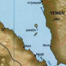
Al Hudaydah Governorate, Administrative division along the Red Sea coast, Yemen.
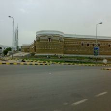
Al Hudaydah is an administrative region in western Yemen along the Red Sea coast. It comprises multiple districts with varied communities and landscapes that extend from the shoreline into inland areas.
The region developed as an important trade route between Africa and Arabia and was long governed under Ottoman rule. It took on its current administrative form following Yemen's unification in 1990.
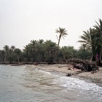
Fishing communities along the Red Sea coast maintain traditional harvesting methods that have been passed down through generations and shape daily life in the region. Their work reflects a deep connection to the sea that shapes the character of local villages and towns.
The region can be cool and windy along the coast while becoming hotter inland, so dress accordingly for varied conditions. Travel is generally easier during cooler months when exploring is more comfortable.
The city of Zabid within the region is recognized as a UNESCO World Heritage site and houses significant Islamic monuments, including the Great Mosque. These structures display architectural styles from different periods and preserve an important part of regional cultural history.
Location: Yemen
Capital city: Al Hudaydah
Elevation above the sea: 111 m
Shares border with: Dhamar Governorate, Hajjah Governorate, Ta'izz Governorate, Al Mahwit Governorate, Sanaa Governorate, Ibb Governorate, Raymah Governorate
GPS coordinates: 14.76667,43.25000
Latest update: December 23, 2025 11:58
Hanish Islands
125.4 km
Jabal al-Tair Island
174.9 kmJabal Bura
24.6 kmDubbi Volcano
204.1 km
Al Hudayda Castle
32.6 kmḨammām Maḩy ad Dīn
43.3 kmBura'a
38.8 kmJabal Miḩnah
38.8 kmBāb al ‘Ayn
56.2 kmAljubil
38.1 kmقرية بيت الصياد
58 kmالكتيب
36.6 kmAz Zaydiyah Fort
68.1 kmحوايج
33.2 kmالبرح
155.5 kmحماسه
57.3 kmوادي نعوم
57.6 kmTehamah Food
31.5 kmمنتزة الرمال الذهبية
31.8 kmبيت النهاري
59.8 kmقرية الهلج
38.7 kmصنيف عامر
58.1 kmبيت الصياد
57.5 kmBait Nasser
86.6 kmبني الأزرق
67.5 kmبيت شروف
86.9 kmطريق الراتة
58.7 kmالرحيبه
65.2 kmVisited this place? Tap the stars to rate it and share your experience / photos with the community! Try now! You can cancel it anytime.
Hays District
Al Mina District
Az Zuhrah District
As Sukhnah District
At Tuhayat District
As Salif District
Al Khawkhah District
Bajil District
Bayt Al Faqiah District
Bura District
Al Hawak
Al Mansuriyah District
Jabal Ra's District
Al Qanawis District
Al Hali District
Al Garrahi District
Al Hajjaylah District
Al Marawi'ah District
Az Zaydiyah District
Kamaran District
Al Munirah District
Ad Durayhimi District
Ad Dahi District
Al Mighlaf District
Zabid District
Alluheyah District
Discover hidden gems everywhere you go!
From secret cafés to breathtaking viewpoints, skip the crowded tourist spots and find places that match your style. Our app makes it easy with voice search, smart filtering, route optimization, and insider tips from travelers worldwide. Download now for the complete mobile experience.
A unique approach to discovering new places❞
— Le Figaro
All the places worth exploring❞
— France Info
A tailor-made excursion in just a few clicks❞
— 20 Minutes