Upper Volga Floodgate

Log in to your account

AroundUs is a community-driven map of interesting places, built by curious explorers like you. It grows with every review, story, and photo you share.
Connect to save your favorite spots, contribute locations, and create personalized routes.
Continue with Google
Continue with Apple
Continue with X
Continue with Facebook
Continue with email
By continuing, you accept our Terms and Conditions and our Privacy Policy
Create an account
Add to collection
Map
Suggest a change
Share

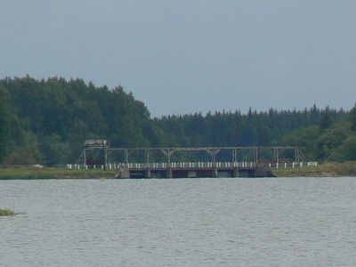
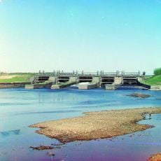
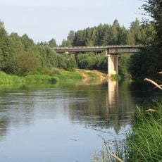
Upper Volga Floodgate, Water management structure in Selizharovsky District, Russia

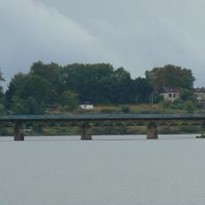
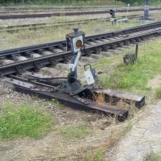
The Upper Volga Floodgate is a water control structure at the source of Europe's longest river, managing flow through a network of gates and concrete barriers. The facility also feeds water into the Moscow Canal, which supplies drinking water to the capital city.

The original dam was built in 1843 to improve navigation on the Volga and support trade routes. Soviet engineers later expanded and modernized the facility to generate electricity and supply water for major infrastructure projects like the Moscow Canal.

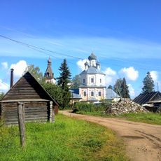
The structure reflects Soviet-era engineering approaches to river management and shaped how communities along the Volga adapted to controlled water flow. Visitors can observe how the facility became a landmark in the daily life of the surrounding region.

The floodgate is located in a rural area and is accessible to visitors interested in water management engineering and infrastructure projects. Spring through early autumn offers the best conditions for viewing, when weather is mild and the structure is easiest to observe.

The floodgate is part of the Big Volga project, a series of 11 dams that together supply a significant portion of the region's electricity grid. This engineering system unusually combines river management with large-scale power generation in a single interconnected network.

Location: Верхневолжский Бейшлот

Inception: 1843

GPS coordinates: 56.88589,33.31737

Latest update: December 11, 2025 11:05

Photos
Around this place
Upper Volga Reservoir
Russian Federation

Upper Volga Reservoir

8.5 km
Sig
Russian Federation

Sig

21.1 km
Church of the Ascension of Jesus Christ in Ostashkov
Russian Federation

Church of the Ascension of Jesus Christ in Ostashkov

32.2 km
Троицкий Селижаровский монастырь
Russian Federation

Троицкий Селижаровский монастырь

9 km
Борисовський міст (Тверська область)
Russian Federation

Борисовський міст (Тверська область)

25.3 km
Церковь Воскресения Христова (Селижарово)
Russian Federation

Церковь Воскресения Христова (Селижарово)

10.1 km
Ostashkov station water tower
Russian Federation

Ostashkov station water tower

30.1 km
Жилой дом (Осташков)
Russian Federation

Жилой дом (Осташков)

32.1 km
Ретирада (туалет) (Осташков)
Russian Federation

Ретирада (туалет) (Осташков)

30 km
Жилой дом (Селижарово)
Russian Federation

Жилой дом (Селижарово)

8.7 km
Будка «кипяток» (Осташков)
Russian Federation

Будка «кипяток» (Осташков)

30 km
Жилой дом (Осташков)
Russian Federation

Жилой дом (Осташков)

32.3 km
Жилой дом (Осташков)
Russian Federation

Жилой дом (Осташков)

32.2 km
Гидроколонка образца 1940-х гг. в западной (нечетной) горловине ж/д между путями №2 и №3 (Осташков)
Russian Federation

Гидроколонка образца 1940-х гг. в западной (нечетной) горловине ж/д между путями №2 и №3 (Осташков)

30.1 km
Склад (Осташков)
Russian Federation

Склад (Осташков)

29.9 km
Our Lady of Kazan church, Verkhniye Kotitsy
Russian Federation

Our Lady of Kazan church, Verkhniye Kotitsy

19.4 km
Жилой дом (Селижарово)
Russian Federation

Жилой дом (Селижарово)

8.9 km
Железнодорожное депо (Осташков)
Russian Federation

Железнодорожное депо (Осташков)

29.8 km
Контейнерный цех (Осташков)
Russian Federation

Контейнерный цех (Осташков)

29.8 km
Znamensky Convent (Ostashkov)
Russian Federation

Znamensky Convent (Ostashkov)

32.2 km
Church of the Transfiguration, Rogozha
Russian Federation

Church of the Transfiguration, Rogozha

23.7 km
Долговременная огневая точка (Любимка)
Russian Federation

Долговременная огневая точка (Любимка)

30.6 km
Здание вокзала (Осташков)
Russian Federation

Здание вокзала (Осташков)

30 km
Saints Peter and Paul church, Selizharovo
Russian Federation

Saints Peter and Paul church, Selizharovo

9 km
Жилой дом (Осташков)
Russian Federation

Жилой дом (Осташков)

32.2 km
Selishche Bridge
Russian Federation

Selishche Bridge

2.2 km
Керосиновый погреб (Осташков)
Russian Federation

Керосиновый погреб (Осташков)

30 km
Действующий стрелочный перевод 1930-х гг. с флюгарками у стрелочного поста в западной (нечетной) горловине (Осташков)
Russian Federation

Действующий стрелочный перевод 1930-х гг. с флюгарками у стрелочного поста в западной (нечетной) горловине (Осташков)

30.1 km
Show the full map
Reviews

Visited this place? Tap the stars to rate it and share your experience / photos with the community! Try now! You can cancel it anytime.

« Upper Volga Floodgate - Water management structure in Selizharovsky District, Russia » is provided by Around Us (aroundus.com). Images and texts are derived from Wikimedia project under a Creative Commons license. You are allowed to copy, distribute, and modify copies of this page, under the conditions set by the license, as long as this note is clearly visible.

Discover hidden gems everywhere you go!

From secret cafés to breathtaking viewpoints, skip the crowded tourist spots and find places that match your style. Our app makes it easy with voice search, smart filtering, route optimization, and insider tips from travelers worldwide. Download now for the complete mobile experience.

Around Us App Screenshot

A unique approach to discovering new places

Le Figaro

All the places worth exploring

France Info

A tailor-made excursion in just a few clicks

20 Minutes