Enable Location

We need your location to show you interesting places around you

Discover nearby places

Find interesting locations and hidden gems around you

Precise directions

Get accurate directions and distances to places

Your location is never shared with other users. It's only used when you tap the location button.

Marble Falls

Log in to your account

Start exploring — it's free

Trusted by 63,428 travelers worldwide

Continue with Google
Continue with Apple
or

We will send you a code to connect

By continuing, you accept our Terms and Conditions and our Privacy Policy

Check your inbox

We've sent a pincode in your inbox. Please enter the code below.

Discussion Reviews 2 Photos
48.2k Popularity

Marble Falls, City in Burnet County, Texas.

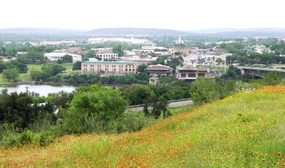
Marble Falls is a city in Burnet County, Texas, situated along the Colorado River where it has been dammed to create a large reservoir. The surrounding landscape features rolling hills and several lakes that define the Texas Hill Country region.

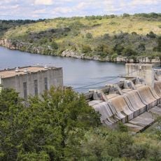
Adam Rankin Johnson, a former Confederate general, founded the settlement in 1887 as an industrial center powered by the river's water. The construction of the Max Starcke Dam in 1951 transformed the area by creating a large reservoir for water management and electricity generation.

In 1917, the citizens of Marble Falls made Texas history by electing Ophelia Crosby Harwood as the first woman mayor in the state.

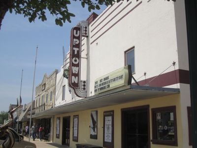
The town offers lake access with recreational opportunities like boating, fishing, and picnicking along the shoreline. Most amenities are centered near the waterfront or along the main road, so walking from one area to another is manageable and straightforward.

The original marble falls that gave the city its name now lie beneath the water of the reservoir, hidden since the dam construction in 1951. This submerged geological feature remains a quiet part of the town's story that visitors rarely think about when viewing the current water landscape.

The community of curious travelers

AroundUs brings together thousands of curated places, local tips, and hidden gems, enriched daily by 60,000 contributors worldwide.

Start exploring
Location
Inception
1887
Elevation above the sea
251 m
GPS coordinates
30.57417,-98.27806
Latest update
December 14, 2025 19:14
Around this place
United States of America

Lake Lyndon B. Johnson

6.1 km
Longhorn Cavern State Park
United States of America

Longhorn Cavern State Park

14.1 km
Max Starcke Dam
United States of America

Max Starcke Dam

2.8 km
Roper Hotel
United States of America

Roper Hotel

432 m
Longhorn Cavern Administration Building
United States of America

Longhorn Cavern Administration Building

14.1 km
United States of America

Eagle Bluffs

14.5 km
United States of America

Post Office Building

231 m
United States of America

Henry Thomas Lodge, A.F. & A.M.

11.1 km
United States of America

Governor O. M. Roberts' House

369 m
United States of America

Christian-Matern House

597 m
United States of America

Hoag-Faubion-Fuchs House

696 m
United States of America

Round Mountain Stage-Coach Inn and Stable

17.3 km
United States of America

Joseph and Eliza Bird Residence

17.1 km
United States of America

Brandt Badger House

980 m
United States of America

Crownover Chapel

7.7 km
United States of America

Ram Rock

12.6 km
United States of America

Slick Rock Golf Course

11.4 km
United States of America

Slick Rock Golf Course

9.5 km
United States of America

Summit Rock

11.4 km
United States of America

Apple Rock

12.3 km
Lake Marble Falls
United States of America

Lake Marble Falls

2.9 km
United States of America

Escondido Golf & Lake Club

11 km
United States of America

Slick Rock

9.5 km
United States of America

Uptown Theatre

260 m
United States of America

Bernie's Art Gallery & Custom Frame Shop

284 m

Marta Stafford Fine Art

326 m
United States of America

Highland Arts Guild

187 m
United States of America

Dino Falls Roller Coaster of Fun & Picnic Area

14.2 km
Show the full map
Reviews
Share your experience

No review yet

Discussions
Start a discussion...

No discussion yet

« Marble Falls - City in Burnet County, Texas » is provided by Around Us (aroundus.com). Images and texts are derived from Wikimedia project under a Creative Commons license. You are allowed to copy, distribute, and modify copies of this page, under the conditions set by the license, as long as this note is clearly visible.

Discover hidden gems everywhere you go!

From secret cafés to breathtaking viewpoints, skip the crowded tourist spots and find places that match your style. Our app makes it easy with voice search, smart filtering, route optimization, and insider tips from travelers worldwide. Download now for the complete mobile experience.

Around Us App Screenshot

A unique approach to discovering new places

Le Figaro

All the places worth exploring

France Info

A tailor-made excursion in just a few clicks

20 Minutes

Around Us
Travel Guide & Maps
Download

Send to your phone

QR Code
1

Open the camera app on your mobile.

2

Point at the QR code with your camera. A notification will appear.

3

Tap the notification to open the link.