Enable Location

We need your location to show you interesting places around you

Discover nearby places

Find interesting locations and hidden gems around you

Precise directions

Get accurate directions and distances to places

Your location is never shared with other users. It's only used when you tap the location button.

Butler County

Log in to your account

Start exploring — it's free

Trusted by 62,827 travelers worldwide

Continue with Google
Continue with Apple
or

We will send you a code to connect

By continuing, you accept our Terms and Conditions and our Privacy Policy

Check your inbox

We've sent a pincode in your inbox. Please enter the code below.

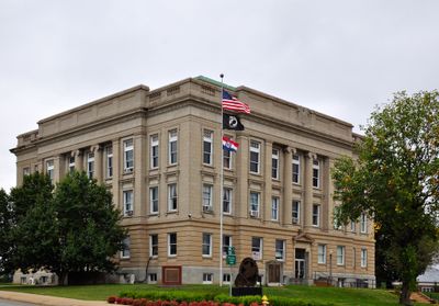
Butler County, County seat in Southeast Missouri, United States

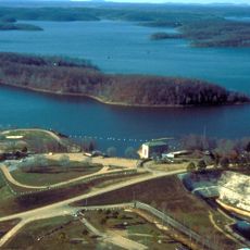
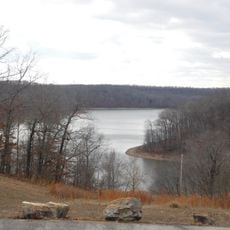
Butler County is an administrative division in Southeast Missouri spanning about 700 square miles across the Ozark Foothills region. It contains portions of Mark Twain National Forest and several waterways, including Wappapello Lake.

The county was organized from Wayne County in February 1849 and named after William O. Butler, a former United States Representative. This establishment was part of the broader settlement and development of Missouri during the 19th century expansion.

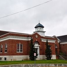
The region has deep Christian traditions shaped by evangelical churches, particularly Baptist congregations that have long anchored community life. These places of worship remain central gathering spaces for locals.

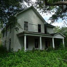
The area is sparsely populated with Poplar Bluff as the main town and administrative center, so expect longer travel times between destinations. Visitors should plan ahead as services and amenities are spread throughout the region rather than concentrated.

Wolf Creek Recreation Area offers more than 20 miles of developed hiking trails winding through forest landscapes and along rivers. This extensive network allows visitors to experience the region's natural setting on well-maintained paths.

The community of curious travelers

AroundUs brings together thousands of curated places, local tips, and hidden gems, enriched daily by 60,000 contributors worldwide.

Start exploring
Location
Inception
February 27, 1849
Capital city
Poplar Bluff
Shares border with
Wayne County, Clay County, Dunklin County, Stoddard County, Carter County, Ripley County
GPS coordinates
36.72000,-90.40000
Latest update
December 7, 2025 20:41
Around this place
Lake Wappapello
United States of America

Lake Wappapello

23.3 km
Mingo National Wildlife Refuge
United States of America

Mingo National Wildlife Refuge

35.7 km
Rodgers Theatre
United States of America

Rodgers Theatre

4.2 km
Morris State Park
United States of America

Morris State Park

36.7 km
Hargrove Pivot Bridge
United States of America

Hargrove Pivot Bridge

12.1 km
Williams-Gierth House
United States of America

Williams-Gierth House

4.2 km
North Main Street Historic District
United States of America

North Main Street Historic District

4.5 km
Mark Twain School
United States of America

Mark Twain School

5.1 km
Thomas Moore House
United States of America

Thomas Moore House

4.5 km
Wright-Dalton-Bell-Anchor Department Store Building
United States of America

Wright-Dalton-Bell-Anchor Department Store Building

4 km
Sheeks House
United States of America

Sheeks House

38.7 km
Butler County Courthouse
United States of America

Butler County Courthouse

4.1 km
Oliver House
United States of America

Oliver House

38.1 km
Poplar Bluff Public Library
United States of America

Poplar Bluff Public Library

4.3 km
John Archibald Phillips House
United States of America

John Archibald Phillips House

3.8 km
Alfred W. Greer House
United States of America

Alfred W. Greer House

4.6 km
Moore-Dalton House
United States of America

Moore-Dalton House

4.5 km
Garfield Historic District
United States of America

Garfield Historic District

5 km
St. Louis-San Francisco Railroad Depot
United States of America

St. Louis-San Francisco Railroad Depot

3.8 km
Ripley County Jail, Sheriff's Office and Sheriff's Residence
United States of America

Ripley County Jail, Sheriff's Office and Sheriff's Residence

39.9 km
Randolph Columbus Barrett House
United States of America

Randolph Columbus Barrett House

39.4 km
Wheatley Public School
United States of America

Wheatley Public School

5 km
J. Herbert Moore House
United States of America

J. Herbert Moore House

5.2 km
Ripley County Courthouse
United States of America

Ripley County Courthouse

39.8 km
Williamson-Kennedy School
United States of America

Williamson-Kennedy School

4.6 km
Baynham House
United States of America

Baynham House

41.7 km
Clay County Courthouse, Western District
United States of America

Clay County Courthouse, Western District

38.8 km
Lake Wappapello State Park
United States of America

Lake Wappapello State Park

26.6 km
Show the full map
Administrative divisions
« Butler County - County seat in Southeast Missouri, United States » is provided by Around Us (aroundus.com). Images and texts are derived from Wikimedia project under a Creative Commons license. You are allowed to copy, distribute, and modify copies of this page, under the conditions set by the license, as long as this note is clearly visible.

Discover hidden gems everywhere you go!

From secret cafés to breathtaking viewpoints, skip the crowded tourist spots and find places that match your style. Our app makes it easy with voice search, smart filtering, route optimization, and insider tips from travelers worldwide. Download now for the complete mobile experience.

Around Us App Screenshot

A unique approach to discovering new places

Le Figaro

All the places worth exploring

France Info

A tailor-made excursion in just a few clicks

20 Minutes

Around Us
Travel Guide & Maps
Download

Send to your phone

QR Code
1

Open the camera app on your mobile.

2

Point at the QR code with your camera. A notification will appear.

3

Tap the notification to open the link.