Enable Location

We need your location to show you interesting places around you

Discover nearby places

Find interesting locations and hidden gems around you

Precise directions

Get accurate directions and distances to places

Your location is never shared with other users. It's only used when you tap the location button.

Morris State Park

Log in to your account

Start exploring — it's free

Trusted by 61,899 travelers worldwide

Continue with Google
Continue with Apple
or

We will send you a code to connect

By continuing, you accept our Terms and Conditions and our Privacy Policy

Check your inbox

We've sent a pincode in your inbox. Please enter the code below.

Morris State Park

Morris State Park, State park in Dunklin County, United States.

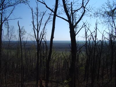
Morris State Park is a conservation area in Dunklin County covering about 161 acres with a 2.25-mile loop trail winding through the terrain. The trail passes through varied geological features on Crowley's Ridge and the park includes picnic areas and parking throughout the grounds.

The park was established in 2000 after businessman Jim D. Morris donated land to the state of Missouri. This gift transformed the area into a publicly accessible natural preserve.

The park offers a place where visitors can walk through and observe the natural geology that shapes this region of Missouri. People come here to experience the distinct landscape and understand how the terrain differs from surrounding areas.

The park is open year-round and the loop trail is easy to navigate for most visitors regardless of experience level. Spring through fall are ideal times to visit when weather is mild and the landscape is most active.

The park protects a section of Crowley's Ridge, a geographical rise that stands roughly 200 feet above the Mississippi River floodplain. This elevation develops from distinct soil types that set this area apart from the surrounding flat landscape.

The community of curious travelers

AroundUs brings together thousands of curated places, local tips, and hidden gems, enriched daily by 60,000 contributors worldwide.

Start exploring
Location
Inception
2000
GPS coordinates
36.55360,-90.04470
Latest update
December 14, 2025 11:40
Around this place
Lake Wappapello
United States of America

Lake Wappapello

47.4 km
Mingo National Wildlife Refuge
United States of America

Mingo National Wildlife Refuge

47 km
Pfeiffer House and Carriage House
United States of America

Pfeiffer House and Carriage House

23.4 km
Rodgers Theatre
United States of America

Rodgers Theatre

38.5 km
Hargrove Pivot Bridge
United States of America

Hargrove Pivot Bridge

25.1 km
Stoddard County Courthouse
United States of America

Stoddard County Courthouse

38.2 km
Williams-Gierth House
United States of America

Williams-Gierth House

39.1 km
North Main Street Historic District
United States of America

North Main Street Historic District

38.8 km
Mark Twain School
United States of America

Mark Twain School

39.7 km
Thomas Moore House
United States of America

Thomas Moore House

38.7 km
Wright-Dalton-Bell-Anchor Department Store Building
United States of America

Wright-Dalton-Bell-Anchor Department Store Building

38.4 km
Butler County Courthouse
United States of America

Butler County Courthouse

38.4 km
Oliver House
United States of America

Oliver House

50.4 km
Poplar Bluff Public Library
United States of America

Poplar Bluff Public Library

38.5 km
John Archibald Phillips House
United States of America

John Archibald Phillips House

38.6 km
Alfred W. Greer House
United States of America

Alfred W. Greer House

39.4 km
Moore-Dalton House
United States of America

Moore-Dalton House

38.7 km
Garfield Historic District
United States of America

Garfield Historic District

39.3 km
St. Louis-San Francisco Railroad Depot
United States of America

St. Louis-San Francisco Railroad Depot

38.5 km
Wheatley Public School
United States of America

Wheatley Public School

39.3 km
J. Herbert Moore House
United States of America

J. Herbert Moore House

37.3 km
Charles and Bettie Birthright House
United States of America

Charles and Bettie Birthright House

13.4 km
Williamson-Kennedy School
United States of America

Williamson-Kennedy School

38.6 km
Knob School
United States of America

Knob School

47.3 km
Piggott National Guard Armory
United States of America

Piggott National Guard Armory

22.6 km
Piggott Commercial Historic District
United States of America

Piggott Commercial Historic District

23.1 km
Clay County Courthouse, Eastern District
United States of America

Clay County Courthouse, Eastern District

23.2 km
Hunter-Dawson State Historic Site
United States of America

Hunter-Dawson State Historic Site

46.8 km
Show the full map
« Morris State Park - State park in Dunklin County, United States » is provided by Around Us (aroundus.com). Images and texts are derived from Wikimedia project under a Creative Commons license. You are allowed to copy, distribute, and modify copies of this page, under the conditions set by the license, as long as this note is clearly visible.

Discover hidden gems everywhere you go!

From secret cafés to breathtaking viewpoints, skip the crowded tourist spots and find places that match your style. Our app makes it easy with voice search, smart filtering, route optimization, and insider tips from travelers worldwide. Download now for the complete mobile experience.

Around Us App Screenshot

A unique approach to discovering new places

Le Figaro

All the places worth exploring

France Info

A tailor-made excursion in just a few clicks

20 Minutes

Around Us
Travel Guide & Maps
Download

Send to your phone

QR Code
1

Open the camera app on your mobile.

2

Point at the QR code with your camera. A notification will appear.

3

Tap the notification to open the link.