Enable Location

We need your location to show you interesting places around you

Discover nearby places

Find interesting locations and hidden gems around you

Precise directions

Get accurate directions and distances to places

Your location is never shared with other users. It's only used when you tap the location button.

San Germán

Log in to your account

Start exploring — it's free

Trusted by 61,921 travelers worldwide

Continue with Google
Continue with Apple
or

We will send you a code to connect

By continuing, you accept our Terms and Conditions and our Privacy Policy

Check your inbox

We've sent a pincode in your inbox. Please enter the code below.

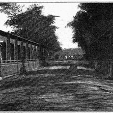
San Germán, Administrative region in southwestern Puerto Rico.

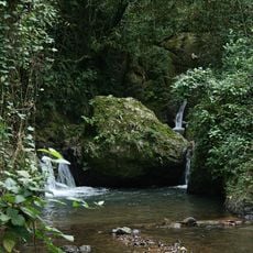
San Germán is a municipality in southwestern Puerto Rico that spreads across hills and valleys, blending residential neighborhoods with agricultural areas and commercial zones. The town displays this mix through its varied layout, using the terrain's natural features in different ways.

Juan Ponce de León founded this settlement in 1511 as one of the island's earliest European outposts. The community retained its importance over the centuries and helped shape the region's economic and social development.

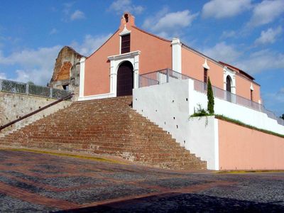
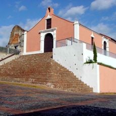
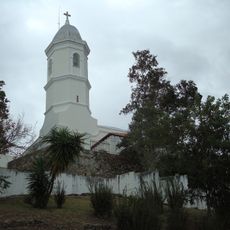
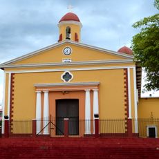
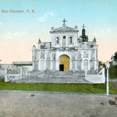
The Porta Coeli Church anchors the town center and displays religious artwork spanning several centuries. Visitors can observe these pieces to understand the spiritual traditions that shaped the community.

The town is accessible via the PR-2 highway, with several guesthouses and restaurants near the central plaza area. Visitors will also find smaller hotels and cafés that provide everything needed for a comfortable stay.

The Porta Coeli Church, built in 1606, ranks among the oldest surviving churches in the Western Hemisphere. Its construction and preservation demonstrate how early religious buildings used techniques and materials of their era to endure to the present day.

The community of curious travelers

AroundUs brings together thousands of curated places, local tips, and hidden gems, enriched daily by 60,000 contributors worldwide.

Start exploring
Location
Inception
0001-01-01
Capital city
San Germán
Elevation above the sea
84 m
Shares border with
Maricao, Cabo Rojo, Lajas, Sabana Grande, Hormigueros, Mayagüez
GPS coordinates
18.07892,-67.04074
Latest update
December 20, 2025 01:46
Around this place
Porta Coeli
United States of America

Porta Coeli

730 m
Maricao State Forest
United States of America

Maricao State Forest

8.5 km
Minor Basilica of the Virgin of Montserrat
United States of America

Minor Basilica of the Virgin of Montserrat

11.6 km
San Isidro Labrador y Santa María de la Cabeza Church
United States of America

San Isidro Labrador y Santa María de la Cabeza Church

8.5 km
San Germán de Auxerre Church
United States of America

San Germán de Auxerre Church

746 m
Sabana Grande Masonic Cemetery
United States of America

Sabana Grande Masonic Cemetery

7.8 km
United States of America

Ponce de León House

5.9 km
Silva Bridge
United States of America

Silva Bridge

13 km
United States of America

Lassise-Schettini House

8.7 km
United States of America

Torréns Bridge

10.2 km
Salto Curet Waterfall
United States of America

Salto Curet Waterfall

13.3 km
United States of America

Laguna Cartagena National Wildlife Refuge

9.7 km
United States of America

Área Recreativa Orlando López Martínez

8.7 km
United States of America

Caribbean Cinemas San German 6

476 m
United States of America

Imagen de San José con el Niño Jesús

712 m
United States of America

Monte Estado

9.7 km

Teatro Adalberto Rodríguez Machuchal

8.5 km
United States of America

Teatro Juanita Arenas

11.4 km
United States of America

Teatro Sol

473 m
United States of America

Piscina de Olas

2.2 km
United States of America

Estatua de Ángel Casto Pérez

1.1 km
United States of America

Dr. John Will Harris Statue

940 m
United States of America

Estatua de San José

707 m
United States of America

Estatua de la Inmaculada Concepción

2.2 km

Work of art, sculpture

13.2 km

Work of art, sculpture

13 km

Mirador Falcón de Sierra

9.5 km

Mirador del Guaraguao

9.4 km
Show the full map
« San Germán - Administrative region in southwestern Puerto Rico » is provided by Around Us (aroundus.com). Images and texts are derived from Wikimedia project under a Creative Commons license. You are allowed to copy, distribute, and modify copies of this page, under the conditions set by the license, as long as this note is clearly visible.

Discover hidden gems everywhere you go!

From secret cafés to breathtaking viewpoints, skip the crowded tourist spots and find places that match your style. Our app makes it easy with voice search, smart filtering, route optimization, and insider tips from travelers worldwide. Download now for the complete mobile experience.

Around Us App Screenshot

A unique approach to discovering new places

Le Figaro

All the places worth exploring

France Info

A tailor-made excursion in just a few clicks

20 Minutes

Around Us
Travel Guide & Maps
Download

Send to your phone

QR Code
1

Open the camera app on your mobile.

2

Point at the QR code with your camera. A notification will appear.

3

Tap the notification to open the link.