Chest opened
+${chestReward.xp} XP
Explorer
NOUVEAU ×${chestReward.collectible.quantity}
tapez pour fermer
Chest locked

Open chests in the app

Around Us is built for your phone — chests unlock when you walk, explore and capture nearby places.

Enable Location

We need your location to show you interesting places around you

Discover nearby places

Find interesting locations and hidden gems around you

Precise directions

Get accurate directions and distances to places

Your location is never shared with other users. It's only used when you tap the location button.

Devil's Tramping Ground

Log in to your account

Start exploring — it's free

Trusted by 72,887 travelers worldwide

Continue with Google
Continue with Apple
or

We will send you a code to connect

By continuing, you accept our Terms and Conditions and our Privacy Policy

Check your inbox

We've sent a pincode in your inbox. Please enter the code below.

Devil's Tramping Ground
Discussion Reviews 1 Photos
87.5k Popularity

Devil's Tramping Ground, Circular barren ground in Chatham County, United States.

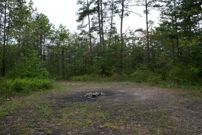
The Devil's Tramping Ground is a circular bare patch in a forest in Chatham County, North Carolina, measuring about 12 meters (40 feet) across. No grass or other greenery grows within this boundary, while the rest of the forest appears normally vegetated.

The spot was mentioned by early settlers in the 18th century, who described the ground as infertile. Since then, the circle has remained largely unchanged and continues to puzzle visitors and researchers.

The name comes from stories claiming that strange sounds can be heard at night, giving the location a long tradition of local storytelling. Residents visit the circle after sunset and observe the bare ground that contrasts with the surrounding forest area.

Access to the spot is via a forest trail that can become slippery when wet, so sturdy shoes are recommended. The circle itself lies a few meters off the main path and is reached by a narrow trail.

The soil inside the circle contains more salt than the earth around it, which prevents plant growth. This chemical peculiarity persists despite decades of attempts to plant or alter the ground.

The community of curious travelers

AroundUs brings together thousands of curated places, local tips, and hidden gems, enriched daily by 60,000 contributors worldwide.

Start exploring
Location
Diameter
12 m
GPS coordinates
35.58480,-79.48700
Latest update
December 13, 2025 15:58
Around this place
North Carolina Zoo
United States of America

North Carolina Zoo

25.6 km
House in the Horseshoe
United States of America

House in the Horseshoe

16.1 km
Deep River Camelback Truss Bridge
United States of America

Deep River Camelback Truss Bridge

22.3 km
Temple Theater
United States of America

Temple Theater

30.2 km
Chatham County Courthouse
United States of America

Chatham County Courthouse

31.8 km
Railroad House
United States of America

Railroad House

30.3 km
Moore County Courthouse
United States of America

Moore County Courthouse

27.4 km
Buffalo Presbyterian Church and Cemeteries
United States of America

Buffalo Presbyterian Church and Cemeteries

29.9 km
Carthage Historic District
United States of America

Carthage Historic District

26.7 km
Marley House
United States of America

Marley House

18.7 km
J.C. Black House
United States of America

J.C. Black House

27.4 km
Lee County Training School
United States of America

Lee County Training School

30.2 km
Alexander Kelly House
United States of America

Alexander Kelly House

23.5 km
Euphronia Presbyterian Church
United States of America

Euphronia Presbyterian Church

17.9 km
Lewis Freeman House
United States of America

Lewis Freeman House

31.6 km
Liberty Historic District
United States of America

Liberty Historic District

31.2 km
Hawkins Avenue Historic District
United States of America

Hawkins Avenue Historic District

29.9 km
A. P. Terry House
United States of America

A. P. Terry House

30.9 km
Coleridge Historic District
United States of America

Coleridge Historic District

13.2 km
Sanford High School, Former
United States of America

Sanford High School, Former

29.6 km
James Bryant House
United States of America

James Bryant House

30.1 km
Siler City Commercial Historic District
United States of America

Siler City Commercial Historic District

15.5 km
Reid House
United States of America

Reid House

31.7 km
East Sanford Historic District
United States of America

East Sanford Historic District

31.1 km
Henry Adolphus London House
United States of America

Henry Adolphus London House

31.3 km
London Cottage
United States of America

London Cottage

31.4 km
Rosemount-McIver Park Historic District
United States of America

Rosemount-McIver Park Historic District

29.6 km
Bruce-Dowd-Kennedy House
United States of America

Bruce-Dowd-Kennedy House

27.8 km
Show the full map
Reviews
Share your experience

No review yet

Discussions
Start a discussion...

No discussion yet

« Devil's Tramping Ground - Circular barren ground in Chatham County, United States » is provided by Around Us (aroundus.com). Images and texts are derived from Wikimedia project under a Creative Commons license. You are allowed to copy, distribute, and modify copies of this page, under the conditions set by the license, as long as this note is clearly visible.

Discover hidden gems everywhere you go!

From secret cafés to breathtaking viewpoints, skip the crowded tourist spots and find places that match your style. Our app makes it easy with voice search, smart filtering, route optimization, and insider tips from travelers worldwide. Download now for the complete mobile experience.

Around Us App Screenshot

A unique approach to discovering new places

Le Figaro

All the places worth exploring

France Info

A tailor-made excursion in just a few clicks

20 Minutes

Around Us
Travel Guide & Maps
Download

Send to your phone

QR Code
1

Open the camera app on your mobile.

2

Point at the QR code with your camera. A notification will appear.

3

Tap the notification to open the link.