Chest opened
+${chestReward.xp} XP
Explorer
NOUVEAU ×${chestReward.collectible.quantity}
tapez pour fermer
Chest locked

Open chests in the app

Around Us is built for your phone — chests unlock when you walk, explore and capture nearby places.

Enable Location

We need your location to show you interesting places around you

Discover nearby places

Find interesting locations and hidden gems around you

Precise directions

Get accurate directions and distances to places

Your location is never shared with other users. It's only used when you tap the location button.

Tunnel Hill

Log in to your account

Start exploring — it's free

Trusted by 72,882 travelers worldwide

Continue with Google
Continue with Apple
or

We will send you a code to connect

By continuing, you accept our Terms and Conditions and our Privacy Policy

Check your inbox

We've sent a pincode in your inbox. Please enter the code below.

Discussion Reviews 1 Photos
12k Popularity

Tunnel Hill, Administrative division in Whitfield County, Georgia, United States.

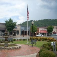
Tunnel Hill is a town located across Whitfield and Catoosa counties in northwestern Georgia, situated northwest of Dalton. The community spreads across an area shaped by the natural terrain and local infrastructure patterns.

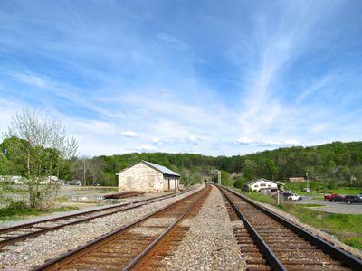
The settlement was incorporated by the Georgia General Assembly in 1848 as Tunnelsville and renamed Tunnel Hill in 1856. The name change reflected the importance of the railway tunnel that was cut through the nearby mountain.

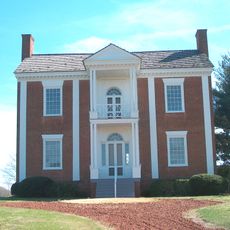
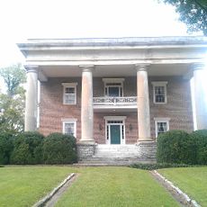
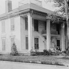
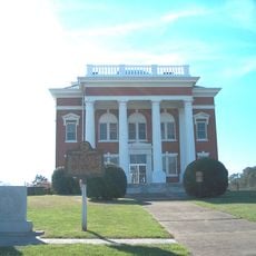
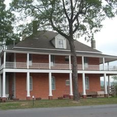
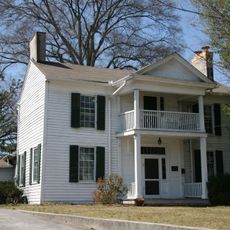
The Clisby Austin House served as a command center where General William T. Sherman developed strategies during the Civil War. Today, this building stands as a reminder of how military decisions shaped the local area.

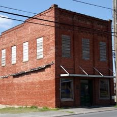
The town operates with basic municipal services managed by local government and serves a small residential population. Visitors will find a compact community with typical small-town amenities and access points.

A railroad tunnel cut through Chetoogeta Mountain in the 1840s shaped the founding and growth of the entire settlement. This engineering project remains visible in the landscape and continues to influence local transportation routes.

The community of curious travelers

AroundUs brings together thousands of curated places, local tips, and hidden gems, enriched daily by 60,000 contributors worldwide.

Start exploring
GPS coordinates
34.84063,-85.04273
Latest update
December 7, 2025 20:47
Around this place
United States of America

Lake Winnepesaukah

24 km
Wilder Brigade Monument
United States of America

Wilder Brigade Monument

22.3 km
Chief Vann House Historic Site
United States of America

Chief Vann House Historic Site

21.9 km
Fort Oglethorpe
United States of America

Fort Oglethorpe

22.9 km
Brainerd Mission
United States of America

Brainerd Mission

24.4 km
Cannon Ball
United States of America

Cannon Ball

24 km
Gordon-Lee Mansion
United States of America

Gordon-Lee Mansion

23.3 km
Jones Observatory
United States of America

Jones Observatory

26.4 km
Red Clay State Park
United States of America

Red Clay State Park

19.1 km
Champy's Chicken
United States of America

Champy's Chicken

22.4 km
Marsh-Warthen House
United States of America

Marsh-Warthen House

26.3 km
Prater's Mill
United States of America

Prater's Mill

12.8 km
James County Courthouse
United States of America

James County Courthouse

25.8 km
Lee and Gordon Mill
United States of America

Lee and Gordon Mill

21 km
Sir Goony's Family Fun Center
United States of America

Sir Goony's Family Fun Center

24.5 km
Masonic Lodge No. 238
United States of America

Masonic Lodge No. 238

10.8 km
Murray County Courthouse
United States of America

Murray County Courthouse

26.2 km
Dalton Commercial Historic District
United States of America

Dalton Commercial Historic District

10.3 km
Chickamauga Coal and Iron Company Coke Ovens
United States of America

Chickamauga Coal and Iron Company Coke Ovens

23.5 km
Catoosa County Courthouse
United States of America

Catoosa County Courthouse

10.4 km
Chickamauga Lodge No. 221, Free and Accepted Masons, Prince Hall Affiliate
United States of America

Chickamauga Lodge No. 221, Free and Accepted Masons, Prince Hall Affiliate

24.1 km
Chickamauga Historic District
United States of America

Chickamauga Historic District

23.2 km
Wright Hotel
United States of America

Wright Hotel

26.4 km
Thomas A. Berry House
United States of America

Thomas A. Berry House

10.3 km
Ainsworth E. Blunt House
United States of America

Ainsworth E. Blunt House

10.4 km
Ringgold Commercial Historic District
United States of America

Ringgold Commercial Historic District

10.3 km
Lee & Gordon's Mills
United States of America

Lee & Gordon's Mills

21 km
Chickamauga Battlefield Visitor Center
United States of America

Chickamauga Battlefield Visitor Center

22.7 km
Show the full map
Reviews
Share your experience

No review yet

Discussions
Start a discussion...

No discussion yet

« Tunnel Hill - Administrative division in Whitfield County, Georgia, United States » is provided by Around Us (aroundus.com). Images and texts are derived from Wikimedia project under a Creative Commons license. You are allowed to copy, distribute, and modify copies of this page, under the conditions set by the license, as long as this note is clearly visible.

Discover hidden gems everywhere you go!

From secret cafés to breathtaking viewpoints, skip the crowded tourist spots and find places that match your style. Our app makes it easy with voice search, smart filtering, route optimization, and insider tips from travelers worldwide. Download now for the complete mobile experience.

Around Us App Screenshot

A unique approach to discovering new places

Le Figaro

All the places worth exploring

France Info

A tailor-made excursion in just a few clicks

20 Minutes

Around Us
Travel Guide & Maps
Download

Send to your phone

QR Code
1

Open the camera app on your mobile.

2

Point at the QR code with your camera. A notification will appear.

3

Tap the notification to open the link.