Enable Location

We need your location to show you interesting places around you

Discover nearby places

Find interesting locations and hidden gems around you

Precise directions

Get accurate directions and distances to places

Your location is never shared with other users. It's only used when you tap the location button.

Jay Peak

Log in to your account

Start exploring — it's free

Trusted by 62,281 travelers worldwide

Continue with Google
Continue with Apple
or

We will send you a code to connect

By continuing, you accept our Terms and Conditions and our Privacy Policy

Check your inbox

We've sent a pincode in your inbox. Please enter the code below.

Jay Peak

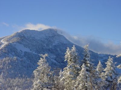
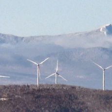
Jay Peak, Mountain summit in Westfield, United States

Jay Peak is a mountain in Vermont's Green Mountains near the Canadian border, rising to 3,862 feet (1,177 meters). The ski resort spans 385 acres with 81 trails designed for different skill levels.

Harold Haynes carved the first ski trails in 1955 and installed a T-bar lift before opening the resort for winter sports in 1957. The mountain has since grown into a major New England ski destination.

The mountain and surrounding municipality received their names in recognition of John Jay, an American statesman who served from 1745 to 1829.

The ski season begins around Thanksgiving weekend with ticket options available for different visit lengths. The mountain sits near the Canadian border and is accessible from major towns throughout Vermont.

This area receives the highest snowfall in the northeastern United States, averaging 359 inches of natural snow each year. These abundant snow amounts create excellent conditions throughout the winter season.

The community of curious travelers

AroundUs brings together thousands of curated places, local tips, and hidden gems, enriched daily by 60,000 contributors worldwide.

Start exploring
Location
GPS coordinates
44.92423,-72.52569
Latest update
December 7, 2025 20:49
Around this place
Big Jay
United States of America

Big Jay

1.6 km
St. Mary Star of the Sea
United States of America

St. Mary Star of the Sea

24.6 km
Goodrich Memorial Library
United States of America

Goodrich Memorial Library

24.9 km
Sweat-Comings Company House
United States of America

Sweat-Comings Company House

14.2 km
Holy Transfiguration skete
Canada

Holy Transfiguration skete

14.1 km
Hutchins Covered Bridge
United States of America

Hutchins Covered Bridge

10 km
West Hill Covered Bridge
United States of America

West Hill Covered Bridge

11.5 km
Longley Covered Bridge
United States of America

Longley Covered Bridge

10.4 km
Enosburg Congregational Memorial Church
United States of America

Enosburg Congregational Memorial Church

18.6 km
Comstock Covered Bridge
United States of America

Comstock Covered Bridge

9.7 km
Fuller Covered Bridge
United States of America

Fuller Covered Bridge

9.3 km
River Road Covered Bridge
United States of America

River Road Covered Bridge

10.9 km
Sheldon Boright House
United States of America

Sheldon Boright House

14.4 km
St. Ann's Episcopal Church
United States of America

St. Ann's Episcopal Church

14.2 km
Hectorville Covered Bridge
United States of America

Hectorville Covered Bridge

10.5 km
Orne Covered Bridge
United States of America

Orne Covered Bridge

21 km
Bridge 12
United States of America

Bridge 12

18.3 km
Enosburg Opera House
United States of America

Enosburg Opera House

21.9 km
Newport Downtown Historic District
United States of America

Newport Downtown Historic District

24.9 km
United States Courthouse, Post Office and Customs House
United States of America

United States Courthouse, Post Office and Customs House

24.8 km
Montgomery House
United States of America

Montgomery House

9.4 km
Pont de la Frontière
Canada

Pont de la Frontière

15.4 km
West Berkshire School
United States of America

West Berkshire School

23.4 km
F.W. Wheeler House
United States of America

F.W. Wheeler House

14.1 km
Richford Primary School
United States of America

Richford Primary School

14.3 km
Billado Block
United States of America

Billado Block

22.1 km
Hopkins Covered Bridge
United States of America

Hopkins Covered Bridge

11.6 km
Grange ronde de Mansonville
Canada

Grange ronde de Mansonville

17.7 km
Show the full map
« Jay Peak - Mountain summit in Westfield, United States » is provided by Around Us (aroundus.com). Images and texts are derived from Wikimedia project under a Creative Commons license. You are allowed to copy, distribute, and modify copies of this page, under the conditions set by the license, as long as this note is clearly visible.

Discover hidden gems everywhere you go!

From secret cafés to breathtaking viewpoints, skip the crowded tourist spots and find places that match your style. Our app makes it easy with voice search, smart filtering, route optimization, and insider tips from travelers worldwide. Download now for the complete mobile experience.

Around Us App Screenshot

A unique approach to discovering new places

Le Figaro

All the places worth exploring

France Info

A tailor-made excursion in just a few clicks

20 Minutes

Around Us
Travel Guide & Maps
Download

Send to your phone

QR Code
1

Open the camera app on your mobile.

2

Point at the QR code with your camera. A notification will appear.

3

Tap the notification to open the link.