Buffalo National River

Log in to your account

AroundUs is a community-driven map of interesting places, built by curious explorers like you. It grows with every review, story, and photo you share.
Connect to save your favorite spots, contribute locations, and create personalized routes.
Continue with Google
Continue with Apple
Continue with X
Continue with Facebook
Continue with email
By continuing, you accept our Terms and Conditions and our Privacy Policy
Create an account
Add to collection
Map
Suggest a change
Share

Buffalo National River, National river and dark sky park in Arkansas, United States.

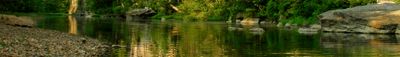
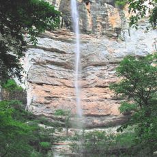
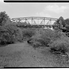
The Buffalo National River flows through the Ozark Mountains with limestone cliffs rising along its banks, alternating between swift rapids and calm pools. The river has never been dammed, allowing it to carve continuously through the landscape and create diverse water conditions that change with the seasons.

The river received official protection in 1972 as America's first national river, marking a turning point in how the country valued wild waterways. This designation came after decades of local conservation efforts and growing recognition that undammed rivers deserved federal safeguards.

The river valley holds meaning for people who value wild, free-flowing waterways that remain largely unchanged by modern development. Visitors come here seeking connection to nature in a landscape where the river still moves on its own terms.

The river can be explored by kayak and canoe, with water level information available to help plan trips safely. The water conditions change throughout the year, so checking current flow rates before your visit helps you choose the right sections for your skill level.

This river was designated as an International Dark Sky Park, meaning the night skies here remain uncommonly free from artificial light pollution. Visitors who spend time here after dark can see far more stars and constellations than in most inhabited regions of the country.

Location: Arkansas

Operator: National Park Service

Website: https://nps.gov/buff

GPS coordinates: 35.98095,-92.81202

Latest update: December 19, 2025 22:48

Photos
Around this place
Dogpatch USA
United States of America

Dogpatch USA

32 km
Hemmed-In-Hollow Falls
United States of America

Hemmed-In-Hollow Falls

45.7 km
United States of America

Buffalo River Trail

53 km
United States of America

Mystic Caverns and Crystal Dome

32.3 km
Rush Historic District
United States of America

Rush Historic District

27.5 km
Big Buffalo Valley Historic District
United States of America

Big Buffalo Valley Historic District

52.2 km
Buffalo River State Park
United States of America

Buffalo River State Park

24.5 km
Newton County Jail
United States of America

Newton County Jail

33.9 km
United States of America

Twelve Oaks

34.4 km
Old Searcy County Jail
United States of America

Old Searcy County Jail

18 km
Parker-Hickman Farm Historic District
United States of America

Parker-Hickman Farm Historic District

38.2 km
Shady Grove Delmar Church and School
United States of America

Shady Grove Delmar Church and School

52.8 km
Henley Hotel
United States of America

Henley Hotel

5.5 km
Bank of Marshall Building
United States of America

Bank of Marshall Building

18.1 km
Little Buffalo River Bridge
United States of America

Little Buffalo River Bridge

37.4 km
Hirst-Mathew Hall
United States of America

Hirst-Mathew Hall

18.1 km
Buffalo River Bridge
United States of America

Buffalo River Bridge

30.7 km
Pea Ridge School Building
United States of America

Pea Ridge School Building

13.6 km
Bates Tourist Court
United States of America

Bates Tourist Court

18 km
Villines Mill
United States of America

Villines Mill

52.8 km
Cold Springs School
United States of America

Cold Springs School

33 km
United States of America

Gould Jones Reservoir

33.7 km
Anthony Luna House
United States of America

Anthony Luna House

18.2 km
Newton County Courthouse
United States of America

Newton County Courthouse

33.9 km
Harp Creek Bridge
United States of America

Harp Creek Bridge

31.4 km
Aggie Workshop
United States of America

Aggie Workshop

18.2 km
Bromley-Mills-Treece House
United States of America

Bromley-Mills-Treece House

18.4 km
Jasper Commercial Historic District
United States of America

Jasper Commercial Historic District

33.9 km
Show the full map
Reviews

Visited this place? Tap the stars to rate it and share your experience / photos with the community! Try now! You can cancel it anytime.

« Buffalo National River - National river and dark sky park in Arkansas, United States » is provided by Around Us (aroundus.com). Images and texts are derived from Wikimedia project under a Creative Commons license. You are allowed to copy, distribute, and modify copies of this page, under the conditions set by the license, as long as this note is clearly visible.

Discover hidden gems everywhere you go!

From secret cafés to breathtaking viewpoints, skip the crowded tourist spots and find places that match your style. Our app makes it easy with voice search, smart filtering, route optimization, and insider tips from travelers worldwide. Download now for the complete mobile experience.

Around Us App Screenshot

A unique approach to discovering new places

Le Figaro

All the places worth exploring

France Info

A tailor-made excursion in just a few clicks

20 Minutes