Black Fork Mountain Wilderness

Log in to your account

AroundUs is a community-driven map of interesting places, built by curious explorers like you. It grows with every review, story, and photo you share.
Connect to save your favorite spots, contribute locations, and create personalized routes.
By continuing, you accept our Terms and Conditions and our Privacy Policy

Black Fork Mountain Wilderness

Add to collection
Map
Suggest a change
Share

Black Fork Mountain Wilderness, Protected wilderness area across Arkansas and Oklahoma, United States.

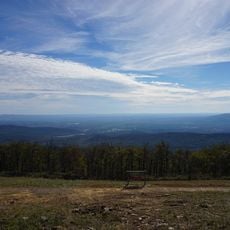
Black Fork Mountain Wilderness is a protected area spanning Arkansas and Oklahoma, defined by towering sandstone cliffs and thick forests of shortleaf pine and oak trees. Elevations reach around 2,400 feet, creating rugged terrain with steep slopes and rocky outcrops throughout the region.

The area received official protection status in 1984, with portions designated within the Ouachita National Forest to preserve the natural landscape. This designation recognized the ecological importance of the region's undisturbed forests and geological features.

The wilderness preserves undisturbed natural landscapes where visitors experience solitude while following traditional outdoor practices without mechanical transportation.

The Arkansas section has a marked trail to the summit, while Oklahoma areas lack maintained paths and require solid outdoor navigation skills. Visitors should prepare for changing conditions and bring extra experience when exploring the less accessible sections.

The terrain contains rare groves of dwarf oak and sugar maple trees found nowhere else nearby. Rocky slopes throughout the wilderness display stone formations that resemble glacial remnants from a distant past.

Location: Arkansas

Location: Oklahoma

GPS coordinates: 34.71560,-94.42690

Latest update: December 12, 2025 07:54

Photos
Around this place
Queen Wilhelmina State Park
United States of America

Queen Wilhelmina State Park

6.3 km
Lake Wister
United States of America

Lake Wister

37.3 km
Peter Conser House
United States of America

Peter Conser House

27.6 km
Lake Wister State Park
United States of America

Lake Wister State Park

38.8 km
Hartford Water Tower
United States of America

Hartford Water Tower

34.7 km
Mountain Fork Bridge
United States of America

Mountain Fork Bridge

21 km
C.E. Foster House
United States of America

C.E. Foster House

5.9 km
Jones Memorial Methodist Church
United States of America

Jones Memorial Methodist Church

34.5 km
Ebenezer Monument
United States of America

Ebenezer Monument

22.3 km
Mena City Hall
United States of America

Mena City Hall

22.6 km
Scott County Courthouse
United States of America

Scott County Courthouse

36.9 km
Janssen Park
United States of America

Janssen Park

22.6 km
Terry House
United States of America

Terry House

41.9 km
LeFlore County Courthouse
United States of America

LeFlore County Courthouse

41.8 km
C.E. Forrester House
United States of America

C.E. Forrester House

37.4 km
Polk County Courthouse
United States of America

Polk County Courthouse

22.4 km
Coop Creek Bridge
United States of America

Coop Creek Bridge

41.9 km
Old Scott County Jail
United States of America

Old Scott County Jail

36.8 km
Judge Benjamin Shaver House
United States of America

Judge Benjamin Shaver House

22.3 km
Bates School
United States of America

Bates School

21.7 km
Sebastian County Road 4G Bridge
United States of America

Sebastian County Road 4G Bridge

30.6 km
Elks Lodge
United States of America

Elks Lodge

22.6 km
Mena Commercial Historic District
United States of America

Mena Commercial Historic District

22.9 km
Hartford Commercial Historic District
United States of America

Hartford Commercial Historic District

34.6 km
Poteau Work Center
United States of America

Poteau Work Center

38.3 km
Poteau Work Center Residence No. 2
United States of America

Poteau Work Center Residence No. 2

38.3 km
Scott Theatre
United States of America

Scott Theatre

36.9 km
Rich Mountain Lookout Tower
United States of America

Rich Mountain Lookout Tower

10.1 km
Show the full map
Reviews

Visited this place? Tap the stars to rate it and share your experience / photos with the community! Try now! You can cancel it anytime.

« Black Fork Mountain Wilderness - Protected wilderness area across Arkansas and Oklahoma, United States » is provided by Around Us (aroundus.com). Images and texts are derived from Wikimedia project under a Creative Commons license. You are allowed to copy, distribute, and modify copies of this page, under the conditions set by the license, as long as this note is clearly visible.

Discover hidden gems everywhere you go!

From secret cafés to breathtaking viewpoints, skip the crowded tourist spots and find places that match your style. Our app makes it easy with voice search, smart filtering, route optimization, and insider tips from travelers worldwide. Download now for the complete mobile experience.

Around Us App Screenshot

A unique approach to discovering new places

Le Figaro

All the places worth exploring

France Info

A tailor-made excursion in just a few clicks

20 Minutes