Enable Location

We need your location to show you interesting places around you

Discover nearby places

Find interesting locations and hidden gems around you

Precise directions

Get accurate directions and distances to places

Your location is never shared with other users. It's only used when you tap the location button.

Lake Wister

Log in to your account

Start exploring — it's free

Trusted by 62,535 travelers worldwide

Continue with Google
Continue with Apple
or

We will send you a code to connect

By continuing, you accept our Terms and Conditions and our Privacy Policy

Check your inbox

We've sent a pincode in your inbox. Please enter the code below.

Lake Wister

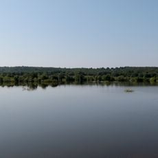
Lake Wister, body of water

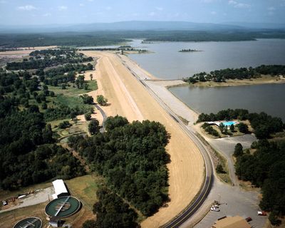
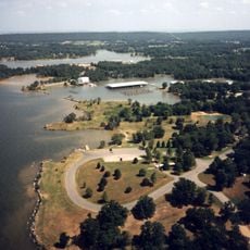
Lake Wister is a large reservoir in southeastern Oklahoma created by damming the Poteau River. The water is bordered by wooded shores and open spaces, providing ample room for fishing, boating, and camping throughout the surrounding area.

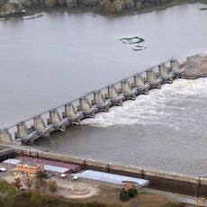
The lake was created many decades ago by building a dam on the Poteau River to control flooding and provide water storage for the region. The dam is managed by the U.S. Army Corps of Engineers and has become a recreational destination for many generations of visitors.

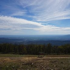
The lake reflects a local tradition of connection to nature that runs deep in this region. People have gathered here for generations to find rest and recreation in a simple, outdoor setting.

The lake is easily reached via US 270 and sits about two miles south of the town of Wister. There are boat ramps, nearby campgrounds with tent and RV sites, and local shops where you can obtain fishing gear and supplies before spending a day on the water.

The water often has a brownish or murky color that sets it apart from other similar lakes in the region. Visitors particularly note the calm mornings with fog lingering over the water, when fishing prospects are often best.

The community of curious travelers

AroundUs brings together thousands of curated places, local tips, and hidden gems, enriched daily by 60,000 contributors worldwide.

Start exploring
Location
GPS coordinates
34.93694,-94.73306
Latest update
February 9, 2026 08:23
Around this place
Spiro Mounds
United States of America

Spiro Mounds

44.3 km
Queen Wilhelmina State Park
United States of America

Queen Wilhelmina State Park

43.5 km
Robert S. Kerr Reservoir
United States of America

Robert S. Kerr Reservoir

47.3 km
Peter Conser House
United States of America

Peter Conser House

11.6 km
Lake Wister State Park
United States of America

Lake Wister State Park

4 km
W. D. Mayo Lock and Dam
United States of America

W. D. Mayo Lock and Dam

45.1 km
James E. Reynolds House
United States of America

James E. Reynolds House

28.7 km
Hartford Water Tower
United States of America

Hartford Water Tower

33.9 km
Sacred Heart Catholic Church and Rectory
United States of America

Sacred Heart Catholic Church and Rectory

52.9 km
C.E. Foster House
United States of America

C.E. Foster House

43.1 km
Jones Memorial Methodist Church
United States of America

Jones Memorial Methodist Church

33.8 km
Greenwood Presbyterian Church
United States of America

Greenwood Presbyterian Church

53.3 km
Trahern's Station
United States of America

Trahern's Station

21.3 km
Old Sebastian County Jail
United States of America

Old Sebastian County Jail

53.3 km
Terry House
United States of America

Terry House

16.1 km
LeFlore County Courthouse
United States of America

LeFlore County Courthouse

16.4 km
Hackett Creek Bridge
United States of America

Hackett Creek Bridge

40.7 km
United States of America

Summerfield School

28.1 km
Kinta High School
United States of America

Kinta High School

49.8 km
Williams School
United States of America

Williams School

30.5 km
Tucker School
United States of America

Tucker School

40.3 km
Skullyville County Jail
United States of America

Skullyville County Jail

26.4 km
Coop Creek Bridge
United States of America

Coop Creek Bridge

47.3 km
Haskell County Courthouse
United States of America

Haskell County Courthouse

47.4 km
Bates School
United States of America

Bates School

32.3 km
Sebastian County Road 4G Bridge
United States of America

Sebastian County Road 4G Bridge

29.3 km
Hartford Commercial Historic District
United States of America

Hartford Commercial Historic District

33.5 km
Rich Mountain Lookout Tower
United States of America

Rich Mountain Lookout Tower

47.1 km
Show the full map
« Lake Wister - body of water » is provided by Around Us (aroundus.com). Images and texts are derived from Wikimedia project under a Creative Commons license. You are allowed to copy, distribute, and modify copies of this page, under the conditions set by the license, as long as this note is clearly visible.

Discover hidden gems everywhere you go!

From secret cafés to breathtaking viewpoints, skip the crowded tourist spots and find places that match your style. Our app makes it easy with voice search, smart filtering, route optimization, and insider tips from travelers worldwide. Download now for the complete mobile experience.

Around Us App Screenshot

A unique approach to discovering new places

Le Figaro

All the places worth exploring

France Info

A tailor-made excursion in just a few clicks

20 Minutes

Around Us
Travel Guide & Maps
Download

Send to your phone

QR Code
1

Open the camera app on your mobile.

2

Point at the QR code with your camera. A notification will appear.

3

Tap the notification to open the link.