Enable Location

We need your location to show you interesting places around you

Discover nearby places

Find interesting locations and hidden gems around you

Precise directions

Get accurate directions and distances to places

Your location is never shared with other users. It's only used when you tap the location button.

Robert S. Kerr Reservoir

Log in to your account

Start exploring — it's free

Trusted by 62,546 travelers worldwide

Continue with Google
Continue with Apple
or

We will send you a code to connect

By continuing, you accept our Terms and Conditions and our Privacy Policy

Check your inbox

We've sent a pincode in your inbox. Please enter the code below.

Robert S. Kerr Reservoir

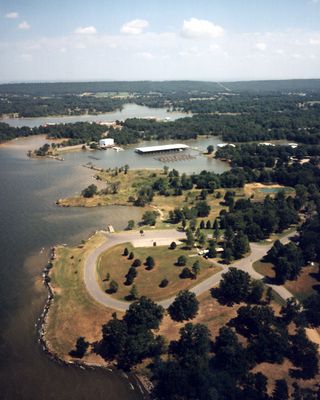
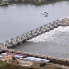
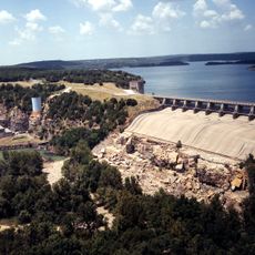
Robert S. Kerr Reservoir, body of water

Robert S. Kerr Reservoir is a large body of water in Oklahoma used mainly for fishing and boating. The area includes several parks along the shores with boat ramps, picnic facilities, and walking paths that give visitors access to the water and surrounding natural areas.

The reservoir was constructed in the 1950s to control flooding and provide water supply for the region. The project helped protect nearby communities from floods and became important for irrigation and the local economy.

The reservoir is named after Robert S. Kerr, an Oklahoma senator whose work shaped water development in the region. Today it serves as a gathering place for locals who fish, boat, and spend time along the shoreline enjoying the natural surroundings.

The reservoir is located near the town of Muskogee, making it easy to find and visit when traveling in the region. Summer offers warm and sunny weather ideal for spending weekends on the water, though the area remains open year-round for outdoor activities.

The area is known for abundant bird and fish life that visitors often spot while walking along the shores or being out on the water. The numerous coves and islands offer chances to explore quieter places where nature and water come together.

The community of curious travelers

AroundUs brings together thousands of curated places, local tips, and hidden gems, enriched daily by 60,000 contributors worldwide.

Start exploring
Location
GPS coordinates
35.35056,-94.85278
Latest update
February 7, 2026 11:00
Around this place
Spiro Mounds
United States of America

Spiro Mounds

26.2 km
Tenkiller Ferry Lake
United States of America

Tenkiller Ferry Lake

36.5 km
Fort Smith National Historic Site
United States of America

Fort Smith National Historic Site

38.5 km
Sequoyah's Cabin
United States of America

Sequoyah's Cabin

25.8 km
Fort Smith Trolley Museum
United States of America

Fort Smith Trolley Museum

38.5 km
Fort Smith National Cemetery
United States of America

Fort Smith National Cemetery

38.7 km
Dwight Presbyterian Mission
United States of America

Dwight Presbyterian Mission

21.9 km
St. Louis–San Francisco 4003
United States of America

St. Louis–San Francisco 4003

38.6 km
Fort Smith Museum of History
United States of America

Fort Smith Museum of History

38.7 km
Birney Safety Streetcar No. 224
United States of America

Birney Safety Streetcar No. 224

38.6 km
W. D. Mayo Lock and Dam
United States of America

W. D. Mayo Lock and Dam

27 km
James E. Reynolds House
United States of America

James E. Reynolds House

38 km
Maumelle Ordnance Works Locomotive 1
United States of America

Maumelle Ordnance Works Locomotive 1

38.5 km
Trahern's Station
United States of America

Trahern's Station

26.1 km
United States Air Force Locomotive No. 1246
United States of America

United States Air Force Locomotive No. 1246

38.6 km
West Garrison Avenue Historic District
United States of America

West Garrison Avenue Historic District

38.8 km
Hines Round Barn
United States of America

Hines Round Barn

12.4 km
United States of America

Summerfield School

21.1 km
Williams School
United States of America

Williams School

34.3 km
Tucker School
United States of America

Tucker School

12.2 km
Skullyville County Jail
United States of America

Skullyville County Jail

23.2 km
First Presbyterian Church
United States of America

First Presbyterian Church

13.3 km
Haskell County Courthouse
United States of America

Haskell County Courthouse

23.3 km
Arkoma School
United States of America

Arkoma School

38.1 km
Judge Franklin Faulkner House
United States of America

Judge Franklin Faulkner House

14.2 km
Sequoyah's Cabin
United States of America

Sequoyah's Cabin

25.8 km
14 Flags Museum
United States of America

14 Flags Museum

13.7 km
Tenkiller Ferry Dam
United States of America

Tenkiller Ferry Dam

31.9 km
Show the full map
« Robert S. Kerr Reservoir - body of water » is provided by Around Us (aroundus.com). Images and texts are derived from Wikimedia project under a Creative Commons license. You are allowed to copy, distribute, and modify copies of this page, under the conditions set by the license, as long as this note is clearly visible.

Discover hidden gems everywhere you go!

From secret cafés to breathtaking viewpoints, skip the crowded tourist spots and find places that match your style. Our app makes it easy with voice search, smart filtering, route optimization, and insider tips from travelers worldwide. Download now for the complete mobile experience.

Around Us App Screenshot

A unique approach to discovering new places

Le Figaro

All the places worth exploring

France Info

A tailor-made excursion in just a few clicks

20 Minutes

Around Us
Travel Guide & Maps
Download

Send to your phone

QR Code
1

Open the camera app on your mobile.

2

Point at the QR code with your camera. A notification will appear.

3

Tap the notification to open the link.