Enable Location

We need your location to show you interesting places around you

Discover nearby places

Find interesting locations and hidden gems around you

Precise directions

Get accurate directions and distances to places

Your location is never shared with other users. It's only used when you tap the location button.

Bigelow Bridge

Log in to your account

Start exploring — it's free

Trusted by 62,830 travelers worldwide

Continue with Google
Continue with Apple
or

We will send you a code to connect

By continuing, you accept our Terms and Conditions and our Privacy Policy

Check your inbox

We've sent a pincode in your inbox. Please enter the code below.

Bigelow Bridge

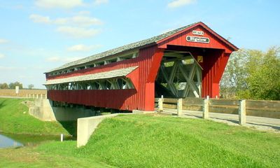
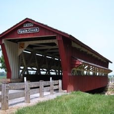
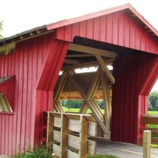
Bigelow Bridge, Covered bridge in Union County, Ohio

Bigelow Bridge is a wooden covered span that crosses Darby Creek using traditional construction methods and wooden siding. It serves as an active connection between the small communities of Irwin and Chuckery in the region.

Built in 1873, the bridge emerged during the era when such structures were essential for connecting rural areas. A renovation in the 1990s added internal steel reinforcement to ensure its continued use and longevity.

The structure played a central role in connecting local communities and their daily routes for generations. Today, its presence reflects how people valued practical engineering solutions in their everyday lives.

The bridge can be reached via Axe Handle Road, located north of State Route 161, making it accessible without difficulty. Since it remains in active use for daily traffic, plan your visit when you prefer lighter vehicle activity.

A marker placed by the Ohio Historical Society at the site draws attention to the bridge's role in the broader Darby Plains region. Visitors often overlook this commemorative sign while passing through, yet it offers context about the landscape's past.

The community of curious travelers

AroundUs brings together thousands of curated places, local tips, and hidden gems, enriched daily by 60,000 contributors worldwide.

Start exploring
Location
GPS coordinates
40.11610,-83.42500
Latest update
December 14, 2025 17:42
Around this place
Muirfield Village
United States of America

Muirfield Village

24.3 km
Big Darby Creek
United States of America

Big Darby Creek

24.2 km
Early Television Museum
United States of America

Early Television Museum

24.2 km
Carl Potter Mound
United States of America

Carl Potter Mound

17.3 km
Ellis Mounds
United States of America

Ellis Mounds

20.1 km
Church of Our Saviour
United States of America

Church of Our Saviour

12.1 km
Farmers National Bank
United States of America

Farmers National Bank

13.4 km
Village Hobby Shop
United States of America

Village Hobby Shop

12.2 km
Hilliard Methodist Episcopal Church
United States of America

Hilliard Methodist Episcopal Church

24.5 km
Elmwood Place
United States of America

Elmwood Place

5.1 km
The Fort
United States of America

The Fort

16.7 km
Jeff Kimball House
United States of America

Jeff Kimball House

12.3 km
John H. Clark House
United States of America

John H. Clark House

12.2 km
Oram Nincehelser House
United States of America

Oram Nincehelser House

12.2 km
Valentine Wilson House
United States of America

Valentine Wilson House

20.5 km
William Culbertson House
United States of America

William Culbertson House

12.1 km
Demand-Gest House
United States of America

Demand-Gest House

12.2 km
Myer House
United States of America

Myer House

23.3 km
Noor Islamic Cultural Center
United States of America

Noor Islamic Cultural Center

24.1 km
Ohio Reformatory for Women
United States of America

Ohio Reformatory for Women

12.1 km
Masonic Temple
United States of America

Masonic Temple

12.2 km
Odd Fellows Hall
United States of America

Odd Fellows Hall

24.4 km
Spain Creek Covered Bridge
United States of America

Spain Creek Covered Bridge

15 km
Dublin City Hall
United States of America

Dublin City Hall

24.4 km
David Marshall House
United States of America

David Marshall House

19.9 km
Pottersburg Covered Bridge
United States of America

Pottersburg Covered Bridge

16.4 km
Company E, 30th Ohio Volunteer Infantry
United States of America

Company E, 30th Ohio Volunteer Infantry

21.9 km
Universalist Church
United States of America

Universalist Church

10.9 km
Show the full map
« Bigelow Bridge - Covered bridge in Union County, Ohio » is provided by Around Us (aroundus.com). Images and texts are derived from Wikimedia project under a Creative Commons license. You are allowed to copy, distribute, and modify copies of this page, under the conditions set by the license, as long as this note is clearly visible.

Discover hidden gems everywhere you go!

From secret cafés to breathtaking viewpoints, skip the crowded tourist spots and find places that match your style. Our app makes it easy with voice search, smart filtering, route optimization, and insider tips from travelers worldwide. Download now for the complete mobile experience.

Around Us App Screenshot

A unique approach to discovering new places

Le Figaro

All the places worth exploring

France Info

A tailor-made excursion in just a few clicks

20 Minutes

Around Us
Travel Guide & Maps
Download

Send to your phone

QR Code
1

Open the camera app on your mobile.

2

Point at the QR code with your camera. A notification will appear.

3

Tap the notification to open the link.