Enable Location

We need your location to show you interesting places around you

Discover nearby places

Find interesting locations and hidden gems around you

Precise directions

Get accurate directions and distances to places

Your location is never shared with other users. It's only used when you tap the location button.

Big Darby Creek

Log in to your account

Start exploring — it's free

Trusted by 62,833 travelers worldwide

Continue with Google
Continue with Apple
or

We will send you a code to connect

By continuing, you accept our Terms and Conditions and our Privacy Policy

Check your inbox

We've sent a pincode in your inbox. Please enter the code below.

Big Darby Creek

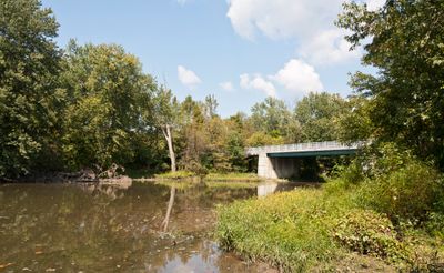
Big Darby Creek, Brook in Logan County, Ohio, United States.

Big Darby Creek is a waterway that flows for about 84 miles through Union, Madison, and Franklin counties in central Ohio. The creek winds through various landscapes before eventually joining the Scioto River at its endpoint.

The creek received state protection in 1984 when Ohio designated it as a Scenic River, followed by national recognition in the Wild and Scenic Rivers System in 1994. These designations highlight its importance for environmental conservation.

Researchers documented 72 different fish species and 40 freshwater mussel species in the creek during extensive surveys between 1984 and 1992.

The creek is best explored through the adjoining Battelle Darby Creek Metro Park, which provides access points and trails along the waterway. Visitors should be prepared for varying water levels and wear appropriate footwear when venturing into surrounding areas.

The waterway supports a remarkably diverse ecosystem with numerous fish and freshwater mussel species, making it an important location for studying freshwater organisms. This biological richness makes it valuable for both nature enthusiasts and researchers.

The community of curious travelers

AroundUs brings together thousands of curated places, local tips, and hidden gems, enriched daily by 60,000 contributors worldwide.

Start exploring
Location
GPS coordinates
39.95136,-83.24058
Latest update
December 10, 2025 16:23
Around this place
Field of Corn (with Osage Orange Trees)
United States of America

Field of Corn (with Osage Orange Trees)

17.9 km
Hollywood Casino Columbus
United States of America

Hollywood Casino Columbus

11.4 km
Scioto Country Club
United States of America

Scioto Country Club

15.2 km
Early Television Museum
United States of America

Early Television Museum

11.5 km
United States of America

WBNS TV Tower

18.6 km
Madison Lake State Park
United States of America

Madison Lake State Park

14.6 km
United States of America

Battelle Darby Creek Metropolitan Park

8.8 km
The Tree Bar
United States of America

The Tree Bar

18.5 km
Farmers National Bank
United States of America

Farmers National Bank

17.5 km
Swetland House
United States of America

Swetland House

18.7 km
A.G. Grant Homestead
United States of America

A.G. Grant Homestead

15.5 km
Hilliard Methodist Episcopal Church
United States of America

Hilliard Methodist Episcopal Church

11.6 km
Gantz Homestead
United States of America

Gantz Homestead

16.3 km
Samuel Davis House
United States of America

Samuel Davis House

15.7 km
Anson Davis House and Springhouse
United States of America

Anson Davis House and Springhouse

16.2 km
Pataskala United Methodist Church
United States of America

Pataskala United Methodist Church

18.7 km
Myer House
United States of America

Myer House

16 km
Pataskala Presbyterian Church
United States of America

Pataskala Presbyterian Church

18.7 km
Dr. James Merryman House
United States of America

Dr. James Merryman House

11.6 km
Saint Brendan the Navigator Church
United States of America

Saint Brendan the Navigator Church

16.1 km
Noor Islamic Cultural Center
United States of America

Noor Islamic Cultural Center

14.9 km
Odd Fellows Hall
United States of America

Odd Fellows Hall

11.6 km
AMC Lennox Town Center 24
United States of America

AMC Lennox Town Center 24

18.7 km
Upper Arlington Historic District
United States of America

Upper Arlington Historic District

15.9 km
David Marshall House
United States of America

David Marshall House

17.8 km
The National Road
United States of America

The National Road

15.3 km
Camp Chase
United States of America

Camp Chase

14.1 km
Ohio Craft Museum
United States of America

Ohio Craft Museum

16.7 km
Show the full map
« Big Darby Creek - Brook in Logan County, Ohio, United States » is provided by Around Us (aroundus.com). Images and texts are derived from Wikimedia project under a Creative Commons license. You are allowed to copy, distribute, and modify copies of this page, under the conditions set by the license, as long as this note is clearly visible.

Discover hidden gems everywhere you go!

From secret cafés to breathtaking viewpoints, skip the crowded tourist spots and find places that match your style. Our app makes it easy with voice search, smart filtering, route optimization, and insider tips from travelers worldwide. Download now for the complete mobile experience.

Around Us App Screenshot

A unique approach to discovering new places

Le Figaro

All the places worth exploring

France Info

A tailor-made excursion in just a few clicks

20 Minutes

Around Us
Travel Guide & Maps
Download

Send to your phone

QR Code
1

Open the camera app on your mobile.

2

Point at the QR code with your camera. A notification will appear.

3

Tap the notification to open the link.