Boonton Formation

Log in to your account

AroundUs is a community-driven map of interesting places, built by curious explorers like you. It grows with every review, story, and photo you share.
Connect to save your favorite spots, contribute locations, and create personalized routes.
Continue with Google
Continue with Apple
Continue with X
Continue with Facebook
Continue with email
By continuing, you accept our Terms and Conditions and our Privacy Policy
Create an account
Add to collection
Map
Suggest a change
Share

Boonton Formation, Geological formation in Morris County, New Jersey, United States.

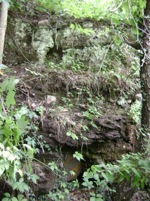
The Boonton Formation is a geological layer in Morris County composed of reddish-brown sandstone alternating with red, gray, purple, and black siltstone. The rock layers stack together to reveal how this region's geology developed over time.

This rock layer formed roughly 190 to 197 million years ago during an early phase of the dinosaur age. It was named after the nearby town of Boonton and marks an important period in the geological development of this region.

The formation preserves numerous fossils, including fish specimens like Semiontus elegans and Diplurus longicaudatus, along with reptile tracks and plant remains.

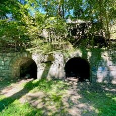
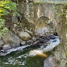
Visitors can observe these rock layers at exposed cuts in the area, especially along road cuts and quarry faces. For detailed scientific data and water samples, the USGS maintains monitoring stations nearby.

Fossils of fish and reptiles are commonly found in this formation, showing that this area was once covered by water. These remains offer rare glimpses into the animal life of that distant geological past.

Location: New Jersey

Made from material: sandstone

GPS coordinates: 40.90000,-74.40000

Latest update: December 14, 2025 17:40

Photos
Around this place
Tripod Rock
United States of America

Tripod Rock

5.8 km
Troy Meadows
United States of America

Troy Meadows

6.3 km
Grimes Homestead
United States of America

Grimes Homestead

4.2 km
Boonton Ironworks
United States of America

Boonton Ironworks

1.3 km
United States of America

Boonton Gorge

1.8 km
Arch Bridge from the Boonton Ironworks
United States of America

Arch Bridge from the Boonton Ironworks

1.5 km
Boonton Historic District
United States of America

Boonton Historic District

1.1 km
Henry Doremus House
United States of America

Henry Doremus House

4.4 km
Parsonage of the Montville Reformed Dutch Church
United States of America

Parsonage of the Montville Reformed Dutch Church

2.9 km
Boonton Historical Society and Museum
United States of America

Boonton Historical Society and Museum

620 m
Van Duyne-Jacobus House
United States of America

Van Duyne-Jacobus House

3.3 km
Stephen Condit House
United States of America

Stephen Condit House

4.2 km
Boonton Public Library
United States of America

Boonton Public Library

1.1 km
Miller-Kingsland House
United States of America

Miller-Kingsland House

1.1 km
Simon Van Duyne House
United States of America

Simon Van Duyne House

6.4 km
Bowers-Livingston-Osborn House
United States of America

Bowers-Livingston-Osborn House

4.5 km
Martin Van Duyne House
United States of America

Martin Van Duyne House

3.1 km
James Dixon Farm
United States of America

James Dixon Farm

4.8 km
Davenport-Demarest House
United States of America

Davenport-Demarest House

2.9 km
James Van Duyne Farmhouse
United States of America

James Van Duyne Farmhouse

5.2 km
Rockaway Valley Methodist Church
United States of America

Rockaway Valley Methodist Church

4.4 km
Montville Schoolhouse
United States of America

Montville Schoolhouse

2.2 km
Johannes Parlaman House
United States of America

Johannes Parlaman House

1.6 km
Nicholas Vreeland Outkitchen
United States of America

Nicholas Vreeland Outkitchen

6.2 km
Effingham Low House
United States of America

Effingham Low House

5.8 km
Bowlsby-Degelleke House
United States of America

Bowlsby-Degelleke House

3.5 km
Boonton Falls
United States of America

Boonton Falls

1.7 km
Mountain Lakes Historic District
United States of America

Mountain Lakes Historic District

3.4 km
Show the full map
Reviews

Visited this place? Tap the stars to rate it and share your experience / photos with the community! Try now! You can cancel it anytime.

« Boonton Formation - Geological formation in Morris County, New Jersey, United States » is provided by Around Us (aroundus.com). Images and texts are derived from Wikimedia project under a Creative Commons license. You are allowed to copy, distribute, and modify copies of this page, under the conditions set by the license, as long as this note is clearly visible.

Discover hidden gems everywhere you go!

From secret cafés to breathtaking viewpoints, skip the crowded tourist spots and find places that match your style. Our app makes it easy with voice search, smart filtering, route optimization, and insider tips from travelers worldwide. Download now for the complete mobile experience.

Around Us App Screenshot

A unique approach to discovering new places

Le Figaro

All the places worth exploring

France Info

A tailor-made excursion in just a few clicks

20 Minutes