Chest opened
+${chestReward.xp} XP
Explorer
NOUVEAU ×${chestReward.collectible.quantity}
tapez pour fermer
Chest locked

Open chests in the app

Around Us is built for your phone — chests unlock when you walk, explore and capture nearby places.

Enable Location

We need your location to show you interesting places around you

Discover nearby places

Find interesting locations and hidden gems around you

Precise directions

Get accurate directions and distances to places

Your location is never shared with other users. It's only used when you tap the location button.

Log in to your account

Start exploring — it's free

Trusted by 72,893 travelers worldwide

Continue with Google
Continue with Apple
or

We will send you a code to connect

By continuing, you accept our Terms and Conditions and our Privacy Policy

Check your inbox

We've sent a pincode in your inbox. Please enter the code below.

Bustleton
Discussion Reviews Photo
10.7k Popularity

Bustleton, Residential neighborhood in Northeast Philadelphia, United States

Bustleton is a residential neighborhood in Northeast Philadelphia, bordered by Roosevelt Boulevard, the city limit, Red Lion Road, and Pennypack Park to the south. The area has a range of local shops, health services, and small businesses spread along its main roads.

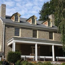
The area grew around Bustleton Tavern, which served as a trading stop for farmers before the American Revolution. This early commercial role shaped the settlement that later developed into the neighborhood seen today.

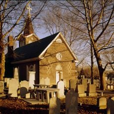
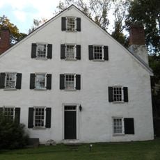
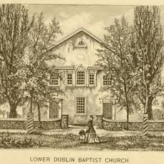
The Lower Dublin Baptist Church is one of the oldest congregations in the United States and still stands in this neighborhood today. Its cemetery holds graves of early settlers, making it a place where some local families come to trace their roots.

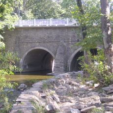
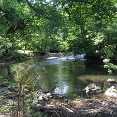
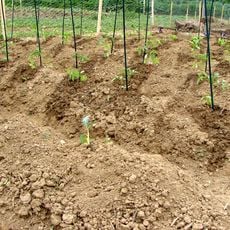
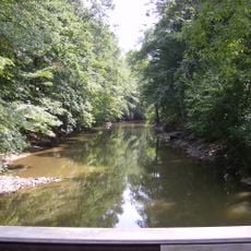
The neighborhood is easiest to get around by car, with Roosevelt Boulevard serving as the main entry point from other parts of the city. Pennypack Park runs along the southern edge and offers a good starting point for walking or spending time outdoors.

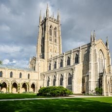
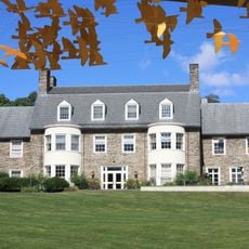
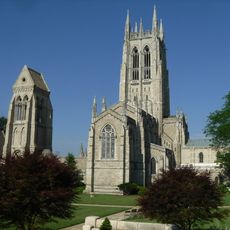
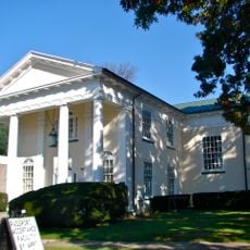
The Episcopal Church of Saint Luke was designed by Richard Upjohn, the same architect behind Trinity Church in Manhattan, and consecrated in 1861. Finding one of his buildings in a residential neighborhood rather than a city center makes it a detail worth noticing on a walk through the area.

The community of curious travelers

AroundUs brings together thousands of curated places, local tips, and hidden gems, enriched daily by 60,000 contributors worldwide.

Start exploring
Location
GPS coordinates
40.09910,-75.04360
Latest update
March 5, 2026 21:06
Around this place
Bryn Athyn Cathedral
United States of America

Bryn Athyn Cathedral

4.3 km
Frankford Avenue Bridge
United States of America

Frankford Avenue Bridge

6.5 km
Pennypack Park
United States of America

Pennypack Park

4.9 km
Glencairn Museum
United States of America

Glencairn Museum

4.5 km
Insectarium
United States of America

Insectarium

6.5 km
Cairnwood
United States of America

Cairnwood

4.8 km
Growden Mansion
United States of America

Growden Mansion

6.4 km
Ryerss Mansion
United States of America

Ryerss Mansion

5.2 km
Poquessing Creek
United States of America

Poquessing Creek

6.6 km
Benjamin Rush State Park
United States of America

Benjamin Rush State Park

6.1 km
Old Trinity Church
United States of America

Old Trinity Church

6.2 km
Fox Chase Farm
United States of America

Fox Chase Farm

2.9 km
Abington Art Center
United States of America

Abington Art Center

6.3 km
Lorimer Park
United States of America

Lorimer Park

2.6 km
Joseph H. Brown Elementary School
United States of America

Joseph H. Brown Elementary School

6.4 km
Greenbelt Knoll
United States of America

Greenbelt Knoll

5.1 km
Bryn Athyn Historic District
United States of America

Bryn Athyn Historic District

4.3 km
Rowland House
United States of America

Rowland House

6.3 km
Cedar Grove Christian Academy
United States of America

Cedar Grove Christian Academy

6.9 km
Pennepek Baptist Church
United States of America

Pennepek Baptist Church

2.1 km
Kennedy Crossan School
United States of America

Kennedy Crossan School

5.3 km
Holme Avenue Bridge
United States of America

Holme Avenue Bridge

5.1 km
Fetter's Mill Village Historic District
United States of America

Fetter's Mill Village Historic District

4.4 km
Mechanicsville School
United States of America

Mechanicsville School

6.6 km
Knowlton Mansion
United States of America

Knowlton Mansion

3.9 km
Rockledge Model Railroad Museum presented by Gatsme Model RR Club
United States of America

Rockledge Model Railroad Museum presented by Gatsme Model RR Club

4.2 km
Jenkins' Town Lyceum Building
United States of America

Jenkins' Town Lyceum Building

7 km
George K. Heller School
United States of America

George K. Heller School

6.2 km
Show the full map
Reviews
Share your experience

No review yet

Discussions
Start a discussion...

No discussion yet

« Bustleton - Residential neighborhood in Northeast Philadelphia, United States » is provided by Around Us (aroundus.com). Images and texts are derived from Wikimedia project under a Creative Commons license. You are allowed to copy, distribute, and modify copies of this page, under the conditions set by the license, as long as this note is clearly visible.

Discover hidden gems everywhere you go!

From secret cafés to breathtaking viewpoints, skip the crowded tourist spots and find places that match your style. Our app makes it easy with voice search, smart filtering, route optimization, and insider tips from travelers worldwide. Download now for the complete mobile experience.

Around Us App Screenshot

A unique approach to discovering new places

Le Figaro

All the places worth exploring

France Info

A tailor-made excursion in just a few clicks

20 Minutes

Around Us
Travel Guide & Maps
Download

Send to your phone

QR Code
1

Open the camera app on your mobile.

2

Point at the QR code with your camera. A notification will appear.

3

Tap the notification to open the link.