Enable Location

We need your location to show you interesting places around you

Discover nearby places

Find interesting locations and hidden gems around you

Precise directions

Get accurate directions and distances to places

Your location is never shared with other users. It's only used when you tap the location button.

Cowans Ford Hydroelectric Station

Log in to your account

Start exploring — it's free

Trusted by 65,099 travelers worldwide

Continue with Google
Continue with Apple
or

We will send you a code to connect

By continuing, you accept our Terms and Conditions and our Privacy Policy

Check your inbox

We've sent a pincode in your inbox. Please enter the code below.

Cowans Ford Hydroelectric Station
Discussion Reviews 1 Photos
4.4k Popularity

Cowans Ford Hydroelectric Station, Hydroelectric power station near Huntersville, North Carolina.

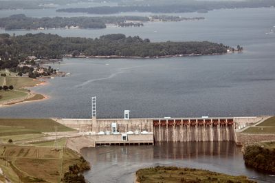
Cowans Ford Hydroelectric Station is a dam and power plant on Lake Norman, near Huntersville in North Carolina. The facility uses four Kaplan turbines to generate electricity from the water held back by the dam.

Duke Energy built the station between 1959 and 1963 by damming the Catawba River, which flooded the valley and formed Lake Norman. The project was part of a broader effort to meet the growing energy needs of North Carolina at the time.

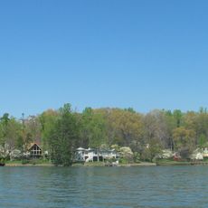
The dam that feeds the station created Lake Norman, which people across the region use today for fishing, boating, and swimming. The lake has become a central part of everyday life in the communities around it, far beyond its original purpose.

The area around the dam includes publicly accessible shoreline paths along Lake Norman that can be walked without prior arrangement. The operational areas of the plant are off-limits, so visitors are best off keeping to the lakeside trails and viewpoints.

The plant is designed to operate as a peaking facility, meaning it ramps up or slows down based on electricity demand, sometimes within hours. This can cause the water level of the lake to rise or fall noticeably in a single day, which visitors near the shoreline may actually observe.

The community of curious travelers

AroundUs brings together thousands of curated places, local tips, and hidden gems, enriched daily by 60,000 contributors worldwide.

Start exploring
Location
Length
2,563 m
GPS coordinates
35.43490,-80.95840
Latest update
March 3, 2026 08:10
Around this place
Lake Norman
United States of America

Lake Norman

5.9 km
United States of America

Mountain Island Lake

8.1 km
Richardson Stadium
United States of America

Richardson Stadium

12.7 km
Hoyle Historic Homestead
United States of America

Hoyle Historic Homestead

20.3 km
Beaver Dam Plantation House
United States of America

Beaver Dam Plantation House

13.5 km
Latta Place Historic Site
United States of America

Latta Place Historic Site

9.5 km
Mooresville Mill Village Historic District
United States of America

Mooresville Mill Village Historic District

20.3 km
St. Joseph's Catholic Church
United States of America

St. Joseph's Catholic Church

11.6 km
Ingleside
United States of America

Ingleside

8.4 km
Johnson-Neel House
United States of America

Johnson-Neel House

19.1 km
Centre Presbyterian Church, Session House and Cemeteries
United States of America

Centre Presbyterian Church, Session House and Cemeteries

16.1 km
Andrew Carpenter House
United States of America

Andrew Carpenter House

9.9 km
Eumenean Hall
United States of America

Eumenean Hall

12.4 km
Downtown Mount Holly Historic District
United States of America

Downtown Mount Holly Historic District

16.1 km
Philanthropic Hall, Davidson College
United States of America

Philanthropic Hall, Davidson College

12.4 km
Cedar Grove
United States of America

Cedar Grove

7.1 km
South Broad Street Row
United States of America

South Broad Street Row

20.7 km
United States of America

Ramah Presbyterian Church and Cemetery

14.1 km
Coddle Creek Associate Reformed Presbyterian Church, Session House and Cemetery
United States of America

Coddle Creek Associate Reformed Presbyterian Church, Session House and Cemetery

19.2 km
Eli Hoyle House
United States of America

Eli Hoyle House

20.5 km
Croft Historic District
United States of America

Croft Historic District

15.7 km
Albert McCoy Farm
United States of America

Albert McCoy Farm

10 km
Davidson Historic District
United States of America

Davidson Historic District

12.9 km
George Houston House
United States of America

George Houston House

14.7 km
Edward M. Rozzell House
United States of America

Edward M. Rozzell House

11 km
Chairman Blake House
United States of America

Chairman Blake House

12.2 km
Samuel J. McElroy House
United States of America

Samuel J. McElroy House

8.9 km
John M. Belk Arena
United States of America

John M. Belk Arena

12.9 km
Show the full map
Reviews
Share your experience

No review yet

Discussions
Start a discussion...

No discussion yet

« Cowans Ford Hydroelectric Station - Hydroelectric power station near Huntersville, North Carolina » is provided by Around Us (aroundus.com). Images and texts are derived from Wikimedia project under a Creative Commons license. You are allowed to copy, distribute, and modify copies of this page, under the conditions set by the license, as long as this note is clearly visible.

Discover hidden gems everywhere you go!

From secret cafés to breathtaking viewpoints, skip the crowded tourist spots and find places that match your style. Our app makes it easy with voice search, smart filtering, route optimization, and insider tips from travelers worldwide. Download now for the complete mobile experience.

Around Us App Screenshot

A unique approach to discovering new places

Le Figaro

All the places worth exploring

France Info

A tailor-made excursion in just a few clicks

20 Minutes

Around Us
Travel Guide & Maps
Download

Send to your phone

QR Code
1

Open the camera app on your mobile.

2

Point at the QR code with your camera. A notification will appear.

3

Tap the notification to open the link.