Enable Location

We need your location to show you interesting places around you

Discover nearby places

Find interesting locations and hidden gems around you

Precise directions

Get accurate directions and distances to places

Your location is never shared with other users. It's only used when you tap the location button.

Criel Mound

Log in to your account

Start exploring — it's free

Trusted by 62,258 travelers worldwide

Continue with Google
Continue with Apple
or

We will send you a code to connect

By continuing, you accept our Terms and Conditions and our Privacy Policy

Check your inbox

We've sent a pincode in your inbox. Please enter the code below.

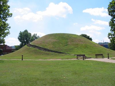
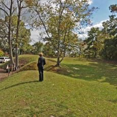
Criel Mound, Prehistoric burial mound in South Charleston, United States

Criel Mound is a conical earthwork located in the center of Staunton Park in South Charleston, measuring 140 feet across and standing 25 feet tall at its peak. The structure demonstrates ancient construction methods and remains a protected example of Native American building practices from prehistoric times.

The mound was constructed between 250 and 150 BC as part of a larger complex of about 50 earthworks stretching from Charleston to Institute. These works reveal how the region was settled and organized by the people who lived across this landscape over many generations.

The mound was named after an early settler and now sits within a park where visitors can see its distinctive shape and scale as a focal point. It bridges the indigenous past with the modern city landscape, standing as a reminder of the people who inhabited this region long before current settlement.

The site sits along MacCorkle Avenue and is easily accessible from the street for viewing at any time. Visitors can walk around the mound and explore the park grounds to see the structure from different angles and understand its setting within the urban landscape.

In the late 1800s, residents dramatically altered the mound by constructing a horse racing track around its edge and flattening its summit to create a judge's platform. These changes reveal how the site served different community purposes before it was eventually protected as a historic place.

The community of curious travelers

AroundUs brings together thousands of curated places, local tips, and hidden gems, enriched daily by 60,000 contributors worldwide.

Start exploring
Location
GPS coordinates
38.36861,-81.69667
Latest update
December 8, 2025 19:52
Around this place
Charleston Municipal Auditorium
United States of America

Charleston Municipal Auditorium

5.3 km
Downtown Charleston Historic District
United States of America

Downtown Charleston Historic District

5.8 km
Sunrise
United States of America

Sunrise

5.5 km
Daniel Boone Hotel
United States of America

Daniel Boone Hotel

5.9 km
Kanawha County Courthouse
United States of America

Kanawha County Courthouse

5.4 km
Charleston City Hall
United States of America

Charleston City Hall

5.4 km
Edgewood Historic District
United States of America

Edgewood Historic District

4.5 km
Canty House
United States of America

Canty House

6 km
Plaza Theatre
United States of America

Plaza Theatre

5.7 km
Charleston Railroad Bridge‎
United States of America

Charleston Railroad Bridge‎

3.1 km
Fort Scammon
United States of America

Fort Scammon

4 km
Woodrums' Building
United States of America

Woodrums' Building

5.6 km
Cox-Parks House
United States of America

Cox-Parks House

5.1 km
Sterrett Brothers' Dry Goods Store
United States of America

Sterrett Brothers' Dry Goods Store

5.7 km
Luna Park Historic District
United States of America

Luna Park Historic District

3.9 km
Breezemont
United States of America

Breezemont

5.2 km
Littlepage Stone Mansion
United States of America

Littlepage Stone Mansion

2.8 km
Loewenstein and Sons Hardware Building
United States of America

Loewenstein and Sons Hardware Building

5.8 km
Bird Haven
United States of America

Bird Haven

5.9 km
Barnes-Wellford House
United States of America

Barnes-Wellford House

5.9 km
Cox-Morton House
United States of America

Cox-Morton House

5.1 km
Laidley-Summers-Quarrier House
United States of America

Laidley-Summers-Quarrier House

4 km
Thomas-McJunkin-Love House
United States of America

Thomas-McJunkin-Love House

5.9 km
Danner-Fletcher House
United States of America

Danner-Fletcher House

5 km
Crawford-Gardner House
United States of America

Crawford-Gardner House

5.4 km
McAndrews-Gallaher House
United States of America

McAndrews-Gallaher House

4.9 km
Shoney's Big Boy Museum
United States of America

Shoney's Big Boy Museum

2.7 km
Grosscup Road Historic District
United States of America

Grosscup Road Historic District

5.9 km
Show the full map
« Criel Mound - Prehistoric burial mound in South Charleston, United States » is provided by Around Us (aroundus.com). Images and texts are derived from Wikimedia project under a Creative Commons license. You are allowed to copy, distribute, and modify copies of this page, under the conditions set by the license, as long as this note is clearly visible.

Discover hidden gems everywhere you go!

From secret cafés to breathtaking viewpoints, skip the crowded tourist spots and find places that match your style. Our app makes it easy with voice search, smart filtering, route optimization, and insider tips from travelers worldwide. Download now for the complete mobile experience.

Around Us App Screenshot

A unique approach to discovering new places

Le Figaro

All the places worth exploring

France Info

A tailor-made excursion in just a few clicks

20 Minutes

Around Us
Travel Guide & Maps
Download

Send to your phone

QR Code
1

Open the camera app on your mobile.

2

Point at the QR code with your camera. A notification will appear.

3

Tap the notification to open the link.