Enable Location

We need your location to show you interesting places around you

Discover nearby places

Find interesting locations and hidden gems around you

Precise directions

Get accurate directions and distances to places

Your location is never shared with other users. It's only used when you tap the location button.

Cross Mountain

Log in to your account

Start exploring — it's free

Trusted by 62,526 travelers worldwide

Continue with Google
Continue with Apple
or

We will send you a code to connect

By continuing, you accept our Terms and Conditions and our Privacy Policy

Check your inbox

We've sent a pincode in your inbox. Please enter the code below.

Cross Mountain

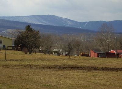
Cross Mountain, Mountain summit in Franklin County, Pennsylvania, USA

Cross Mountain rises to 2,062 feet (629 meters) in the Ridge-and-Valley section of the Appalachians and displays steep slopes with quartzite rock formations. The geology shapes the peak's appearance and makes it a distinctive landform in Franklin County.

The peak once hosted a military microwave relay station with a 103-foot tower called Cannonball Site 2. The facility was deactivated in 1977 and no longer operates today.

The mountain draws hikers and climbers from the surrounding region who regularly visit to experience its natural terrain and rock formations. It serves as a gathering place for outdoor enthusiasts exploring the Appalachian landscape.

Visitors should check weather forecasts and bring sturdy gear, as the summit experiences strong winds and significant temperature swings. Good footwear and water are important, particularly on windy or cool days.

The peak includes a geological formation called the Punchbowl, created by weathered Ordovician shales that form an amphitheater-like structure. This distinctive rock formation is a rare geological feature in the Appalachian region.

The community of curious travelers

AroundUs brings together thousands of curated places, local tips, and hidden gems, enriched daily by 60,000 contributors worldwide.

Start exploring
Location
GPS coordinates
39.72848,-77.99171
Latest update
December 12, 2025 17:42
Around this place
Fort Frederick
United States of America

Fort Frederick

13.5 km
Buchanan's Birthplace State Park
United States of America

Buchanan's Birthplace State Park

16.2 km
Lane House
United States of America

Lane House

13.4 km
Rock Hill Farm
United States of America

Rock Hill Farm

10.8 km
Martin's Mill Covered Bridge
United States of America

Martin's Mill Covered Bridge

18.9 km
Mansfield
United States of America

Mansfield

13.2 km
Wilson's Bridge
United States of America

Wilson's Bridge

14.6 km
Mercersburg Historic District
United States of America

Mercersburg Historic District

13.3 km
Millmont Farm
United States of America

Millmont Farm

13.2 km
Hays Bridge Historic District
United States of America

Hays Bridge Historic District

13.5 km
Edward Colston House
United States of America

Edward Colston House

16.5 km
Plumb Grove
United States of America

Plumb Grove

17.4 km
Harlan Spring Historic District
United States of America

Harlan Spring Historic District

20.1 km
Church Hill Farm
United States of America

Church Hill Farm

17.1 km
Angle Farm
United States of America

Angle Farm

12.6 km
Yeakle's Mill Bridge
United States of America

Yeakle's Mill Bridge

3.9 km
Spring Grove Farm and Distillery
United States of America

Spring Grove Farm and Distillery

20.2 km
Hedgesville Historic District
United States of America

Hedgesville Historic District

19.5 km
Findlay Farm
United States of America

Findlay Farm

15.7 km
Spring Mills Historic District
United States of America

Spring Mills Historic District

19 km
Charles Downs II House
United States of America

Charles Downs II House

19.4 km
Rufus Wilson Complex
United States of America

Rufus Wilson Complex

14.4 km
Teter Myers French House
United States of America

Teter Myers French House

18.2 km
McCoy-Shoemaker Farm
United States of America

McCoy-Shoemaker Farm

16.5 km
Hedges-Robinson-Myers House
United States of America

Hedges-Robinson-Myers House

19.1 km
Clary's Mountain Historic District
United States of America

Clary's Mountain Historic District

19.1 km
Salisbury Street Bridge
United States of America

Salisbury Street Bridge

20.2 km
Hancock Bridge
United States of America

Hancock Bridge

17.1 km
Show the full map
« Cross Mountain - Mountain summit in Franklin County, Pennsylvania, USA » is provided by Around Us (aroundus.com). Images and texts are derived from Wikimedia project under a Creative Commons license. You are allowed to copy, distribute, and modify copies of this page, under the conditions set by the license, as long as this note is clearly visible.

Discover hidden gems everywhere you go!

From secret cafés to breathtaking viewpoints, skip the crowded tourist spots and find places that match your style. Our app makes it easy with voice search, smart filtering, route optimization, and insider tips from travelers worldwide. Download now for the complete mobile experience.

Around Us App Screenshot

A unique approach to discovering new places

Le Figaro

All the places worth exploring

France Info

A tailor-made excursion in just a few clicks

20 Minutes

Around Us
Travel Guide & Maps
Download

Send to your phone

QR Code
1

Open the camera app on your mobile.

2

Point at the QR code with your camera. A notification will appear.

3

Tap the notification to open the link.