·

Enable Location

We need your location to show you interesting places around you

Discover nearby places

Find interesting locations and hidden gems around you

Precise directions

Get accurate directions and distances to places

Your location is never shared with other users. It's only used when you tap the location button.

Des Plaines River Trail

Log in to your account

Start exploring — it's free

Trusted by 62,658 travelers worldwide

Continue with Google
Continue with Apple
or

We will send you a code to connect

By continuing, you accept our Terms and Conditions and our Privacy Policy

Check your inbox

We've sent a pincode in your inbox. Please enter the code below.

Des Plaines River Trail

Des Plaines River Trail, recreational trail area through northeastern Illinois
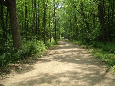
The Des Plaines River Trail follows the Des Plaines River through Illinois for more than 28 miles, passing through forest preserves, woods, and parks. The mostly unpaved path is flat and accessible for walkers and bikers, leading through floodplain forests, oak woodlands, and open fields.

The Des Plaines River has shaped regional communities for hundreds of years, serving people for fishing, transportation, and recreation. Old mills and small bridges along the trail mark past uses of the land and waterway by earlier generations.

The trail serves as a daily connection for residents who walk or bike directly from their neighborhoods into green spaces. This everyday use by local people shapes the path as an open, inviting place where the community spends time outdoors.

The trail is open year-round from sunrise to sunset and can be accessed from multiple entry points including Sunset Bridge Meadow, Evans Field, and Schiller Woods, which offer parking. Stay on the designated path, keep dogs leashed, and clean up after them to ensure a safe and pleasant experience for all visitors.

The trail shows signs of beavers living along the water, with felled trees marking their activity as they search for food. In spring you will find wildflowers and migrating birds filling the forest with song, while in fall squirrels and other animals busily gather nuts for winter.

The community of curious travelers

AroundUs brings together thousands of curated places, local tips, and hidden gems, enriched daily by 60,000 contributors worldwide.

Start exploring
GPS coordinates
42.03167,-87.87450
Latest update
February 7, 2026 11:01
Around this place
Allstate Arena
United States of America

Allstate Arena

3.1 km
Leaning Tower of Niles
United States of America

Leaning Tower of Niles

7.8 km
Rosemont Theatre
United States of America

Rosemont Theatre

6.2 km
Illinois Holocaust Museum and Education Center
United States of America

Illinois Holocaust Museum and Education Center

9.8 km
Chicago Illinois Temple
United States of America

Chicago Illinois Temple

6.3 km
Pickwick Theatre
United States of America

Pickwick Theatre

4.4 km
Des Plaines Methodist Camp Ground
United States of America

Des Plaines Methodist Camp Ground

1.2 km
Noble-Seymour-Crippen House
United States of America

Noble-Seymour-Crippen House

8.4 km
Kohl Children's Museum
United States of America

Kohl Children's Museum

8 km
Kennicott Grove
United States of America

Kennicott Grove

6.2 km
St. Martha Catholic Church
United States of America

St. Martha Catholic Church

7.8 km
Turzak House
United States of America

Turzak House

5.6 km
Wingert House
United States of America

Wingert House

6 km
Katyń Monument in Niles
United States of America

Katyń Monument in Niles

7.2 km
Passionist Fathers Monastery
United States of America

Passionist Fathers Monastery

7.5 km
Eisenhower Public Library District
United States of America

Eisenhower Public Library District

9.2 km
Park Ridge Youth Campus
United States of America

Park Ridge Youth Campus

4 km
Skokie Public Library
United States of America

Skokie Public Library

9.7 km
Statue of Abraham Lincoln
United States of America

Statue of Abraham Lincoln

6.7 km
Harrer Building
United States of America

Harrer Building

10 km
Edison Park
United States of America

Edison Park

5.6 km
Rainbow Falls
United States of America

Rainbow Falls

10.4 km
First Congregational Church
United States of America

First Congregational Church

1.6 km
Hey Nonny
United States of America

Hey Nonny

10.7 km
Herbert A. Dilg House
United States of America

Herbert A. Dilg House

7.5 km
Niles-Maine District Library
United States of America

Niles-Maine District Library

6.1 km
Edgebrook Branch
United States of America

Edgebrook Branch

10.1 km
Morton Grove Public Library
United States of America

Morton Grove Public Library

7.8 km
Show the full map
« Des Plaines River Trail - recreational trail area through northeastern Illinois » is provided by Around Us (aroundus.com). Images and texts are derived from Wikimedia project under a Creative Commons license. You are allowed to copy, distribute, and modify copies of this page, under the conditions set by the license, as long as this note is clearly visible.

Discover hidden gems everywhere you go!

From secret cafés to breathtaking viewpoints, skip the crowded tourist spots and find places that match your style. Our app makes it easy with voice search, smart filtering, route optimization, and insider tips from travelers worldwide. Download now for the complete mobile experience.

Around Us App Screenshot

A unique approach to discovering new places

Le Figaro

All the places worth exploring

France Info

A tailor-made excursion in just a few clicks

20 Minutes

Around Us
Travel Guide & Maps
Download

Send to your phone

QR Code
1

Open the camera app on your mobile.

2

Point at the QR code with your camera. A notification will appear.

3

Tap the notification to open the link.