Enable Location

We need your location to show you interesting places around you

Discover nearby places

Find interesting locations and hidden gems around you

Precise directions

Get accurate directions and distances to places

Your location is never shared with other users. It's only used when you tap the location button.

Dobytown

Log in to your account

Start exploring — it's free

Trusted by 63,429 travelers worldwide

Continue with Google
Continue with Apple
or

We will send you a code to connect

By continuing, you accept our Terms and Conditions and our Privacy Policy

Check your inbox

We've sent a pincode in your inbox. Please enter the code below.

Discussion Reviews 1 Photos
2.4k Popularity

Dobytown, human settlement in Nebraska, United States of America

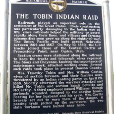
Dobytown is a ghost town in Nebraska founded in 1859 and located about three miles west of Fort Kearny, with buildings originally constructed from adobe bricks. Today only foundations and ruins remain visible at the site, marked by a commemorative plaque that documents its past.

Dobytown was founded in 1859 and became the first county seat of Kearney County while serving as a crucial supply point for travelers on the route between Missouri and the West. The town lost importance after the Union Pacific Railroad was completed in 1869, and following Fort Kearny's closure in 1871, it was gradually abandoned.

The site is best visited during daylight hours when the sun illuminates the old foundations and surrounding landscape clearly. There is no regular staff or facilities on-site, so visitors should come prepared and explore independently.

The settlement operated a Pony Express station that enabled rapid mail delivery across hundreds of miles and maintained communication in this remote region. This station played a key role in connecting distant communities and government officials during the westward expansion era.

The community of curious travelers

AroundUs brings together thousands of curated places, local tips, and hidden gems, enriched daily by 60,000 contributors worldwide.

Start exploring
Location
GPS coordinates
40.64167,-99.04750
Latest update
February 9, 2026 08:22
Around this place
Fort Kearny
United States of America

Fort Kearny

4.1 km
Great Platte River Road Archway Monument
United States of America

Great Platte River Road Archway Monument

3.2 km
Pioneer Village
United States of America

Pioneer Village

17.3 km
The Great Platte River Road Archway
United States of America

The Great Platte River Road Archway

3.2 km
Museum of Nebraska Art
United States of America

Museum of Nebraska Art

7.1 km
George W. Frank House
United States of America

George W. Frank House

8.4 km
Chautauqua Pavilion
United States of America

Chautauqua Pavilion

54 km
Salem Swedish Methodist Episcopal Church
United States of America

Salem Swedish Methodist Episcopal Church

23.7 km
Kearney County Courthouse
United States of America

Kearney County Courthouse

18 km
IOOF Hall and Opera House
United States of America

IOOF Hall and Opera House

52.3 km
George Meisner House
United States of America

George Meisner House

31.2 km
Kinner House
United States of America

Kinner House

36.2 km
Saint Luke's Protestant Episcopal Church
United States of America

Saint Luke's Protestant Episcopal Church

8.1 km
Meisner Bank Building
United States of America

Meisner Bank Building

30.6 km
United States of America

Minden United States Post Office

18.1 km
Dr. A.O. Thomas House
United States of America

Dr. A.O. Thomas House

7.5 km
John Barnd House
United States of America

John Barnd House

7.6 km
Phelps County Courthouse
United States of America

Phelps County Courthouse

35.4 km
W. T. Thorne Building
United States of America

W. T. Thorne Building

17.9 km
Fort Theatre
United States of America

Fort Theatre

6.9 km
Eddie Eugene and Harriet Cotton Carpenter Farmstead
United States of America

Eddie Eugene and Harriet Cotton Carpenter Farmstead

16 km
John J. and Lenora Bartlett House
United States of America

John J. and Lenora Bartlett House

6.5 km
Hanson-Downing House
United States of America

Hanson-Downing House

7.3 km
Klehm House
United States of America

Klehm House

7.4 km
World Theatre
United States of America

World Theatre

7 km
Turkey Creek Bridge
United States of America

Turkey Creek Bridge

45.8 km
Tobin Indian Raid Historical Marker
United States of America

Tobin Indian Raid Historical Marker

40 km
Sweetwater Mill Bridge
United States of America

Sweetwater Mill Bridge

44.6 km
Show the full map
Reviews
Share your experience

No review yet

Discussions
Start a discussion...

No discussion yet

« Dobytown - human settlement in Nebraska, United States of America » is provided by Around Us (aroundus.com). Images and texts are derived from Wikimedia project under a Creative Commons license. You are allowed to copy, distribute, and modify copies of this page, under the conditions set by the license, as long as this note is clearly visible.

Discover hidden gems everywhere you go!

From secret cafés to breathtaking viewpoints, skip the crowded tourist spots and find places that match your style. Our app makes it easy with voice search, smart filtering, route optimization, and insider tips from travelers worldwide. Download now for the complete mobile experience.

Around Us App Screenshot

A unique approach to discovering new places

Le Figaro

All the places worth exploring

France Info

A tailor-made excursion in just a few clicks

20 Minutes

Around Us
Travel Guide & Maps
Download

Send to your phone

QR Code
1

Open the camera app on your mobile.

2

Point at the QR code with your camera. A notification will appear.

3

Tap the notification to open the link.