Villarrubia de los Ojos, Administrative division in La Mancha, Spain.
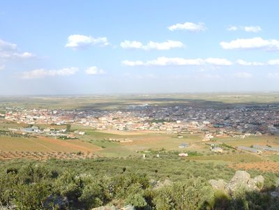
Villarrubia de los Ojos is located between the foothills of the Montes de Toledo and the flat Manchega plains, where the Gigüela and Guadiana rivers meet. The town spreads across about 281 square kilometers with roughly 9,762 inhabitants, and the municipal government office sits at Plaza de la Constitución.
The town was the site of a significant event in 1466 when Pedro Girón, Master of Calatrava, died here while traveling to meet Isabel of Castile. He was leading a large force of men, showing that this location lay on routes of historical importance.
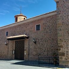
The Ethnographic Museum San Isidro Labrador displays farming tools and household items that reflect how locals lived and worked across generations. These objects show the agricultural rhythm that shaped daily life in this region.
The town is best explored on foot, with Plaza de la Constitución as the central point from which different areas are easily accessible. Visitors should allow time to visit the Ethnographic Museum and explore the surrounding areas near the rivers.
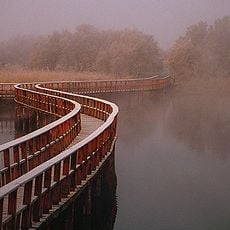
The name comes from the light-colored soil and the Ojos del Guadiana, a spring that marks the source of the fourth longest river on the Iberian Peninsula. This natural feature is something many visitors overlook, yet it defines the river's geography for the entire region.
Location: Province of Ciudad Real
Capital city: Villarrubia de los Ojos
Elevation above the sea: 624 m
Part of: Mancomunidade «Terra de Cabaleiros e Tablas de Daimiel»
Shares border with: Urda, Consuegra, Madridejos, Camuñas, Herencia, Las Labores, Arenas de San Juan, Daimiel, Fuente el Fresno
Website: http://villarrubiadelosojos.es
GPS coordinates: 39.21792,-3.60747
Latest update: December 14, 2025 11:27
Tablas de Daimiel National Park
11.5 km
Iglesia de Santa Quiteria
14.5 km
Church of Arenas de San Juan
8.9 km
Santuario de Nuestra Señora de las Cruces
18.2 km
Bullring of Daimiel
16.1 km
Biblioteca Pública Municipal de Villarrubia de los Ojos - Francisco Gómez-Porro
21 m
TO-3268
16.4 km
Scenic viewpoint
12.1 km
Scenic viewpoint
12.1 km
San Cristóbal
2.5 km
Auditorio Municipal
15.9 km
Auditorio Municipal
897 m
Monolito Avenida de la Paz
524 m
Barquero
15.9 km
Molino de Molemocho
12.3 km
Scenic viewpoint
12.4 km
Scenic viewpoint
12.2 km
Scenic viewpoint
12 km
Cueva Castrola
13.3 km
Observatorio de la Isla de Pan
12.4 km
Scenic viewpoint
11.2 km
Scenic viewpoint
11.3 km
Scenic viewpoint
10.9 km
Scenic viewpoint
10.7 km
Observatorio de la Laguna Permanente
12.3 km
Scenic viewpoint
10.4 km
Scenic viewpoint
2 km
Scenic viewpoint
15.1 kmVisited this place? Tap the stars to rate it and share your experience / photos with the community! Try now! You can cancel it anytime.
Discover hidden gems everywhere you go!
From secret cafés to breathtaking viewpoints, skip the crowded tourist spots and find places that match your style. Our app makes it easy with voice search, smart filtering, route optimization, and insider tips from travelers worldwide. Download now for the complete mobile experience.
A unique approach to discovering new places❞
— Le Figaro
All the places worth exploring❞
— France Info
A tailor-made excursion in just a few clicks❞
— 20 Minutes