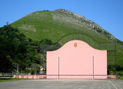
Chapeau de gendarme / Lexantzümendi, Mountain summit in Soule region, France.
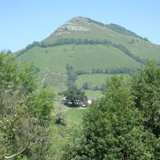
Chapeau de Gendarme is a mountain summit in Soule that stands at 572 meters with slopes covered in natural vegetation. Multiple trails wind up from different starting points, each offering varying terrain and views through the landscape.
For centuries this summit served as a natural boundary between northern Basque territories and a key reference point for people crossing the region. Shepherds and travelers relied on it to navigate the mountain landscape.
The Basque name Lexantzümendi reflects the linguistic roots of this region where the local population continues to use their native language in everyday conversation. Walking here, you encounter place names and local traditions that connect directly to Basque heritage.
Several marked trails lead to the summit from different starting points with parking areas near the main trailheads. Bring appropriate hiking boots and layered clothing as weather conditions can change quickly at elevation.
The mountain hosts the Tour de la Soule, a team race that crosses its slopes with a positive elevation gain of 960 meters over 9 kilometers.
Location: Pyrénées-Atlantiques
Location: Soule
Elevation above the sea: 572 m
Website: http://geodesie.ign.fr/fiches/index.php?module=e&action=fichepdf&source=carte&sit_no=6434001
GPS coordinates: 43.08630,-0.87904
Latest update: December 14, 2025 20:25
Château d'Eliçabéa
5 kmLigiko zubia
2.2 km
Église de Camou
4.1 km
Église de l'Assomption de Cihigue
4.5 km
Église Saint-Jean-Baptiste d'Haux
2.6 km
Mont Begousse
3.9 km
Église Saint-Jean-Baptiste de Trois-Villes
5 km
Église Saint-Étienne de Lacarry
3.7 km
Église Saint-Cyprien d'Ossas
6.1 km
Église Saint-Julien de Licq
2.1 km
Église Saint-Martin-de-Tours de Sibas
2.3 km
Église Sainte-Agnès d'Alçabéhéty
2.5 km
Église de l'Immaculée-Conception d'Etchebar
1.1 km
Église Saint-Pierre d'Alçay
2.6 km
Église de l'Assomption d'Alos
3.5 km
Église Saint-André de Lichans
822 m
Église Saint-André de Sunharette
2.3 km
Église Saint-Cyr-et-Sainte-Julitte d'Athérey
715 m
Église Saint-Julien-d'Antioche d'Abense d'Haut
2.8 km
Église Saint-Pierre de Sunhar
1 km
Église Saint-Sébastien de Laguinge
1.3 km
Église Saint-Pierre de Tardets
3.7 km
Église de Montory
5 km
Église Saint-Étienne de Restoue
2.3 km
Église Saint-Vincent d'Arhan
2.5 km
Chapelle Saint-Saturnin de Charritte-de-Haut
3 km
Monument aux morts de la guerre 1914-1918
3.7 km
Chapelle Saint-Jean-Baptiste de Bagarigue
5.4 kmVisited this place? Tap the stars to rate it and share your experience / photos with the community! Try now! You can cancel it anytime.
Discover hidden gems everywhere you go!
From secret cafés to breathtaking viewpoints, skip the crowded tourist spots and find places that match your style. Our app makes it easy with voice search, smart filtering, route optimization, and insider tips from travelers worldwide. Download now for the complete mobile experience.
A unique approach to discovering new places❞
— Le Figaro
All the places worth exploring❞
— France Info
A tailor-made excursion in just a few clicks❞
— 20 Minutes